
Albrizzi, Giambattista (sold)

Giambattista Albrizzi (1698 - 1777), a.k.a. Giovanni Battista Albrizzi, was an Italian publisher and journalist active in Venice during the mid-18th century. Albrizzi was the scion of a well-established Venetian publishing dynasty and followed in the footsteps of his father, Girolamo Albrizzi, who founded the family printing business and is known for publishing the work the great Venetian cartography Vincenzo Coronelli. Giambattista Albrizzi is generally considered to be the most prominent 18th century Venetian publisher. Today he is best known for his friendship and collaboration with Giovanni Battista Piazzeta (1683 - 1754), a well know Venetian artist and engraver, whose drawings and engravings appear in many of Albrizzi's publications, including his maps. Giambattista Albrizzi's cartographic work, while not particularly innovative in terms of content, often featured elaborate decorative elements designed by Piazzeta. Through the integration of such decorative elements, Albrizzi hopped to revive the reputation of Venetian publishing, which since the late 17th century, had fallen in regard since the days of Girolamo. His work helped lay the foundations for Italian school decorative cartography in the late 18th and early 19th century, including the work of Antonio Zatta, among others. In addition to Albrizzi's work as a map and book publisher, he also issued a weekly journal, Novelle della Repubblica delle Lettere, a kind of early newspaper that played an important role in Venetian business and intellectual life.
Scarce map of Canada and the Great Lakes on the Eve of the French and Indian War.
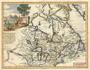
Carta Geografica Del Canada Nell' America Settentrionale.
sold
- Digital Map Information
- Suitable for large format printing
- DPI: 300
- File Size: 9.31 MB
- File Type: ZIP / TIFF
- ICC color profile embedded
- Delivered instantly via download link
An attractive 1740 map of Canada and the Great lakes by Giambattista Albrizzi. This map offers an exceptional overview of French America on the eve of the French and Indian War. Based upon a 1708 revision of a 1703 map by Guillaume Delisle, this map covers from ... (more details)
A rare decorative map of the southeastern United States in the colonial period.
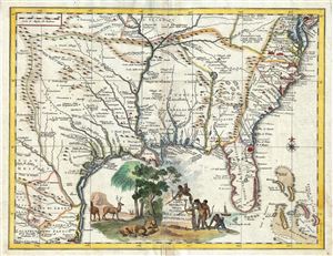
Carta Geografica Della Florida Nell' America Settentrionale.
sold
- Digital Map Information
- Suitable for large format printing
- DPI: 300
- File Size: 9.27 MB
- File Type: ZIP / TIFF
- ICC color profile embedded
- Delivered instantly via download link
This scarce map by Giambattista Albrizzi is a curious and somewhat retrogressive 1740 Italian variant on Delisle's 1718 map of Texas, Louisiana, Florida, and the southeastern British coastal colonies. Roughly following the topical model as laid down by Ortelius ... (more details)
An uncommon decorative map of North America.
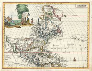
Carta Geografica Dell' America Settentrionale.
sold
- Digital Map Information
- Suitable for large format printing
- DPI: 300
- File Size: 9.32 MB
- File Type: ZIP / TIFF
- ICC color profile embedded
- Delivered instantly via download link
An attractive 1740 map of North American by Giambattista Albrizzi. Based upon an earlier map by Guillaume Delisle, this map covers all of North America from Baffin Bay to Panama and the Spanish Main and from the Atlantic to the Pacific. The western coast of ... (more details)
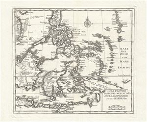
Isole Filippine Ladrones e Moluccos o Isole delle Speziarie comme anco Celebes & c.
sold
- Digital Map Information
- Suitable for large format printing
- DPI: 300
- File Size: 6.83 MB
- File Type: ZIP / TIFF
- ICC color profile embedded
- Delivered instantly via download link
An attractive 1740 map of the southern part of the Philippines or Philippine Islands. Centered on Mindano, the map covers from modern day Vietnam (Cochinchina) to the Ladrones, and from northern Luzon to the island of Timor. It includes parts of Borneo, the ... (more details)
Scarce and important 18th century Italian map of the world.
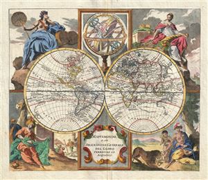
Mappamondo, o sia Descrizione Generale del Globo Terrestre ed Acuatico.
sold
- Digital Map Information
- Suitable for large format printing
- DPI: 300
- File Size: 8.35 MB
- File Type: ZIP / TIFF
- ICC color profile embedded
- Delivered instantly via download link
A striking 1750 double hemisphere map of the world by the Italian map publisher Giambattista Albrizzi. This is one of the most interesting and decorative world maps to appear in a mid-18th century atlas. Like most Italian school cartographers of this ... (more details)
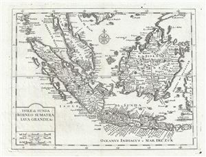
Isole di Sunda Borneo Sumatra Iava Grance & c.
sold
- Digital Map Information
- Suitable for large format printing
- DPI: 300
- File Size: 6.54 MB
- File Type: ZIP / TIFF
- ICC color profile embedded
- Delivered instantly via download link
An attractive 1740 map of the East Indies, including Malay (Malacca), Singapore, Borneo, Sumatra, and Java. Centered on the Strait of Sunda (site of the great Krakatoa Volcano), the map covers from the modern day Thai island of Phuket (Junsalan) and ... (more details)