
Arménio, Roberto (sold)

Roberto Arménio (1836 - December 25, 1900) was Neapolitan civil and military engineer. Born to Neapolitan nobility, he entered the cadet school of the Bourbon Army, graduating as an officer. He studied military engineering and joined the army's engineer corps. He was an aide to Garibaldi during the Italian wars of Unification and served with him during the Franco-Prussian War. He continued an engineering career, both for the military of Brazil and also in the civil realm in Lisbon, where he pioneered the famous Santa Justa Lift. From 1882 to 1888, he resettled in Uruguay, serving in the newly developed Military Engineering Office for the Uruguayan Army and becoming a technical advisor to President Máximo Santos. Among his other projects, he reorganized the Escuela Nacional de Artes y Oficios, and instituted an array of military reforms. Under his direction, a number of important maps and plans were created, focusing especially on hydrographic and military maps of Uruguay's frontiers, maps of Uruguay's railways, and maps of the country's rivers. He also proposed - but never executed - a canalization of the Rio Negro. In the 1890s, he continued to advise the Uruguayan chief of staff, but was not paid for these efforts. His labors were not profitable, and he died in poverty in his adopted country.
Rare reference maps for the use of the military.
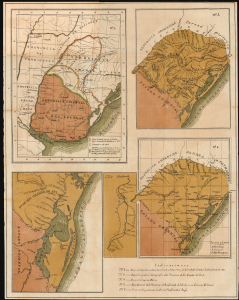
[Mapa Militar de la República O. del Uruguay. 1885, Maps 2, 3, 4, 6, and 7 of]
sold
- Digital Map Information
- Suitable for large format printing
- File Size: 18.76 MB
- File Type: ZIP / TIFF
- ICC color profile embedded
- Delivered instantly via download link
This is a rare, folding chromolithograph containing five maps focusing on Uruguay's frontiers with Brazil, specifically Rio Grande do Sul, produced in 1885 by military engineer Roberto Arménio for the use of officers of the Uruguayan Army and Navy. It accompanied Arménio's pamphlet, Mapa Militar de la República Oriental del Uruguay, which outlined plans to reform and modernize Uruguay's military. (more details)
Maps for the use by the Uruguan military.
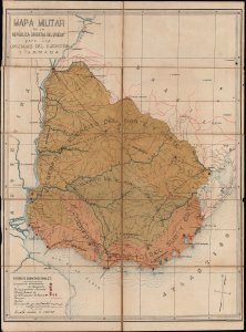
Mapa Militar de la República O. del Uruguay. 1885 [Maps 1 and 5 of 7]
sold
- Digital Map Information
- Suitable for large format printing
- Full resolution TIFF file
- ICC color profile embedded
- Delivered instantly via download link
These are Roberto Arménio's rare maps focusing on Uruguay's frontiers with Brazil and Argentina: one showing the administrative regions of the Uruguayan Army overall, and the other detailing Uruguay's fortifications along the Uruguay River (which forms the Uruguayan border with Argentina). These were produced in 1885 for the use of officers of the Uruguayan Army and Navy, and appeared in Arménio's pamphlet, Mapa Militar de la República Oriental del Uruguay, which outlined ambitious plans to reform and modernize Uruguay's military. The two maps are offered in conjunction with the pamphlet. (more details)