
Beers, James Botsford Beers (sold)

James Botsford Beers (October 16, 1811 - June 3, 1901) was an American map publisher based in Connecticut in the second half of the 19th century. Beers was born in Newtown, Connecticut. He married Huldah Clarke (1813 - 1893) on August 30, 1835, in his hometown. They had five children in 18 years of marriage. He lived in Brooklyn, New York, from about 1845 where he dealt in jewelry and gold pens. Beers started publishing maps as 'J. B. Beers' in 1863, possibly inspired by the success of John Bute Holmes (1822 - 1887). In 1867, in partnership with A.D. Ellis and G.G. Soule, published his Atlas of New York and Vicinity. His son Frederick W. Beers joined the family business in 1870, at which point the firm was renamed 'J. B. Beers and Company'. Botsford Beers is the progenitor of the prolific Beers mapmaking family - who mostly published out of New York. He worked with his brother Charles Henry Beers (November 3, 1813 - March 5, 1892), son Frederick William Beers (August 17, 1839 - September 8, 1933), and grandsons Silas Norman Beers (September 3, 1837 - May 12, 1873) and Daniel Glover Beers (October 19, 1841 - February 12, 1913).
Beers / Colton edition of the most important printed map of New York compiled during the Pre-Amercian Revolutionary War colonial period.
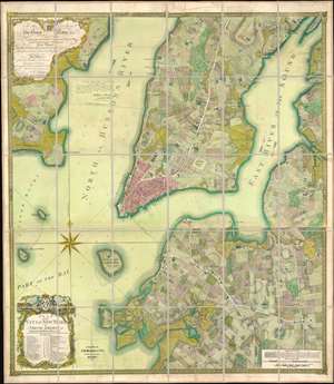
To his excellency Sr. Henry Moore, bart., captain general and governour in chief, in and over his majesty's province of New York and the territories depending thereon in America, chancellor and vice admiral of the same : This plan of the city of New York and its environs, survey'd and laid down ; is most humbly dedicated by his excellency's most obedt. humble servant B. Ratzer.
sold
- Digital Map Information
- Suitable for large format printing
- File Size: 111.61 MB
- File Type: ZIP / TIFF
- ICC color profile embedded
- Delivered instantly via download link
Known as the 'Ratzer Plan,' this is one of the most important, beautiful, and iconic colonial era maps of New York City, offered here in a stunning 1874 Colton / Beers restrike. This map was originally surveyed in 1767 by Bernard Ratzer, a lieutenant in the 'Royal American' regiment at the behest of Sir George Moore, governor of New York, who is sited in the cartouche. The map, which covers the southern part of Manhattan to about modern day 57th street, is a revision and expansion upon the flawed John Montresor plan of 1767. Across East River, a portion of Long Island is depicted, including most of Brooklyn and Parts of Long Island City. (more details)