
Brandis, Lucas (sold)

Lucas Brandis (before 1450 - after 1500) was a German printer and typographer of the incunable period/ He was educated at Leipzig University, though his apprenticeship in the printing trade is unknown, but he would begin printing under his own name in Merseburg with his first dated work appearing in 1473. At the end of that year he began work on the work for which he is best known, the 474-sheet Weltchronik Rudimentum novitiorum, which he completed in 1475 - a history of the world for the education of Novice Monks. He also published breviaries, psalters and theological works such as Josephus' De bello Judaico Not atypical of early printers, his shop was not a financial success and he would go on to work as a type caster for printer Bartholomäus Ghotan. His lack of financial success seems to have had an effect on his historical traces, which are practically nonexistent after this time. His last dated printed work comes from the year 1499; his last appearance in the historical record was in Lübeck court records ordering him in 1500 not to leave town until his debts were settled.
Rare Printing of a Medieval Mappamundi.
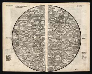
[Untitled World Map.]
sold
- Digital Map Information
- Suitable for large format printing
- Full resolution TIFF file
- ICC color profile embedded
- Delivered instantly via download link
A rare, bold example of the only medieval mappamundi or World Map available to the collector. The anonymous woodcut first appeared in the 1491 Jean Dupré Lyons printing of the Mer des Hystoires. It is derived from the 1475 world map inWelteltchronik Rudimentum Novitiorum (World Chronicle for Novices), a history penned by an anonymous clergyman but published by Lucas Brandis. The book's world map and its map of the Holy Land were described by Shirley as 'the first printed maps to try and show land forms and countries in topographical relation to each other.' The Rudimentum Novitorum, was a history of the world intended for novice monks. Consequently the maps included were not for travel so much as supporting the symbolic and moral elements of monastic education. The 1475 map from which the present map is derived is itself only predated by one other printed map, the 1472 Isidorus T-O map, and in terms of orientation and general structure these maps do share some commonality, but the mappamundi as a form is very different in content and purpose to the schematic T-O map. At the same time, mappamundi such as this would stand in sharp contrast to the systematic, mathematical maps produced according to the rules and conventions of Ptolemy which would form the underpinning of modern geography. A T-O map was a visual diagram for understanding the three parts of the known inhabited world in relation to each other, but contained no information about those places. Ptolemy's maps represented an effort to calculate the actual locations of specific places in the inhabited world, or oikoumenē, and to mark them on a graph approximating a conic section of the globe. The mappamundi would attempt no such precision, but would within its limits name the parts of the known world deemed most important - particularly to the map's Christianized context. (more details)