
Bruce-Roberts, Inc. (sold)
Bruce-Roberts, Inc. (fl. 1928 - August 1931) was a Chicago publishing firm based at 540 North Michigan Avenue. They are most famous for publishing the famous pictorial map Chicago Gangland. Advertisements for Bruce-Roberts Inc. appear in Chicago publications from 1828 through April of 1931, although they were still active in August. Following this date, there is no further evidence of the firm. On the envelope that was originally published with the Chicago Gangland map, there is some hint that they were driven out of town by city politicians (and maybe gangsters) reacting to the map. Other known work includes a book on Golf, another on the virtues of marriage, and an instructional manual on 'Winning Backgammon.' The name of the firm suggest that 'Bruce' and 'Roberts' are different people. The 1830 census identifies only 1 'Roberts' working as a publisher, George F. Roberts (1859 - 19??), who was 71 in 1930, but apparently still active. As for Bruce, this may be the Canadian born William M. Bruce (1882 - 19??), who is listed as a 'Book Publisher' in the same census.
Gangland Style! The greatest pictorial map of all time! Addressing socially, politically, and legally volitile issues!
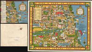
A Map of Chicago's Gangland from Authentic Sources. Designed to Inculcate the Most Important Principles of Piety and Virtue in Young Persons and Graphically Portray the Evils and Sin and Large Cities.
sold
- Digital Map Information
- Suitable for large format printing
- File Size: 52.39 MB
- File Type: ZIP / TIFF
- ICC color profile embedded
- Delivered instantly via download link
Perhaps the greatest pictorial map of all time, this is the legendary 1931 Bruce-Roberts cartoon map of Gangland Chicago, accompanied by its original mailer. Although not drawn to scale, the map covers downtown Chicago from Lincoln Park to Jackson Park and west as far as Cicero and Stickney. When this map was issued, Chicago's Prohibition Era gang wars were winding down. Al Capone, Chicago's criminal king-pin, was convicted of tax evasion and sentenced to 11 years in federal prison in October of this same year. Nonetheless, as this went to press, probably in August or September of 1931, all of Chicago was reeling from years of violent gang warfare. Unlike any previous pictorial map, the revolutionary unknown artist that drew this map is embracing politically, socially, and legally complex issues at the moment of their highest volatility. It comes thus as no surprise that the artist chose to remain anonymous. Despite its violent if cartoonish content, the map was issued with the noble intent, 'to inculcate the most important principles of Piety and virtue in young persons and graphically portray the evils and sin of large cities.' (more details)