
Bruce, James (sold)
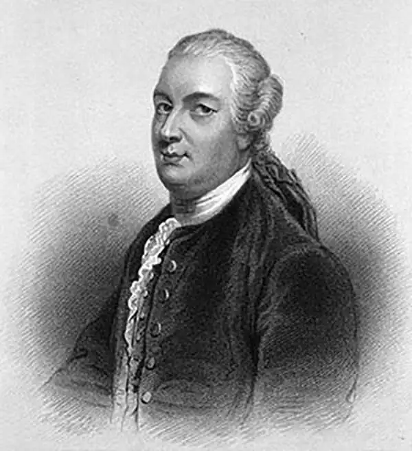
James Bruce (December 14, 1730 - April 27, 1794) was a Scottish explorer, traveler, and nobleman active in the later part of the 18th century. Bruce's romantic adventures in North Africa and Arabia make a tale worthy of Hollywood. Descended from the great Scottish King Robert the Bruce, James Bruce was born at his family seat in Kinnaird, Stirlingshire, Scotland. He was educated in Law at Harrow School and Edinburgh University and, marrying into a family business, became a wine merchant. Following the 1762 war with between England and Spain, Bruce was sent to Algiers with a commission to study Roman antiquities in the region. Many adventures followed that eventually led Bruce to Alexandria, Egypt, where he determined to discover the source of the Nile, which he believed to be in Ethiopia. Bruce traveled up the Nile and, after visiting Luxor worked his way overland to the Red Sea port of Kosseir (Old Cosseir), where he embarked upon a merchant ship disguised as a Turkish sailor. In this guise Bruce made his way to Massawa, where is disembarked and, traveling overland via Axum, arrived at the Abyssinian capital at Gondar. From Gondar, local guides led Bruce southwards to Laka Tana, and then along the Abay River to the Gish Abay springs, the legendary source of the Blue Nile. Bruce believed that the Blue Nile was the Nile of antiquity and claimed, falsely, that it was the larger of the two Nile tributaries. In his narrative Bruce further announced that he had discovered the source of the Nile, while in fact, the first Europeans to visit Gish Abay were the 16th century Spanish Jesuit Pedro Paez and, later, the 17th century Portuguese Jesuit Jeronimo Lobo. On his return journey, Bruce followed the Blue Nile to its confluence with the White, becoming the first European to visit the site. Bruce's explorations were significant and, on his return to Kinnaird, he published a lavishly illustrated narrative of his travels in five volumes. Bruce's tales of Ethiopian architecture, culture, and life where heavily ridiculed by the scholars of this day. Modern researchers, however, have proven that much of Bruce's narrative was substantial and accurate, thus affirming his significant contribution to the cartographic corpus. Snubbed by his peers, Bruce retired to Kinnaird, where he remained until his death in 1794. Modern day conspiracy theorists have added an interesting twist to Bruce's Ethiopian adventures. They claim that Bruce had a second, more important motivation - to rediscover ancient Templar secrets and artifacts hidden in Ethiopia. Some believe that Bruce, having inherited secret Templar knowledge from his ancestor, Robert the Bruce - who sheltered the Templars during their prosecution in the 14th century - was searching Ethiopia for the secrets of the Ark of the Covenant and other religious artifacts. Though Bruce kept silent on what he found, if anything, many Ethiopians maintain that the Ark of the Covenant is, to this day, kept at a sacred sanctuary in Axum.
Fascinating document illustrating Bruce's rediscovery of the source of the Blue Nile and his travels in the Red Sea.
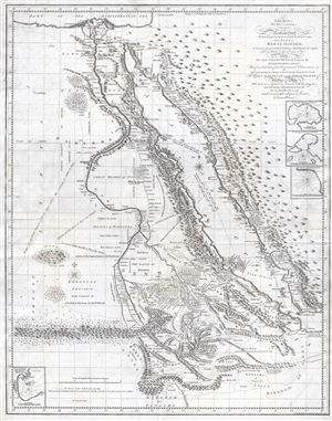
To The King. This map, Containing a Chart of the Arabian Gulf With its Egyptian, Ethiopian and Arabian Coasts, from Suez to Bab el Mandeb, A Journey through Abyssinia to Gondar, its Capital, From thence to the Source of the Nile, The Whole of that River, from its Source to the Mediterranean, Now first laid down from Astronomical Observations of All those points necessary to Aseertain the form of its Course, Teh Return by Sennaar and the Great Desert of Nubia and Beja All laid down by Actual Survey with the largest and most perfect Instruments now in use by His Majesty's most dutiful and faithful Subject & Servant, james Bruce.
sold
- Digital Map Information
- Suitable for large format printing
- DPI: 300
- File Size: 19.84 MB
- File Type: ZIP / TIFF
- ICC color profile embedded
- Delivered instantly via download link
This is a fascinating, significant, beautifully engraved, intricately detailed 1790 map of Egypt, Abyssinia, and the Red Sea by the Scottish adventurer James Bruce. Centered on the Nile Valley, this map covers all of Egypt, Abyssinia, and the Red Sea from the ... (more details)
Fascinating document illustrating Bruce's rediscovery of the source of the Blue Nile and his travels in the Red Sea.
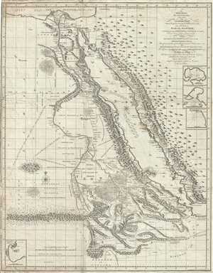
To The King. This map, Containing a Chart of the Arabian Gulf With its Egyptian, Ethiopian and Arabian Coasts, from Suez to Bab el Mandeb, A Journey through Abyssinia to Gondar, its Capital, From thence to the Source of the Nile, The Whole of that River, from its Source to the Mediterranean, Now first laid down from Astronomical Observations of All those points necessary to Aseertain the form of its Course, Teh Return by Sennaar and the Great Desert of Nubia and Beja All laid down by Actual Survey with the largest and most perfect Instruments now in use by His Majesty's most dutiful and faithful Subject & Servant, James Bruce.
sold
- Digital Map Information
- Suitable for large format printing
- DPI: 300
- File Size: 21.01 MB
- File Type: ZIP / TIFF
- ICC color profile embedded
- Delivered instantly via download link
This is a fascinating, significant, beautifully engraved, intricately detailed 1790 map of Egypt, Abyssinia, and the Red Sea by the Scottish adventurer James Bruce. Centered on the Nile Valley, this map covers all of Egypt, Abyssinia, and the Red Sea from the ... (more details)
Fascinating document illustrating Bruce's rediscovery of the source of the Blue Nile.
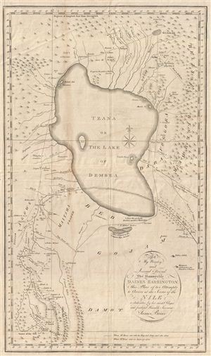
To My Worthy and Learned Friend the Honourable Daines Barrington This Plan of two Attempts to Arrive at the Source of the Nile is dedicated by his most Obliged and faithful Humble Servant James Bruce.
sold
- Digital Map Information
- Suitable for large format printing
- DPI: 300
- File Size: 8.91 MB
- File Type: ZIP / TIFF
- ICC color profile embedded
- Delivered instantly via download link
This is a fascinating, significant, beautifully engraved, intricately detailed 1790 map of Ethiopia (Abyssinia) and the source of the Blue Nile by the Scottish adventurer James Bruce. Centered on Lake Tana (Tzana), this map depicts from the Ethiopian capital at Gondar south as far as the Saccala District and the Geesh Abay (Geesh Springs). (more details)
James Bruce's African speculations on the Lost Mines of King Solomon at Ophir and Tarshish.
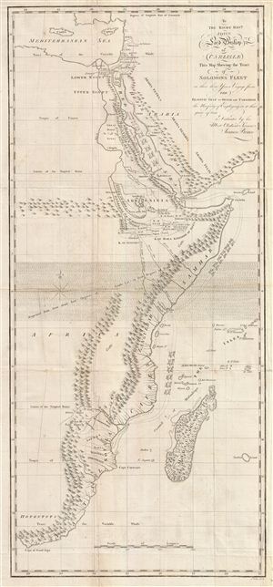
To the Right Revd. John Lord Bishop of Carlisle This Map Shewing the Tract of Solomons Fleet in thir three Years Voyage from the Elantic Gulf to Ophir and Tarshish the Necessity of Empolying in it that space of time is Dedicated by his Most Obedient Servent James Bruce.
sold
- Digital Map Information
- Suitable for large format printing
- Full resolution TIFF file
- ICC color profile embedded
- Delivered instantly via download link
This is a fascinating, significant, beautifully engraved, intricately detailed 1813 map of eastern Africa, covering from the Mediterranean to the Cape of Good Hope. The map serves to highlight Bruce's speculations, which follow those of Montesquieu, ... (more details)