
Chevalier, August (sold)

August Chevalier (1871 – November 29, 1934) was a French-born American lithographer living and working in San Francisco, California. He came to the United States in 1890. Nothing is known about his early life and education, but he appears to have made his name with the publication of his 1904 work 'The Commercial, Pictorial and Tourist map of San Francisco': Chevalier's wife, Josephine, came to America from France that year, so perhaps the publication of his first map provided the means for bringing her to join him. Chevalier would go on to produce half a dozen plans of his home city, of which his magnificent 1912 topographical map of San Francisco known as 'The Chevalier' is best known. In 1931 he produced a series of 'Aero-Map-Views' of various regions of California, all of which appear to be quite rare.
Rare Tourist's Pocket Map of San Francisco Highlighting The Iconic Street Car Routes
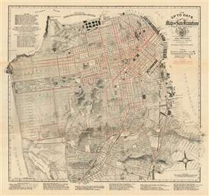
The Up To Date Map of San Francisco From Latest U.S. Gov. and Official Surveys.
sold
- Digital Map Information
- Suitable for large format printing
- File Size: 30.76 MB
- File Type: ZIP / TIFF
- ICC color profile embedded
- Delivered instantly via download link
This is August Chevalier’s updated 1915 map of San Francisco. Produced in pocket-map format for the use of visitors to both the city and the then-active Panama-Pacific International Exposition, the map details the city's neighborhoods, parks, and other features needful to the visitor. Buildings of particular importance - the newly built city hall, the mint, the post office, railroad depots, Sutro Baths, Cliff House, and others - are shown pictorially. The city's distinctive topography is shown with a combination of hachure and contour lines, including elevations. The map provides lists, keyed to coordinates on the map, of Theaters, railway depots, post offices, and 'Places of Interest.'
The map also features excellent transportation information, including railroads, bridges, tunnels, and steamer piers - including prospective ones. Most distinctive to San Francisco are the “car lines” in red: the now-dwindling cable car and electric street car routes that once spanned virtually the entire city. (more details)
The map also features excellent transportation information, including railroads, bridges, tunnels, and steamer piers - including prospective ones. Most distinctive to San Francisco are the “car lines” in red: the now-dwindling cable car and electric street car routes that once spanned virtually the entire city. (more details)
One of the most beautiful early 20th century maps of San Francisco.
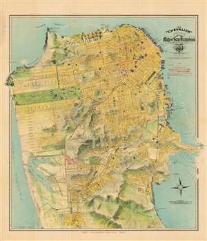
The 'Chevalier' Commercial Pictorial and Tourist Map of San Francisco.
sold
- Digital Map Information
- Suitable for large format printing
- File Size: 44.55 MB
- File Type: ZIP / TIFF
- ICC color profile embedded
- Delivered instantly via download link
This is the 1912 'Chevalier' map of San Francisco, one of the most beautiful early 20th century maps of the city. This remarkable chromolithographic topographical and pictorial map of San Francisco was issued by August Chevalier, a French-born American lithographer living and working in the city. Named 'The Chevalier' after its author, the map covers the city from the Golden Gate Park to Colma, and from the Pacific Ocean to San Francisco Bay. Hunter's Point and Point Lobos, the eastern and western extremities of the peninsula respectively, break through the printed borders into the margins of the map (unusually generous, in the case of this example of the map). The city's grid structure is overlaid on a topographical map much as the real-life San Francisco street grid is overlaid on the peninsula's impressively hilly terrain, producing the city's unique topography of steep streets and sharp sudden inclines. Important buildings are shown pictorially. Overprinting in red identifies proposed tunnels and trolley lines. Proposed improvements and landfills are ghosted in at the eastern side of the city surrounding Hunter's Point. The map is accompanied by a detailed, 96-page guide with art-nouveau covers. Of the variants of Chevalier's map, this is one of the most desirable for its association with the Panama-0Pacific Exposition and bright color. (more details)
One of the most beautiful early 20th century maps of San Francisco.
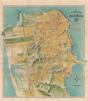
The 'Chevalier' Commercial Pictorial and Tourist Map of San Francisco.
sold
- Digital Map Information
- Suitable for large format printing
- File Size: 21.85 MB
- File Type: ZIP / TIFF
- ICC color profile embedded
- Delivered instantly via download link
One of the most beautiful early 20th century maps of San Francisco. This remarkable 1915 chromolithographic topographical and pictorial map of San Francisco, California was issued by August Chevalier. Named 'The Chevalier' after its author, the map covers the ... (more details)