
Clarke, William Barnard (sold)

William Barnard Clarke (1806 - 1865) was an English cartographer, architect, numismatist, literary translator, art collector, and archaeological writer. Born in Cheshunt, Hertfordshire, Clarke attended St. Paul's School in London beginning in 1817 at the age of 10. It is said that as a youth Clarke spent a substantial amount of time in Rome studying architecture and also spent time studying the ruins of Pompeii. He was also instrumental in founding the Architectural Society of London and was named President of the Society in 1831. As a cartographer, Clarke was an active member of the Society for the Diffusion of Useful Knowledge and created a Celestial Atlas for the Society as well as city plans of Dublin, Milan, Warsaw, Paris, and London among several others. Clarke married Charlotte Brooks at St. Andrew Holborn in London on July 1, 1830.
Rebuilding after the Revolution.
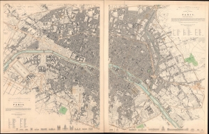
Western division of Paris. / Eastern division of Paris.
sold
- Digital Map Information
- Suitable for large format printing
- Full resolution TIFF file
- ICC color profile embedded
- Delivered instantly via download link
A 1834 two-sheet map or plan of the city of Paris, France, by the Society for the Diffusion of Useful Knowledge (S.D.U.K.). (more details)
Wonderful city plan of Florence, considered by many to be the birthplace of the Renaissance.
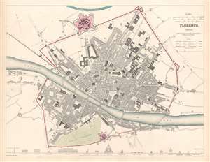
Florence Firenze.
sold
- Digital Map Information
- Suitable for large format printing
- Full resolution TIFF file
- ICC color profile embedded
- Delivered instantly via download link
This is an 1835 Society for the Diffusion of Useful Knowledge city map or plan of Florence, Italy. The map depicts the city from the Porta al Prato to the Porta alla Croce and from the Mugnone River to the Boboli Gardens and the Porta Romana. Important historic sites, such as the Duomo, the Fortezza de Basso, labeled here as the Castello San Gio Batista, the Boboli Gardens, and the Ufizi Gallery, are labeled. Streets, squares, churches, and other sites throughout the city are also identified. Profile views of sixteen important sites around Florence, including the Duomo (cathedral), Pitti Palace, the Baptistery, and the Medici Palace adorn the bottom border. (more details)
Beautiful city plan of Dublin, Ireland's capital city.
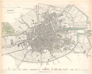
Dublin.
sold
- Digital Map Information
- Suitable for large format printing
- DPI: 600
- File Size: 13.67 MB
- File Type: ZIP / TIFF
- ICC color profile embedded
- Delivered instantly via download link
This is a lovely 1836 map of the city of Dublin, Ireland issued by the Society for the Diffusion of Useful Knowledge, or S.D.U.K. It depicts the city of Dublin, at the time confined mainly within the Circular Road located at the mouth of the Liffey River, including part of Phoenix Park. Highly detailed, the map notes individual streets, buildings, parks, squares, and docks. Trinity College is labeled to the right of center, with several hospitals, the military barracks, and the College Botanic Gardens among the other identified locations around the city. Artistic profile views of fourteen of the most important buildings of the city, such as St. George's Church, the Royal Exchange, St. Patrick's Church, and Nelson's Pillar. (more details)