
Cordier, Robert (sold)

Robert Cordier (16?? - c. 1673) was a French engraver and calligrapher active in Paris in the late 17th century. Originally from Abbeville, Cordier (and his brother Louis) were known for engraving works for Nicolas Sanson, who was also from Abbeville, and Hubert Alexis Jaillot. There are records of an engraver by the same name working in Madrid from 1629 - 1653, likely the same person. He also engraved images for the work of several prominent French novelists during his career.
Illustrates California as an Island and makes an explicit textual reference to the same theory.
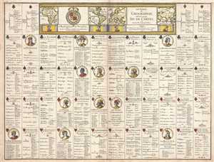
Les Tables de Geographie, reduites en un Jeu de Cartes.
sold
- Digital Map Information
- Suitable for large format printing
- DPI: 300
- File Size: 8.56 MB
- File Type: ZIP / TIFF
- ICC color profile embedded
- Delivered instantly via download link
This is a 1669 Pierre du Val broadside of an uncut complete deck of fifty-two playing cards. Akin to a conventional deck of cards, each of the four traditional suits corresponds with a continent: clubs for the Americas (both North and South), spades for Africa, ... (more details)
The first appearance of the Marquette-Joliet Mississippi River cartography.
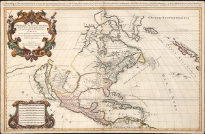
Amerique septentrionale divisée en ses principales parties, ou sont distingués les vns des autres les estats suivant qu'ils appartiennent presentemet aux Francois, Castillans, Anglois, Suedois, Danois, Hollandois, tirée des relations de toutes ces nations par le S. Sanson, geographe ordinaire du roy. 1674.
sold
- Digital Map Information
- Suitable for large format printing
- Full resolution TIFF file
- ICC color profile embedded
- Delivered instantly via download link
An impressive and scarce 1674 map of North America issued by Alexis-Hubert Jaillot, offered here in its first edition, and likely exhibiting preliminary data from the 1673 Marquette-Joliet Expedition. The map covers North America and Central America from Baffin Bay to the Spanish Main. It extends westward past an Insular California to include Terre de Iesso (a speculative mapping of Hokkaido) and eastwards past the Azores to include the British Isles. It includes a striking mapping the Mississippi (Chucagua), that while inaccurate in the southernmost regions, likely reflects Joliet's verbal reports from the seminal 1673 Marquette-Joliet Expedition. (more details)