
Craskell, Thomas (sold)

Thomas Craskell (17xx - May 1790) was a British civil engineer, architect, and artist based in Jamaica in the mid-18th century. Little is known of his youth, education, or even birth date, though this was likely about 1720. He first appears as a lieutenant in the Engineer Corps accompanying Major-General Peregrine Hopson (1696 - 1759) in the 1759 British invasions of Martinique and Guadeloupe. He later became the Chief Engineer of Jamaica. As an architect, he designed the neoclassical governor's mansion 'King's House' (1762), located in Spanish Town, Jamaica. Craskell was also an accomplished maritime painter in the mid-19th-century school of Peter Monamy (1681 - 17549) and Samuel Scott (c. 1702 - 1772), both of whom he considered friends. His precise rendering of sails and rigging suggests a deep knowledge of maritime engineering. Only four known paintings by Craskell survive. His cartographic output is limited to three large-format maps of Jamaica, completed with James Simpson, and published in 1763. His son, also Thomas Craskell, was appointed Superintendent General of the Maroons of Trelawny Town to replace Major John James.
Slave-suppression Masterplan.
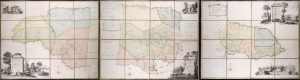
To the Right Honorable Robert Earl of Holdernesse, this map of the County of Cornwall, in the Island of Jamaica. (laid down from the papers, and under the direction of Henry Moore Esqr. His Majesty's Lieutenant Governor, and Commander in Chief of that Island, in the years 1756,-57,-58,-59,-60, and 61, and from a great number of actual surveys performed by the publishers) is humbly inscribed. / To the Right Honorable Wills Earl of Hillsborough, First Lord Commissioner of Trade and Plantations, this map of the County of Middlesex, in the Island of Jamaica. (laid down from the papers, and under the direction of Henry Moore Esqr. His Majesty's Lieutenant Governor and Commander in Chief of that Island in the years 1756,-57,-58,-59,-60, and 61, and from a great number of actual surveys performed by the publishers) is humbly inscribed. / To the Right Honorable George Grenville Esqr. First Lord Commissioner of the Treasury, Chancellor and under Treasurer of the Exchequers and c. and c. This map of the County of Surry, in the Island of Jamaica. (laid down from the papers and under the direction of Henry Moore Esqr. His Majesty's Lieutenant Governor and Commander in Chief of that Island in the years 1756,-57,-58,-59,-60, and 61, and from a great number of actual surveys performed by the publishers)is humbly inscribed.
sold
A seminal production, this is the 1763 Craskell-Simpson map of Jamaica, in three parts. It is the first broadly accurate map of Jamaica and the template for most subsequent representations of the island until the Roberston map of 1804. More importantly, the Craskell-Simpson map is best understood as a response to Tacky's Rebellion (April 1760 - October 1761) and, as such, is a masterplan for slave suppression. The map was commissioned by Henry Moore (1714 - 1769), who also, ironically, commissioned the Ratzer plan of New York, then likewise on the cusp of rebellion. It is the only work (either written or graphic) that records virtually every plantation and pen (large farms) in Jamaica at the height of the island's sugar boom, when it was the most valuable possession of the British Empire. (more details)