
Crépy, Jean-Baptiste (sold)

Jean-Baptiste Crépy (fl. c. 1730 - 1796), also spelled Creepy, was a French map and print publisher based in Paris during the middle of the 18th century. His father Etienne-Louis Crépy, son of Jean Crépy (1660-1739). Within the family dynasty Jean-Baptiste was known as Crépy le Jeune, or Crépy the Younger. His work ranged from maps, such as his reprint of the Le Rouge issue of the Popple Key Map, to general prints, and even geographically themed board games. He is known to have worked with other French mapmakers o the period including André Basset. maintained offices at Rue St. Jacques a St. Pierre near la Rue de la Parcheminerie. The Crépy firm went into bankruptcy and liquidated at auction on the 24th of April, 1790. Jean-Baptiste Crépy died in 1796.
French edition of a landmark British map of North America.
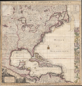
Carte Générale De L'Amérique Septentrionale Avec les possessions Angloises dans cette partie du nouveau monde, Dressée sur la carte de Pople, publiée à Londres en 20 feuilles, pour servir à l'intelligence de la guerre présente.
sold
- Digital Map Information
- Suitable for large format printing
- DPI: 300
- File Size: 21.59 MB
- File Type: ZIP / TIFF
- ICC color profile embedded
- Delivered instantly via download link
An attractive example of the c. 1756 Crepy edition of Popple's Key Map. Popple's map is considered one of the most important maps of North America issued in the 18th century. (more details)
The site of the first naval engagement of the Seven Years' War.
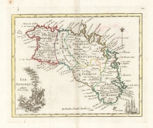
Isle Minorque a paris Chez Crepy.
sold
- Digital Map Information
- Suitable for large format printing
- DPI: 600
- File Size: 9.31 MB
- File Type: ZIP / TIFF
- ICC color profile embedded
- Delivered instantly via download link
This is a handsome, scarce example of George-Louis Le Rouge's 1759 map of Minorca. It was the last of a hundred maps in his Atlas Nouveau Portatif, which compiled an array of maps relevant to the Seven Years' War's European theatres. Minorca, therefore, was an important inclusion, being the site of the opening naval battle of that war in 1756. The map depicts Minorca and its provincial divisions as they stood during Britain's control of the Island, but the map was produced in the immediate aftermath of the battle by which the French ended British rule in Minorca, taking from Britain her primary Mediterranean base and effectively passing control of that sea to the French.
The maps for Le Rouge's Atlas were mainly sourced from those of Homann and Mayer, and the source for this map was published the year after the Battle of Minorca by Homann Heirs. It had been drawn by the French Royal Geographer, Jean de Beaurain; consequently it presented not only the most recent but the most authoritative mapping of the crucial Mediterranean strongpoint. (more details)
The maps for Le Rouge's Atlas were mainly sourced from those of Homann and Mayer, and the source for this map was published the year after the Battle of Minorca by Homann Heirs. It had been drawn by the French Royal Geographer, Jean de Beaurain; consequently it presented not only the most recent but the most authoritative mapping of the crucial Mediterranean strongpoint. (more details)
One of the first maps to recognize the American Revolution.
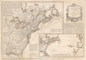
Carte Nouvelle des Possessions Angloises en Amérique dressée pour l'intelligence de la guerre présente et divisée suivant les prétentions des Anglois...
sold
- Digital Map Information
- Suitable for large format printing
- Full resolution TIFF file
- ICC color profile embedded
- Delivered instantly via download link
This is Maurille Antoine Moithey's rare separately issued April 1777 broadside map of the fledgling United States, one of the earliest general maps of the British Colonies to reflect the commencement of the Revolution. Issued in Paris, the map traces events in the early stages of the American Revolutionary War (1775 - 1783) with historical context as far back as the French and Indian War (1754 - 1763). Moithey issued this map to address French interest in the American Revolution - which was riding high at the time. The map predates by several months the 1778 signing of the Treaty of Alliance between France and the emergent United States. (more details)