
Eaton, Frank Adair (sold)

Frank Adair Eaton (January 23, 1887 - July 27, 1944) was a Canadian artist active in the newspaper, magazine, and advertising industry. Eaton worked as the rotogravure editor of the New York Tribune, until he left in 1924 when he became vice president of Underwood and Underwood. Then, he worked in the magazine industry from 1926 until 1942, when he was he was art director and managing editor for Stage magazine and then Art Editor at Cue magazine. He became advertising-publicity director for Pathe News in 1942. He married Helen McSweeney on February 2, 1921, with whom he had one child.
Summer Theater in New England.
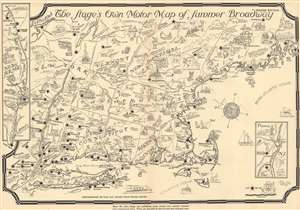
The Stage's Own Motor Map of Summer Broadway. Revised Edition.
sold
- Digital Map Information
- Suitable for large format printing
- File Size: 13.02 MB
- File Type: ZIP / TIFF
- ICC color profile embedded
- Delivered instantly via download link
This is a 1933 Frank Eaton pictorial map of New England highlighting the region's playhouses. Black stars mark towns where playhouses host summer Broadway troupes, including Stockbridge (Berkshire Players), Dennis (The Cape Playhouse), Provincetown (Wharf Theatre), and Peterborough (Mariarden Stage). Interesting facts accompany some of these places, such as Hyde Park (home of Franklin D. Roosevelt - then President of the United States). Pictorial vignettes continue the map's charm and very from the comedic ('More Moose Than Actors This Way' in Maine) to informative ('Beware of Deer on the Roads' or 'Don't Hesitate to Ask Directions'). Dotted lines mark highways, old post roads, and even 'presumed' locations of Native American trails. An inset along the left border details the coast of New Jersey from Sandy Hook to Cape May, with illustrations of Atlantic City. A second inset in the lower right depicts from Pennsylvania to Delaware along the Delaware River and highlights Moylan and Arden. (more details)
New York's Theater District!
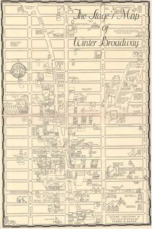
The Stage's Map of Winter Broadway.
sold
- Digital Map Information
- Suitable for large format printing
- File Size: 10.59 MB
- File Type: ZIP / TIFF
- ICC color profile embedded
- Delivered instantly via download link
This is a 1933 Frank Eaton pictorial map of the Theater District in New York City. Encompassing from Eighth Avenue to Fifth Avenue and from 59th Street and Columbus Circle to 40th Street, the map features perspective illustrations of the district's theaters. The Winter Garden, Roxy, Apollo, Rialto, Music Box, Lyric, and New Amsterdam appear, along with numerous others. Buildings depicted are almost exclusively theaters, although Patience and Fortitude (the lion's standing sentinel in front of the New York Public Library Stephen A. Schwarzman Building) do appear in Bryant Park. Rockefeller Center and Radio City Music Hall (Radio City is a theater - the largest in the world in 1933 per the map - but it isn't a Broadway theater) dominate the map's right side. Comedic portraits of the district's visitors and entertainers are included as well. Humorous comments, such as 'If you think your cartographer is going to draw in all the windows in this 70-story building you're crazy', provide levity. (more details)