
Fox, William F. (sold)

William F. Fox (January 11, 1840 - June 16, 1909) was an American engineer, historian, and administrator. He became the Superintendent of Forests at the Adirondack Park in New York State. Fox was born in Ballston Spa, New York to a family in the lumber trade, and graduated Union College in 1860, having studied to become an engineer. Soon enough, any career plans were put on hold with the onset of the American Civil War: He joined the 107th New York Volunteers and fought in the War, receiving a commission and advancing in rank as Captain, Major, and Lieutenant Colonel. He would commit his experiences to paper, contributing to postwar efforts to enumerate the horrors of the conflict: His 'Chances of Being Hit in Battle' was published by Century Magazine in 1888, and the following year he published 'Regimental Losses in the American Civil War.' He wrote a three volume history of the action of New York soldiers at the battle of Gettysburg as well as histories of several Union generals. In addition to his writing, Fox would continue in his family's lumber business; he travelled abroad to study modern methods in the trade, and he worked as a forester on behalf of the Blossburg Coal, Mining and Railroad Company in Pennsylvania. In 1885 he became assistant secretary to the New York State Forest Commission, served as Assistant Forest Warden from 1888 to 1891, and became the first Superintendent of Forests upon the creation of the Adirondack Park in 1892. His work as Superintendent provided the basis for the founding of the New York State College of Forestry at Cornell.
Reconciling State and Private Land Ownership.
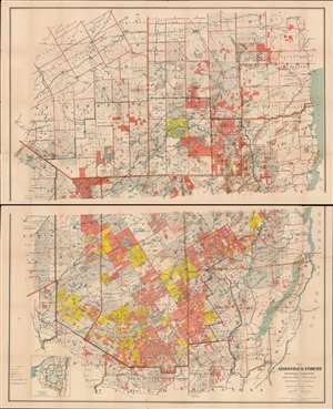
Map of the Adirondack Forest and Adjoining Territory Compiled from Official Maps and Field Notes on file in the State Departments at Albany, N.Y.
sold
- Digital Map Information
- Suitable for large format printing
- Full resolution TIFF file
- ICC color profile embedded
- Delivered instantly via download link
An uncommon large scale 1898 William Fox map of the Adirondack mountains of New York. The map covers the entire Adirondack Mountain region, extending from Saratoga to Plattsburg, and from Lewis County to Lake George and Lake Champlain. The map was made on behalf of the State Fisheries, game Commission for administrative purposes. The boundaries of the Adirondack State Park are defined by a bold blue line. Additional color coding designates the state of various lands. Pink shading identifies state forest preserve lands, yellow illustrates those lands bought or contract by the Forest Preserve Board, and lighter pink lands in which the state has joint ownership. (more details)
First State map of the Catskill Forest Preserve.
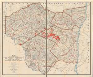
Map of Lands Belonging to the Forest Preserve situated in the Counties of Delaware Greene Sullivan and Ulster. Compiled from the Official Maps and Field Notes on file in the State Departments at Albany, N.Y. By authority of the Fisheries, Game and Forest Commission.
sold
- Digital Map Information
- Suitable for large format printing
- Full resolution TIFF file
- ICC color profile embedded
- Delivered instantly via download link
This is the first official map of the Catskill Forest Preserve, issued in 1899. It was produced by the New York State Fisheries, Game, and Forest Commission under the supervision of William F. Fox, then the Superintendent of Forests for New York State. This mammoth map, printed to two sheets (four feet wide if joined), is centered on Delaware, Greene, Sullivan and Ulster Counties in New York State, on the west bank of the Hudson River. It shows the boundaries of counties, towns, and individual tracts of land within those counties, with areas of forest reserve highlighted in red. Water routes, roads, and railroads are also detailed. Streets are named. Mountains are shown pictorially in hachure. (more details)
The Catskill Forest Preserve.
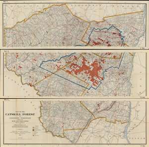
Map of the Catskill Forest and Adjoining Territory Compiled from Maps and Field notes Partially Revised 1911.
sold
- Digital Map Information
- Suitable for large format printing
- Full resolution TIFF file
- ICC color profile embedded
- Delivered instantly via download link
This is the Edward B. Codwise revised 1911 edition of the William Fox map of the Catskill Forest Preserve. It was produced by the New York State Fisheries, Game, and Forest Commission under the supervision of the civil engineer Edward B. Codwise. This mammoth map, printed to three sheets (joinable), is centered on Delaware, Greene, Sullivan and Ulster Counties in New York State, on the west bank of the Hudson River. It shows the boundaries of counties, towns, and individual tracts of land within those counties, with areas of forest reserve highlighted in red. Water routes, roads and railroads are also detailed; streets are named. Mountains are shown pictorially in hachure. (more details)