
Fujita Ryou (sold) (藤田良)

Fujita Ryou (藤田良; fl. 1850 - 1959), also known as 'Kousai' was a Japanese cartographer of the late Edo Period. He produced a large map of Hokkaido in 1854. He is otherwise elusive.
AKA: 藤田良
Defending the borders in the wake of Commodore Perry.
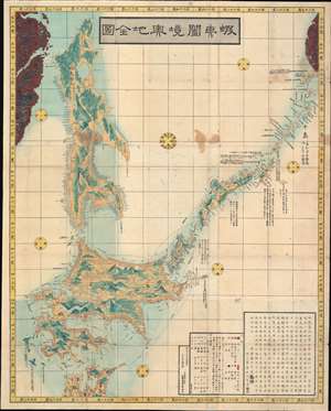
蝦夷闔境輿地全図 / Ezo Kokyou Yochi Zenzu. / Complete Map Ezo Border.
sold
- Digital Map Information
- Suitable for large format printing
- DPI: 600
- File Size: 120.07 MB
- File Type: ZIP / TIFF
- ICC color profile embedded
- Delivered instantly via download link
This is a rare 1854, Kaei 7, Japanese Edo period Fujita Ryou (橋本貞秀) chromoxylographic map illustrating Hokkaido, Sakhalin, and the Japanese Kuril Islands. It was issued following the 1853 arrival of Commodore Matthew Perry anticipating the opening of Hakodate as one of the 5 Japanese treaty ports. The maps coverage extends north from the tip of Honshu to include Sakhalin Island and the Kuril Islands as far as Kamchatka. This is a practical map, intended for actual Japanese voyages, both military and trade, and thus features copious annotations and coastal notes. A preface in Chinese is added to the end of the map, and 16 Ainu words are listed as 'dialect translation abbreviations'. (more details)