
G.M. Hopkins Company (sold)

G. M. Hopkins Company (Griffith M. Hopkins; 1865 - 1940, 1943 - today) was an American civil engineering and surveying firm based in Philadelphia. Founded in Philadelphia in 1865 by brothers Griffith Morgan Hopkins (1834 - 1901) and Henry W. Hopkins (1838 - 1920) as G.M. Hopkins and Company, the firm focused primarily on real estate plat maps of the Eastern seaboard. The firm published 175 plat map atlases depicting cities, counties, and townships in 18 states and the District of Columbia and was among the first to create a cadastral atlas. Henry Hopkins supervised much of the surveying work. G.M. retired in 1900 (and died the following year), which allowed Henry to take control of the business, which he renamed the G.M. Hopkins Company in 1902. Henry retired in 1902 and sold the business to George B. C. Thomas, who had been working for the firm since 1896 as an engraver. The G. M. Hopkins Company was purchased by the Franklin Survey Company of Philadelphia in 1943, which continued publishing atlases under the Hopkins imprint. In 1986, the company was renamed Franklin Maps and is still in operation today.
A detailed and rare city map of Chattanooga.
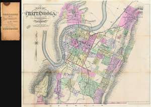
City of Chattanooga, Tennessee and Vicinity
sold
- Digital Map Information
- Suitable for large format printing
- File Size: 25.24 MB
- File Type: ZIP / TIFF
- ICC color profile embedded
- Delivered instantly via download link
This is an uncommon 1889 G.M. Hopkins city plan or map of Chattanooga, Tennessee. The map depicts the city from Lookout Mountain to Sherman Heights and from Hill City to Georgia, and the Tennessee River meanders its way across the sheet, with Chattanooga situated in one of its bends. City wards in Chattanooga are color coded to allow for easy differentiation and numerous streets are labeled, although the only building identified is the Hamilton County Court House. Chattanooga's many railroad lines are illustrated and labeled, including the electric railroad and the Mount Lookout Narrow Gauge Railroad. The city's topography is illustrated and both Mississippi Ridge and Stringer's Ridge are labeled. (more details)
The most detailed early atlas of Miami.
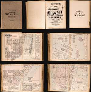
Plat Book of Greater Miami Florida and Suburbs from Official Records, Private Plans and Actual Surveys.
sold
This is the rare and significant 1925 first edition of the G. M. Hopkins atlas of Miami and Miami Beach. The atlas contains the most detailed early maps of Miami Beach. While, in most cases, insurance atlases like this volume are not significant, the opposite is the case of the G. M. Hopkins' Miami Atlas. Short of rare official maps and unobtainable manuscripts, it represents the earliest obtainable maps of Miami Beach, and to a lesser extent, Miami. As a point of reference, although there are earlier development maps, the first official map of Miami Beach was not drawn until 1920 and not committed to print until 1925 - the same year this atlas went to press. (more details)
A plat book of Miami on the eve of American involvement in World War II.

This is an extraordinary and rare 1936 - 1940 G.M. Hopkins Company cadastral plat atlas of Miami and Miami Beach, Florida - as such chronicling the development of Miami's iconic art deco architecture. The atlas consists of 53 maps, 40 of Greater Miami and 15 of Miami Beach. Coverage is detailed and extensive, including downtown Miami, Coral Gables, Little Havana, Edgewater, the Art Deco District, Ocean Drive, the Lincoln Road Mall, Star Island, Venetian Island, Hibiscus Island, Palm Island, Belle Isle, Indian Creek, etc. The detail throughout is outstanding, naming theaters, office buildings, hotels, public utilities, private properties, golf courses, racetracks, and much much more. This atlas was designed for use by the insurance industry to help assess property risk and value. Moreover, the maps were intended to be updated and revised as properties changed with labeled cutout pastedowns. Most, if not all, of the maps in this atlas exhibit such changes, bringing the plat book current to roughly 1973. (more details)
A plat book of Miami Beach illustrating the many changes in the city over a twenty-year period.
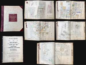
Plat-Book of Miami Beach to Golden Beach also Virginia Key and Key Biscayne Florida.
sold
This is a rare and extraordinary 1952 G. M. Hopkins Company cadastral plat atlas of Miami Beach, Florida. Containing 29 maps, illustrating every part of the city, including the Art Deco District, Ocean Drive, the Lincoln Road Mall, Star Island, Venetian Island, Hibiscus Island, Palm Island, Belle Isle, Indian Creek, etc. The detail throughout is outstanding, naming theaters, office buildings, hotels, public utilities, private properties, golf courses, racetracks, and much much more. This atlas was designed for use by the insurance industry to help assess property risk and value. Moreover, the maps were intended to be updated and revised as properties changed with labeled cutout pastedowns. Most, if not all, of the maps in this atlas exhibit such changes, bringing the plat book current to roughly 1973. (more details)