
Goos, Pieter (sold)

Pieter Goos (1616 - 1675) was a Dutch cartographer, engraver, publisher and bookseller. Goos was born in Amsterdam, the son of cartographer, globemaker, and engraver Abraham Goos (1590 - 1643). Goos followed in his father's footsteps as a mapmaker and engraver, working with Petrus Kaerius, C.J. Visscher, John Speed, Henricus Hondius, and Johannes Janssonius, among others. Goos began publishing on his own account in 1657 and, from 1666, began issuing a series of well-received nautical atlases. His De Zee-Atlas Ofte Water-Wereld is considered one of the most extraordinary maritime atlases of the Dutch Golden Age. His most famous and elusive atlas, however, was 'The Burning Fen,' Het brandende veen verlichtende de kust van Africa ende America, a collaboration with the mathematician Arent Roggeveen (1658 - 1679). When Goos died in 1675, his widow, Margareta van den Keere, sold his copper printing plates to the publisher Jacobus Robijn (c. 1649 - 1707), who reissued many of them.
One of the Finest Northeast Charts of the Dutch Period.
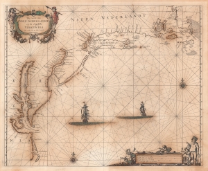
Pas Caerte van Nieu Nederlandt en de Engelsche Virginies van Capo Cod to Cabo Canrick.
sold
- Digital Map Information
- Suitable for large format printing
- Full resolution TIFF file
- ICC color profile embedded
- Delivered instantly via download link
A striking original color 1666 Pieter Goos nautical chart or maritime map of New England, New York, New Jersey, and Virginia. Coverage follows the coast of North America from Boston Harbor to Cape Hatteras, thus embracing one of the more active mid-17th century maritime corridors in North America. At the center of the map, two Dutch ships ply the seas. Finely engraved decorative cartouche work in the upper left and lower right emphasizes the region's rich fur trade and abundant fisheries. (more details)
Dutch Sea Chart of the Straits of Magellan and Le Maire, and the Rio de la Plata.
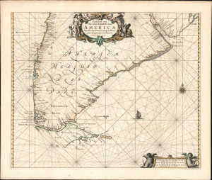
Paskaarte van Het Zuydelijckste van America Van Rio de la Plata, tot Caap de Hoorn, ende inde Zuyd Zee tot B. de Koquimbo. Nieuwlijcks Vijtgegeven Anno 1666.
sold
- Digital Map Information
- Suitable for large format printing
- File Size: 21.05 MB
- File Type: ZIP / TIFF
- ICC color profile embedded
- Delivered instantly via download link
This is Pieter Goos' 1666 nautical map of the southernmost parts of South America, from the region around the Rio de la Plata to Tierra del Fuego. As with Goos' other output, this is among the most beautifully engraved regional nautical charts. This is the second-earliest specific chart of the region, predated only by the chart of Johannes van Loon. (more details)