
Grierson, George (sold)

George Grierson (1680 - October 27, 1753) was an Irish printer and publisher active in Dublin during the first part of the 18th century. Grierson began publishing when he married Jane Blow, a daughter of the prominent Irish paper making and publishing family of James Blow. In 1727, he was admitted as a Freeman to the city of Dublin and was appointed to the office of Printer General to His Majesty in Ireland. Operating under the title, 'Kings Printer in Dublin' from 1732 to 1753, Grierson was the only printer in Dublin allowed to print Holy Bibles. Later Grierson's attention turned toward cartography, which he identified as a profitable sideline to Bible work. Most of Grierson's cartographic work involved pirating the work of the prominent English eccentric and map publisher Herman Moll. Grierson's first 'Moll' piracies were published shortly following Moll's death in 1732. Though superficially identical to the maps in Moll's The World Describ'd, Grierson's maps are in fact complete re-engravings, often with new cartouche work bearing unique ‘Irishcentric' dedications and themes. Grierson also issued piracies of The English Pilot and Salmon's Modern History. Although George Grierson can be credited with few original maps, his work established Dublin as a center for cartographic engraving and publication in the 18th century. Today's Grierson's Irish versions of Moll's maps are far rarer than Moll's own work and are highly sought after by collectors. Following his 1753 death George Grierson's son, Boulter Grierson, took over the business, beginning a family printing dynasty that would last well into the 19th century. Grierson's offices were located at the 'Sign of the Two Bibles and King's Arms', Essex Street, Dublin.
The only known example of Grierson's 1732 piracy of Herman Moll's Codfish Map of North America.
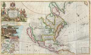
To His Grace Hugh, Lord Archbishop of Armagh, Primate and Metropolitan of all Ireland and One of the Lords Justices of the said Kingdom this map of North America According to the Newest and most Exact Observations is most humbly Dedicated by your Graces most humble Serv: Geo: Grierson.
sold
- Digital Map Information
- Suitable for large format printing
- Full resolution TIFF file
- ICC color profile embedded
- Delivered instantly via download link
An antique map discovery of the utmost rarity. Ostensibly, this is a fine example of Hermann MollÂ's important and highly desirable 1720 Codfish Map, entitled 'To the Right Honourable John Lord Sommers...' Upon closer inspection however, an entirely different ... (more details)
One of George Grierson's exceptional piracies of the English Pilot maps!
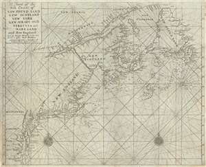
A Chart of the Sea Coast of New Found Land, New Scotland, New York, New Jersey, with Virginia and Maryland and New England.
sold
- Digital Map Information
- Suitable for large format printing
- Full resolution TIFF file
- ICC color profile embedded
- Delivered instantly via download link
This is George Grierson's 1749 Dublin piracy of the English Pilot nautical chart or maritime map covering the eastern coast of North America from Cape Henry to the Mouth of the St. Lawrence. Grierson's piracies were issued contemporaneously with their sources ... (more details)
Scarce Grierson's Piracy of Tiddeman's important map of New York City and Harbor.
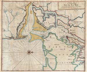
A Draught of New York from the Hook to New York Town.
sold
- Digital Map Information
- Suitable for large format printing
- DPI: 300
- File Size: 18.87 MB
- File Type: ZIP / TIFF
- ICC color profile embedded
- Delivered instantly via download link
A scarce and impressive colonial period 1749 George Grierson / Mark Tiddeman nautical chart of New York City and harbor. Oriented to the west and centered on Coney Island (Cunny I.), Grierson's chart covers from Staten Island to Jamaica Bay and from Sandy Hook ... (more details)