
Hankow Daily News (sold)

Hankow Daily News (March 15, 1906 - c. 1912) was an English language newspaper published in Hankow in the early 20th century. The newspaper's first issue was released in March of 1906. The paper was founded by the English China coast merchant John Andrew and the German expatriate Otto Marx, who important type and a large press form England. It promised to offer the latest news from British, American, and German telegraph wires as well as local news collected from missionaries in the Yangtze valley. Andrews died in 1907 or 1908 and Marx died shortly 1908, after which ownership and editorship fell to T. Ross-Reid. The paper, among other political positions, advocated for a consolidated International Settlement (like Shanghai) and covered the First Chinese revolution (1911) and the Battle of Hankow from a first person perspective. It consisted of roughly 8 pages, each organized into to 6 columns, with occasional supplements. Publication appears to have ceased around 1912, following the Xinhai Revolution.
Only known example. The 1911 burning of Hankow and reconstruction plans.
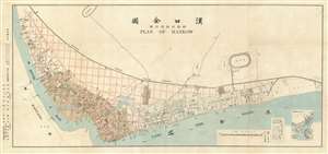
漢囗全圖 / Complete Map of Hankou. / 附新市街設計圖 / Attached Map of New City Street Design.
sold
- Digital Map Information
- Suitable for large format printing
- File Size: 26.55 MB
- File Type: ZIP / TIFF
- ICC color profile embedded
- Delivered instantly via download link
This is a rare 1912 Chinese-English bilingual map of Hankow (Hankou), part of modern Wuhan, China. The map was issued by the English-language Hankou based newspaper, Hankow Daily News, shortly following the 1911 burning of Hankou by Qing loyalist forces during the Xinhai Revolution (October 18 - December 1, 1911). Oriented to the northwest, the map covers from the conjunction of the Han and Yangtze Rivers northward to the tracks of the Hankow-Peking Railway or Jinghan Railway (京漢鐵路). The map labels the foreign concessions established to the east of the older Chinese city of Hankou, among them British, Russian, French, German, and Japanese. The lands to the west of the concessions are overprinted with a grand grid structure in red - reflecting plans to rebuild the Chinese part of Hankou after its total immolation one year earlier. (more details)