
Hausermann, Rémy (sold)

Rémy Hausermann (1843 - 1933) was a French map engraver who, among other roles, was the main engraver for the Missions Catholiques de Lyon, allowing him to introduce the geography of areas previously little known or unknown to a European audience. Little is known about his early life and training, but by 1879 he was the Vice President of the Congrès des Sciences géographiques. He was well-known and well-regarded in geographical study circles in the late 19th century, writing school textbooks on the subject and receiving accolades at the 1878 exposition universelle in Paris.
Missionary Mapping of East Africa.
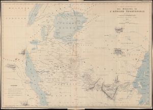
Carte partielle des Missions de l'Afrique Équatoriale.
sold
- Digital Map Information
- Suitable for large format printing
- File Size: 17.17 MB
- File Type: ZIP / TIFF
- ICC color profile embedded
- Delivered instantly via download link
An interesting map of 'Equatorial Africa' by the French missionary Félix Charmetant, taking in parts or the entirety of the present-day countries of Tanzania, Kenya, Uganda, Rwanda, Burundi, and the Democratic Republic of the Congo. Charmetant traces the routes of recent French missionary expeditions (which he helped plan) and provides an overview of regional geography, hitherto little known to Europeans. (more details)
First cartographic reconnaissance of the Chao Phraya River.
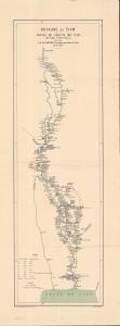
Royaume de Siam Cours du fleuve Me-Nam (Mè Năm Chào Phăja).
sold
- Digital Map Information
- Suitable for large format printing
- File Size: 13.53 MB
- File Type: ZIP / TIFF
- ICC color profile embedded
- Delivered instantly via download link
An important 1879 Émile Lombard missionary map of the Chao Phraya River, Thailand (Siam). It is significant as the first major upgrade to Siamese inland cartography since the 1828 John Crawfurd Map (SoutheastAsiaSiam-crawfurdwalker-1828-3). It is the first map to accurately identify towns and villages along the Chao Phraya, and the first we are aware of to use the term 'Chao Phraya'. It is of note that, while in most cases we would emphasize this work as the 'first European mapping' of the region, in this case, indigenous Siamese mapmaking is extremely limited and practically unknown until the 20th century, so this work marks the first time most of these villages appeared in any cartographic context. (more details)
France's 'Civilizing Mission' in Madagascar.
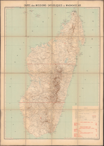
Carte des Missions Catholiques à Madagascar Supplément au Journal les Missions Catholiques, 1903.
sold
- Digital Map Information
- Suitable for large format printing
- File Size: 48.67 MB
- File Type: ZIP / TIFF
- ICC color profile embedded
- Delivered instantly via download link
This is a large-format 1903 folding map of Madagascar, prepared by Rémy Hausermann for the missionary publication Les Missions Catholiques. It was produced as Catholic missionaries were dramatically expanding their footprint in Madagascar and leading the effort to eradicate the island's long-entrenched practice of slavery. (more details)