
Heymann, Ignaz (sold)

Ignaz Heymann (1765-1815) was an Austrian postmaster, publisher, and cartographer active in Italy during late 18th and early 19th century. Heymann was born in Karansebes (modern day Romania). At age 7 he moved with his parents to Milan where, as a young man, he attended the Jesuit College of Brera. In 1874 he traveled throughout Italy, visiting Florence, Rome, Naples, and Venice, finally landing in Gorizia, where he took a job with the local tax regulatory commission. Afterwards he relocated to Trieste where he found work with the Postal Service. The Napoleonic occupation of Trieste in 1809 forced him to move again, this time to Vienna, where he again took work with the postal service. He retired from the postal service in 1811, after 25 years of service. For his distinguished civil service to the Hapsburg Empire he was awarded the Große Goldene Civil-Verdienstmedaille (Great Golden Civil Merit Medal). He published a number of large format maps, most associated with the postal service. His earliest cartographic studies appeared in 1797. Numerous maps followed, most depicting various parts of the Hapsburg Empire and Italy. Heymann died in 1815.
An exquisite large-format map of Italy made during the French Revolutionary Wars.
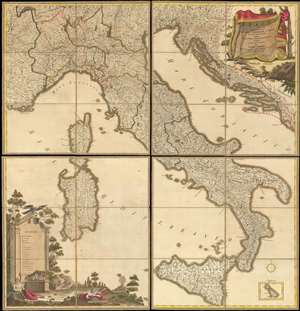
Italia cioè tutte le grandi e picciole Sovranità e Republiche d'Italia divise nelli nuovi loro Confini, comrese le Strade pubbliche, le Stazioni di posta e loro distanze Disegnata secondo le più recenti notizie.
sold
- Digital Map Information
- Suitable for large format printing
- DPI: 600
- File Size: 135.81 MB
- File Type: ZIP / TIFF
- ICC color profile embedded
- Delivered instantly via download link
A beautifully executed 1799 Ignaz Heymann old-color wall map of Italy sectionalized and laid down on linen. Depicting Italy in full, the map covers from Toulon, France to Montenegro and from Lausanne, Switzerland to Sicily. The map captures Italy at the beginning of the War of the Second Coalition (1799 - 1800), fought between the European monarchies and Revolutionary France. Chronicled here are nearly all the battles of the War of the First Coalition (1792 - 1797), each of which is marked by a pair of crossed swords. Fought around the cities of Lodi, Manua, Mondovì, Codogno, Rovereto, and Bassano, among others, almost all were resounding French victories over the opposing Piedmontese and Austrian armies. (more details)
Highly decorative wall sized map of Italy.
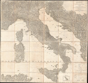
Italia Divisa ne' suoi Presenti Confini.
sold
- Digital Map Information
- Suitable for large format printing
- DPI: 300
- File Size: 52.74 MB
- File Type: ZIP / TIFF
- ICC color profile embedded
- Delivered instantly via download link
A beautifully engraved 1815 large format postal map of Italy by the Austrian cartographer Ignaz Heymann. This remarkable map covers from Lake Geneva to Sicily and from Toulon to Corfu, covering in the process all of Italy, Sardinia, Corsica, and Sicily, as well as ... (more details)