
Imprimerie Alfred Karcher (sold)

The Imprimerie Alfred Karcher (1911 - 1999) was a French publishing firm founded by two Alsatian brothers,Jules and Alfred Karcher, in the 10th arrondissement of Paris.
Charming pictorial map promoting Cameroon.
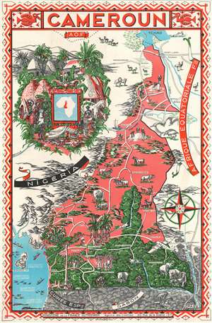
A Map of Cameroun.
sold
- Digital Map Information
- Suitable for large format printing
- File Size: 97.65 MB
- File Type: ZIP / TIFF
- ICC color profile embedded
- Delivered instantly via download link
This is a 1951 Léon Craste pictorial map of Cameroon, created for the French Ministère de la France Outre-Mer (Ministry of Overseas France). Coverage extends from French West Africa and Nigeria to French East Africa and from Lake Chad to Gabon and Spanish Guinea. Elephants, rhinos, lions, and hippos, some of the most recognizable animals in the world, are included, adding to the exotic aesthetic. This aesthetic, however, is encapsulated by the depiction of a native village in the upper left. Partially clothed natives stand staring at the 'camera' going about their daily activities surrounded by 'everyday' African objects, including a lion-skin rug and two elephant tusks. Huts and a lush green forest complete the vision. Exoticism had always been an important part of French promotion of the colonies, with a particularly good example being the 1931 Colonial Exposition in Vincennes. (more details)
A charming French pictorial map of French West Africa.
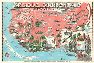
This is a 1951 Léon Craste pictorial map of French West Africa. The map depicts the region from the Atlantic Ocean to Chad and Cameroon in French Equatorial Africa and from Algeria to the Gulf of Guinea. French West Africa is shaded a dark salmon color and includes the colonies of Mauritania, French Sudan, Senegal, the Ivory Coast, French Guinea, Dahomey, Upper Volta, and Niger. Not only are the French colonies in West Africa identified, but so are Portuguese Guinea (modern-day Guinea-Bissau), Gambia (then a British colony and protectorate, today the independent nation of The Gambia), the Gold Coast (then a British colony, today the independent nation of Ghana), Togo, Liberia, Sierra Leone, and Nigeria. Cities throughout the region are identified, including Ouagadougou (the capital of Burkina Faso) and Timbuktu, both of which are marked by city views. Accra, Lagos, Abidjan, Freetown, Monrovia, Dakar, Bamako, and Djenne are also labeled. Both the Senegal River and Niger River are illustrated. Craste evokes the contrast in landscapes between the upper portion of the map, home to nomads, camel trains, and oases, with the lower portion, where lush jungles abound. Animals, both domestic and wild, are drawn, with lions, giraffes, and elephants appearing. Ships ply the waters of the Atlantic among whales and sharks. An inset map in the lower right quadrant, set among stereotypical and racist imagery of an African village, situates French West Africa on the continent. (more details)