
James, Joseph Allen (sold)

Joseph Allen James (May 17, 1807 - March 27, 1882) was a bookseller, engraver, stereotype founder, and publisher active in Cincinnati in the early to late 19th century. He was born in Newark, New Jersey. His firm, J. A. James and Company was based at 1 Baker Street, between Walnut and Vine. Additionally, he partnered with his brother, Uriah Pierson James (1811 - 1889) in 'J.A. and U.P. James Company', also a stereotype foundry. He was also a partner in the printing concern 'James and Gazlay'. James died at Fort Monroe, Virginia in 1882.
On the eve of the Texan Revolution...
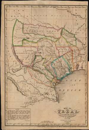
Map of Texas, containing the latest Grants and Discoveries by E. F. Lee.
sold
- Digital Map Information
- Suitable for large format printing
- Full resolution TIFF file
- ICC color profile embedded
- Delivered instantly via download link
The rare 1836 Edmund F. Lee map of Texas and accompanying History of Texas by David Barnett Edward - a seminal work published on the eve of the March 1836 Texan Revolution and founding of the Republic of Texas. The map is loosely derived from the Stephen Austin map, the only readily available source at the time, but has been reduced and revised by Lee for smaller format publication. It unveils Texas extending from the Sabine to the Nueces River and from Corpus Christi to the Red River. A note in the lower left expresses the Texan ambition to extend the boundary west as far as the Rio Grande. The map notes several early Texas Empresario Land Grants, including: 'McMullen and McGlone', Woodbury, Cameron (2), 'Austin and Williams', Austin, DeWitt, Austin's Colony, De Leon, Burnet, Powers, Whelin, Zavallo, and Felisola. (more details)
On the eve of the Texan Revolution...
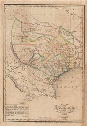
Map of Texas, containing the latest Grants and Discoveries by E. F. Lee.
sold
- Digital Map Information
- Suitable for large format printing
- DPI: 600
- File Size: 7.52 MB
- File Type: ZIP / TIFF
- ICC color profile embedded
- Delivered instantly via download link
The rare 1836 Edmund F. Lee map of Texas produced for David Barnett Edward's History of Texas - a seminal work published on the eve of the March 1836 Texan Revolution and founding of the Republic of Texas. The map is loosely derived from the Stephen Austin map, the only readily available source at the time, but has been reduced and revised by Lee for smaller format publication. It unveils Texas extending from the Sabine to the Nueces River and from Corpus Christi to the Red River. A note in the lower left expresses the Texan ambition to extend the boundary west as far as the Rio Grande. The map notes several early Texas Empresario Land Grants, including: 'McMullen and McGlone', Woodbury, Cameron (2), 'Austin and Williams', Austin, DeWitt, Austin's Colony, De Leon, Burnet, Powers, Whelin, Zavallo, and Felisola. (more details)