
Kandel, David (sold)

David Kandel (1520–1592) was a Renaissance artist, a pioneer of botanical and natural history illustration, and a prolific woodcut artist. His personal life is obscure. He is thought to have been born in Strasbourg, in 1520; He married in 1554 and 33 years later, in 1587, was recorded as "owner of a house". He died in 1592. His oeuvre was extremely broad, ranging from botanical illustrations to biblical events, largely as a product of his work as an illustrator. He produced about 550 of the superb woodcuts for Hieronymus Bock's 1546 Kreuterbuch (The Book of the Herbs). He produced many of the woodcuts appearing in Sebastian Münster's Cosmographia, including many of the maps and views, as well as his superb rendition of Dürer's sketch of a rhinoceros.
One of the Earliest Acquirable Views of Istanbul.
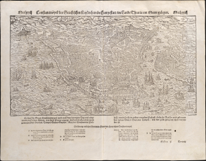
Constantinopel, des griechischen Keyserthumbs Hauptstatt im Landt Thracia am Meere gelegen.
sold
- Digital Map Information
- Suitable for large format printing
- Full resolution TIFF file
- ICC color profile embedded
- Delivered instantly via download link
This is Sebastian Münster's attractive, 1550 woodcut bird's-eye view map of Constantinople (Istanbul), one of the earliest acquirable. It displays the famous city in detail viewed from the east, emphasizing both its ancient ruins and its contemporary monuments, including the Hagia Sophia, the palace of Constantine, the Gynoecium, and the Ottoman Imperial Arsenal. The city's suburbs of Pera can be seen to the north on the right side of the view. The waters of the Bosporus are teeming with ships of every description. (more details)
Discovery Era World Revealed.
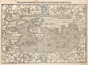
Das erst general inhaltend die beschreibung und den circkel des gantzen erdereichs und moeres.
sold
- Digital Map Information
- Suitable for large format printing
- DPI: 600
- File Size: 27.09 MB
- File Type: ZIP / TIFF
- ICC color profile embedded
- Delivered instantly via download link
This is Sebastian Münster's 1550 map of the world, one of the most distinctive maps produced during the Age of Discovery. In the mid-16th century, it was the best generally available summation of the rapidly expanding known world. The map was included in Münster’s magnum opus, Cosmographia Universalis, which for over 40 years was the go-to volume for the literate European seeking knowledge of the world. Consequently, this map had a disproportionate impact, providing a broad audience their first image of the post-Magellanic world. It was not challenged until the 1570 publication of Ortelius' Theatrum Orbis Terrarum. As important as its geographical revelations were, the map is also rich in the imagery of its era: it is bordered with billowing clouds and wind-heads marking the cardinal directions, puffing their breezes over the waters. The oceans are prowled by eight sea monsters and a sailing ship is shown crossing the Pacific and proudly firing its cannons. (more details)
Discovery Era World Revealed.
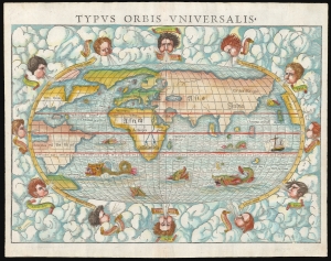
Typus Orbis Universalis.
sold
- Digital Map Information
- Suitable for large format printing
- Full resolution TIFF file
- ICC color profile embedded
- Delivered instantly via download link
This is Sebastian Münster's 1550 map of the world, one of the most distinctive maps produced during the Age of Discovery. In the mid-16th century, it was the best generally available summation of the rapidly expanding known world. The map was included in Münster's magnum opus, Cosmographia Universalis, which for over 40 years was the go-to volume for the literate European seeking knowledge of the world. Consequently, this map had a disproportionate impact, providing a broad audience with their first image of the post-Magellanic world. It was not challenged until the 1570 publication of Ortelius' Theatrum Orbis Terrarum. As important as its geographical revelations were, the map is also rich in the imagery of its era: it is bordered with billowing clouds and wind-heads marking the cardinal directions, puffing their breezes over the waters. Eight sea monsters prowl the oceans, and a sailing ship appears, crossing the Pacific and proudly firing its cannon. (more details)
The Circumnavigable Globe Revealed.
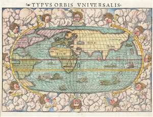
Typus Orbis Universalis.
sold
- Digital Map Information
- Suitable for large format printing
- Full resolution TIFF file
- ICC color profile embedded
- Delivered instantly via download link
This is Sebastian Münster's 1550 map of the world, one of the most distinctive produced during the Age of Discovery. In the mid-sixteenth century, it was the best summation of the rapidly expanding known world available to the literate European. The map was included in Münster’s magnum opus, Cosmographia Universalis, for over forty years was the primary source for anyone who wished knowledge of the world. Consequently, this map would have had a disproportionate impact, providing the first presentation of a circumnavigable world for nearly half a century. It would not be challenged until the 1570 publication of Ortelius' Theatrum Orbis Terrarum. As important as its geographical revelations were, the map is also rich in the imagery of its era: it is bordered with billowing clouds and wind-heads marking the cardinal directions, puffing their breezes over the waters. The oceans are prowled by eight sea monsters and a sailing ship is shown crossing the Pacific and proudly firing its cannons. (more details)
Discovery Era World Revealed.
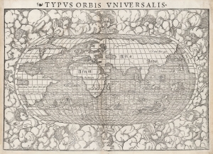
Typus Orbis Universalis.
sold
- Digital Map Information
- Suitable for large format printing
- DPI: 600
- File Size: 26.37 MB
- File Type: ZIP / TIFF
- ICC color profile embedded
- Delivered instantly via download link
This is Sebastian Münster's 1550 Typus Orbis Universalis, one of the most distinctive world maps produced during the Age of Discovery. In the mid-sixteenth century, it was the best generally available summation of the rapidly expanding known world. The map was included in Münster’s magnum opus, Cosmographia Universalis, which for over 40 years was the go-to volume for the literate European seeking knowledge of the world. Consequently, this map had a disproportionate impact, providing a broad audience their first image of the post-Magellanic world. It was not challenged until the 1570 publication of Ortelius' Theatrum Orbis Terrarum. As important as its geographical revelations were, the map is also rich in the imagery of its era: it is bordered with billowing clouds and wind-heads marking the cardinal directions, puffing their breezes over the waters. The oceans are prowled by eight sea monsters and a sailing ship is shown crossing the Pacific and proudly firing its cannons. (more details)