
Kellogg, Elijah Chapman (sold)

Elijah Chapman Kellogg (June 13, 1811 - December 13, 1881) was an American lithographer and engraver. Born in Tolland, Connecticut, Elijah trained as an engraver under his older brother Jarvis Griggs Kellogg (1805 - 1873). Then he joined his brother Daniel Wright Kellogg's (1807 - 1874) lithography firm D.W. Kellogg and Company. Daniel moved west in 1836, which meant Elijah and his brother Edmund Burke Kellogg (1809 - 1872) took over the firm. Elijah and Edmund renamed the firm E.B. and E.C. Kellogg in 1840, and operated that business until 1848, when John C. Comstock joined the partnership. With the addition of Comstock they renamed the firm Kellogg and Comstock, but that partnership lasted only until 1850. After the partnership with Comstock fell apart, the brothers went separate ways until 1855 when they reopened E.B. and E.C. Kellogg. Elijah's sone Charles B. Kellogg joined the firm in 1865. Elijah and Edmund sold their interest in the firm to William H. Bulkeley in 1867, and the younger Kellogg and Bulkeley formed a partnership named Kellogg and Bulkeley. This firm operated until 1946 when it merged with Case, Lockwood, and Brainard to form Connecticut Printers, Inc, which is still in operation today.
Rare map of Texas issued just before the Treaty of Guadeloupe Hidalgo.
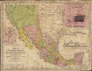
Map of Mexico, Texas, Old and New California, and Yucatan. Showing the principal Cities and Towns, Travelling Routes and c.
sold
- Digital Map Information
- Suitable for large format printing
- Full resolution TIFF file
- ICC color profile embedded
- Delivered instantly via download link
The only known example of the 1848 edition of House and Brown's broadside map of Texas, Mexico, and Upper California, issued at the end of the Mexican-American War (1846 - 1848). The map is centered on Texas, which is presented at its largest, with its western border embracing Albuquerque and Santa Fe, and the stovepipe configuration extending its northern border to 42° N latitude. The map is elaborated by inset maps of Monterey illustrating the Battle of Monterrey (September 21 - 24, 1846) and Veracruz, Mexico. In addition, the Gulf of Mexico is occupied by a large vignette view of the fortress of San Juan de Ulúa, Veracruz. In this edition, Texas is uncolored, emphasizing that it is part of the United States, but Upper California and New Mexico are colored as Mexican intendencias, suggesting this map predates the Treaty of Guadalupe Hidalgo and must therefore have been sent to the presses sometime before February 28, 1848. (more details)