
Kurz, Louis (sold)

Louis Kurz (1854 - 1942) was a Swiss professional musician and a mountaineer. Born in Neuchâtel, Switzerland, Kurz was the author of the excellent Guide de la Chaîne du Mont Blanc, which was published in 1892. He explored throughout the region and was known for his work as a surveyor.
The finest 19th century map of the Mont Blanc Range.
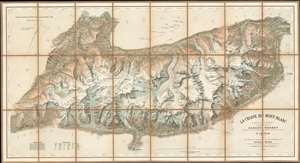
Le Chaine du Mont-Blanc.
sold
- Digital Map Information
- Suitable for large format printing
- File Size: 50.21 MB
- File Type: ZIP / TIFF
- ICC color profile embedded
- Delivered instantly via download link
Generally known as 'The Imfeld Map', this is a dramatic and stunning 1896 Xaver Imfeld chromolithograph map of the Mont Blanc Mountain Range in Switzerland's Alps - at the time the finest map of the region yet produced. The map is oriented slightly to the northwest and is centered on the peak of Mont Blanc itself. Coverage extends from Bon-Nant River in France to Orsières and from Gillot to Courmayeur. The map was highly praised when it was produced by journals of the time,
To this faultless production all explorers of the Chian are deeply indebted, and for the first time the Mont du Brouillard, the Glacier du Mont Blanc, the Rochers du Mont Blanc, the Glacier du Dôme, and the Aiguilles Grises are all beautifully delineated with scrupulous fidelity to nature. (Mathews, C. E., Annals of Mont Blanc, page 216)The whole employs the unique Swiss-style shading techniques employed by the engraver, Kümmerly, to display that country's intense topography. (more details)