
Langhans, Paul Max Harry (sold)

Paul Max Harry Langhans (April 1, 1867 - January 17, 1952) was a German cartographer and geographer. Langhans was born in Hamburg, the son of an innkeeper. He attended secondary school from 1878 to 1886 in Hamburg. Then, in Kiel and Leipzig from 1886 to 1889, studied natural sciences, economics, and geography. He started working for Justus Perthes's Geographisch-kartographischen Anstalt in 1889 and created maps and atlases for the company during the following decades. Langhans worked as the editor of Petermanns Geographische Mitteilungen from 1909 until 1937 and was the editor-in-chief of Gothaischer Hofkalender beginning in 1923. Considered to be one of the most important German representatives of ethnocentric geopolitics, Langhans, founded the magazine Deutsche Erde in 1902, which supported folk and cultural soil research and was close to the Pan-German Association. He was a member of the German Social Reform party, an anti-Semitic political party, and worked as editor of the Antisemitic Monthly Gazette from 1896 to 1907. IN 1931, Langhans joined the National Socialist German Workers' Party (NAZI). He worked as a training speaker in Schönau vor dem Walde at the NSDAP district school. He was married to Rosa Langhans (born Rasch, 1870 - 1960) with whom he had a daughter.
The Scramble for Africa.
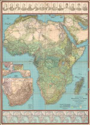
Justus Perthes' Wandkarte von Afrika zur Darstellung der Bodenbedeckung mit 8 Kärten zur Entdeckungsgeschichte und 14 Bildnissen berühmter Afrikaforscher.
sold
- Digital Map Information
- Suitable for large format printing
- Full resolution TIFF file
- ICC color profile embedded
- Delivered instantly via download link
This is a 1906 Paul Langhans wall map of Africa made at the height of the Scramble for Africa, when European nations vied for influence and colonies across the vast resource-rich continent. The map highlights European exploration in Africa's in the 19th century. Portraits of fourteen European explorers of Africa, including Henry Stanley, David Livingstone, and Mungo Park, occupy the top portion of the map. Eight smaller maps along the bottom border trace their routes across the continent. Like much of Langhans' work, this map is educational, but the content can also be understood in the light of his ardently held belief that Europeans, and in particular Germans, held an inherent right to hegemony over non-European peoples. (more details)