
Mulford, John Cheeseman (sold)

John Cheeseman Mulford (April 27, 1876 - March 15, 1933) was an American cartographer active in the early to middle 20th century. He was born in Winnetka, Illinois. As early as 1918, Mulford worked in the drafting section of the Washington D.C. office of the Bureau of Reclamation, a federal water resource management agency. Mulford was later the chief cartographer of the National Highways Association (NHA). He played a significant role in mapping the early development of the American highway system. Mulford died in Maryland in 1933.
Rare persuasive map made to promote the constrution of the U.S. Highway System!
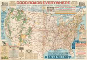
Good Roads Everywhere.
sold
- Digital Map Information
- Suitable for large format printing
- File Size: 98.5 MB
- File Type: ZIP / TIFF
- ICC color profile embedded
- Delivered instantly via download link
A scarce, large, and strikingly dense 1926 persuasive map of the United States prepared to promote federal investment in a national highway system. The map covers the United States from Coast to Coast and from Canada to Mexico. Highways are illustrated with color coding defining the 250,000 miles of national highways advocated for by the National Highway Association. These include the NHA's darling project, the National Park-to-Park Highway connecting the National Parks in the western United States. The map also includes arguments for the construction of 'Highway Airports.' (more details)
Rare persuasive map made to promote the constrution of the Canadian Highway System!
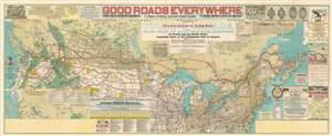
Good Roads Everywhere. Trans-Canada Highway.
sold
- Digital Map Information
- Suitable for large format printing
- File Size: 69.01 MB
- File Type: ZIP / TIFF
- ICC color profile embedded
- Delivered instantly via download link
A scarce, large, and strikingly dense 1928 National Highways Association persuasive map of the southern Canada prepared to promote investment in a Canadian national highway system. Entitled 'Good Roads Everywhere' the map was is a modified version of a similar map issued in 1926 to promote highways in the United States. The map covers southern Canada and the northern part of the United States from Coast to Coast. Highways are illustrated with color coding defining the 75,000 miles of Canadian highways advocated for by the National Highway Association. (more details)