
Müller, Johann Christoph (sold)

Johann Christoph Müller (March 15, 1673 - June 21, 1721) was a German cartographer, military engineer, and astronomer. Having been schooled in the humanities, he was then trained in mathematics and drawing by astronomer and engraver G. C. Eimmart. Beginning in 1696, he served as an officer of the Engineer Corps, carrying out astronomical observations in and around Vienna, and conducting surveys. Following the 1699 treaty of Karlowitz he was appointed to collect data for an accurate map of Hungarian territory. This resulted in a map drawn to 24 sheets, the original of which survives in the Cartographic Collection of the National Library in Vienna, with a complete copy in War Archives in Vienna. He would in 1709 produced a large map of Hungary along with Croatia, Slavonia, and Transylvania. Between 1708 and 1712 he surveyed Moravia by county and in 1720 published a four sheet copperplate map of Moravia, and produced a survey of Bohemia; this 25 sheet Mappa geographica Regni Bohemia was published posthumously in 1722.
Marking the New Borders with the Ottoman Empire.
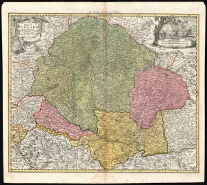
Regni Hungariae tabula generalis ex archetypo Mülleriano SCM capit. et ing.
sold
- Digital Map Information
- Suitable for large format printing
- DPI: 600
- File Size: 73.65 MB
- File Type: ZIP / TIFF
- ICC color profile embedded
- Delivered instantly via download link
This is Johann Baptist Homann's 1724 map of the Kingdom of Hungary, based on the comprehensive 1699 surveys of Johann Christoph Müller. These were undertaken to measure the bounds of Hungary following the Ottoman Empire's surrender at the treaty of Karlowitz. Consequently, this represented the new frontier with the Ottoman Empire following the treaty. (more details)