
Petruccelli, Antonio (sold)

Antonio Petruccelli (1907-1994) began his career as a textile designer. Petruccelli became a freelance illustrator in 1932 after winning several House Beautiful cover illustration contests. His work eventually appeared on the covers of Fortune, The New Yorker, Collier’s Today and House Beautiful magazines. ‘Tony was Mr. Versatility for Fortune. He could do anything, from charts and diagrams to maps, illustrations, covers, and caricatures,’ said Francis Brennan, the art director for Fortune. Over the course of his career, Petruccelli won several important design awards. Antonio Petruccelli died at age 87 on November 11, 1994.
Includes an illustration of the Grand Coulee Dam, which was under construction at the time.
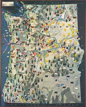
[Pictorial Map of the States of Washington and Oregon].
sold
- Digital Map Information
- Suitable for large format printing
- File Size: 40.16 MB
- File Type: ZIP / TIFF
- ICC color profile embedded
- Delivered instantly via download link
Brimming with charm, this 1940 Antonio Petruccelli pictorial map of Washington and Oregon promotes the region's agricultural, mineral, and natural wealth while also highlighting its technological advancements. Pictorial icons illustrate cattle, roosters, pigs, and sheep, as well as wheat, apples, cherries, and other fruits. Icons of miners, lumber, and paper indicate industrial areas, while fishermen emphasize one of the region's most popular leisure activities. Profiles of Native Americans mark Indian reservations. The Grand Coulee Dam (under construction when this map was published) and the Bonneville Dam both underline the exploitation of the region's natural resources. Cities and towns throughout the two states are identified, as are state universities and national parks. Mountain peaks are also labeled, along with rivers, and roads. (more details)
Depicts the 'Great Circle' - verso covered in military aviation information.
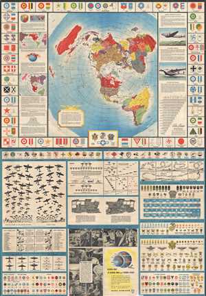
Global Map for Global War and Global Peace.
sold
- Digital Map Information
- Suitable for large format printing
- File Size: 42.55 MB
- File Type: ZIP / TIFF
- ICC color profile embedded
- Delivered instantly via download link
This is a 1943 Antonio Petruccelli and Aluminum Company of America map of the world. The map utilizes the Azimuthal Equidistant Projection, or the North Pole Projection. Created with the purpose of illustrating true distances traveled by air, this projection allows ... (more details)
Depicts the 'Great Circle' - verso covered in military aviation information.
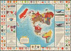
Global Map for Global War and Global Peace.
sold
- Digital Map Information
- Suitable for large format printing
- File Size: 58.88 MB
- File Type: ZIP / TIFF
- ICC color profile embedded
- Delivered instantly via download link
This is a 1943 Antonio Petruccelli and Aluminum Company of America map of the world. The map utilizes the Azimuthal Equidistant Projection, or the North Pole Projection. Created with the purpose of illustrating true distances traveled by air, this projection allows ... (more details)
Depicts the 'Great Circle' - verso covered in military aviation information.
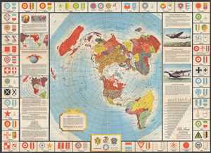
Global Map for Global War and Global Peace.
sold
- Digital Map Information
- Suitable for large format printing
- File Size: 21.52 MB
- File Type: ZIP / TIFF
- ICC color profile embedded
- Delivered instantly via download link
This is a 1943 Antonio Petruccelli and Aluminum Company of America map of the world. The map utilizes the Azimuthal Equidistant Projection, or the North Pole Projection. Created with the purpose of illustrating true distances traveled by air, this projection allows ... (more details)
Depicts the 'Great Circle' - verso covered in military aviation information.
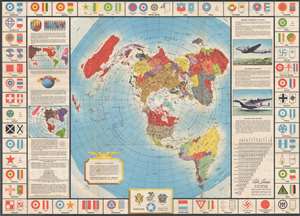
Global Map for Global War and Global Peace.
sold
- Digital Map Information
- Suitable for large format printing
- File Size: 22.66 MB
- File Type: ZIP / TIFF
- ICC color profile embedded
- Delivered instantly via download link
This is a 1943 Antonio Petruccelli and Aluminum Company of America map of the world. The map utilizes the Azimuthal Equidistant Projection, or the North Pole Projection. Created with the purpose of illustrating true distances traveled by air, this projection allows ... (more details)
Depicts the 'Great Circle' - verso covered in military aviation information.
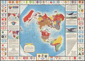
Global Map for Global War and Global Peace.
sold
- Digital Map Information
- Suitable for large format printing
- File Size: 21.14 MB
- File Type: ZIP / TIFF
- ICC color profile embedded
- Delivered instantly via download link
This is a 1943 Antonio Petruccelli and Aluminum Company of America map of the world. The map utilizes the Azimuthal Equidistant Projection, or the North Pole Projection. Created with the purpose of illustrating true distances traveled by air, this projection allows ... (more details)
An American political cartoon promoting American victories in the Pacific War against Imperial Japan during World War II.
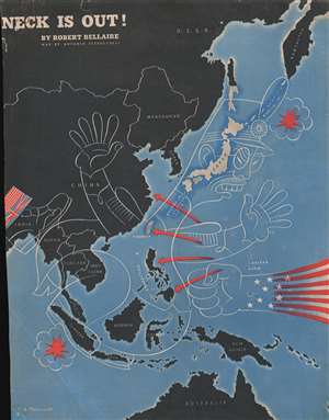
Neck Is Out!
sold
- Digital Map Information
- Suitable for large format printing
- File Size: 9.15 MB
- File Type: ZIP / TIFF
- ICC color profile embedded
- Delivered instantly via download link
This is a 1944 Antonio Petruccelli political cartoon map of East Asia and the Pacific during World War II. The map depicts the region from India to the Central Pacific and from the Soviet Union to Australia. Everything is colored black except for Japan, Formosa (Taiwan), and the Kurile and Ryukyu Islands. Meant to emphasize American and Allied gains in the Pacific Theater, a 'Star-Spangled' fist, representing the U.S. military, is delivering body blows to an incredibly racist caricature of a Japanese officer, while a joint British and American foot is pushing from behind in India and Burma. (more details)