
Howell, Reading (sold)

Reading Howell (1743 - 1827) was a Pennsylvania based engineer, landowner, and surveyor active in the late 18th and early 19th century. While little is known of his personal life, records do survive of his surveying projects, including detailed surveys of the Delaware, Lehigh, and Schuylkill Rivers. In 1789 he was commissioned by the assembly of Pennsylvania to, for the sum of two hundred pounds, to produce a detailed map of the state. This map, which was initially published in 1792, was the first map of Pennsylvania to be issued following the American Revolutionary War. This important document would prove to be the finest and most important map of Pennsylvania to be issued to date, incorporating, as it did, the wealth of cartographic information generated by both American and British military surveyors during the Revolution. From 1804 to his death in 1827, Howell held the title of "Principal City Surveyor" as well as "City Regulator" of Philadelphia, where his name is attached to numerous surveys related to land disputes.
The earliest map of Pennsylvania published in the American Republic.
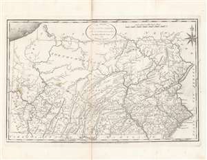
The State of Pennsylvania : reduced with permission from Reading Howell's map.
sold
- Digital Map Information
- Suitable for large format printing
- DPI: 600
- File Size: 35.23 MB
- File Type: ZIP / TIFF
- ICC color profile embedded
- Delivered instantly via download link
This is a fine first state example of Samuel Lewis’ 1795 map of Pennsylvania for Carey's General Atlas, the first atlas published in the young American Republic. It was an especially significant map as the producers of the atlas were based in Philadelphia, also the nation’s (temporary) capital at the time, which they used as the Prime Meridian throughout the atlas. (more details)
A cartographic landmark in the mapping of Pennsylvania.
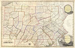
A Map of the State of Pennsylvania by Reading Howell MDCCCXI.
sold
- Digital Map Information
- Suitable for large format printing
- DPI: 300
- File Size: 25.69 MB
- File Type: ZIP / TIFF
- ICC color profile embedded
- Delivered instantly via download link
This map, which was first issued by Reading Howell in 1791, is considered to be one of the most important maps of Pennsylvania ever issued as well as the finest of the 18th century. Howell, a landowner and surveyor of Pennsylvania, was commissioned by the ... (more details)