
Schouani, Rodolphe (sold)

Rodolphe Schouani (17?? - April, 1809), also occasionally spelled Schouany, was a French topographical engineer active in the late 18th century. He is most famous as one of the 'Savants', scholars who accompanied the Napoleonic invasion of Egypt (1798 - 1801). During this time his work make him a pioneer in the emerging field of Egyptology. From 1805 he was assigned to complete a survey of Piedmont, but he died before completing it. It is recorded that Schouani had a very exacting but obscure method of surveying such that, when he died, his subordinates were unable to complete the survey of Piedmont as they could not understand his journals. It has been argued that Schouani was deeply suspicious of his superiors and so, embraced a eccentric methodology to protect his position by making him indispensable.
Best 19th century map of the Nile Valley near Aswan.
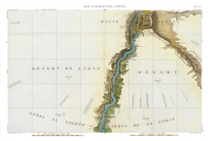
Flle. 1ere. Cataractes Syene Aswan (Carte topographique de l'Egypte et de plusieurs parties des pays limitrophes...)
sold
- Digital Map Information
- Suitable for large format printing
- Full resolution TIFF file
- ICC color profile embedded
- Delivered instantly via download link
This is a stunning 1817 map of the Nile Valley at Aswan, Egypt, one of the great achievements of Napoleonic scientific cartography and the first sheet of the monumental survey prepared for the Description de l'Égypte. Based upon fieldwork undertaken during Napoleon's Egyptian Campaign (1798 - 1801), it records in extraordinary detail the Nile cataracts, the Temple of Philae, ancient ruins, villages, roads, and battle sites. Beyond its significance as one of the earliest scientific surveys of Upper Egypt, the map preserves a landscape that has largely ceased to exist: much of the territory mapped south of Aswan, including the ancient cataracts and countless archaeological sites, disappeared beneath the waters of Lake Nasser following the construction of the Aswan High Dam. (more details)
World's richest archeological landscape.
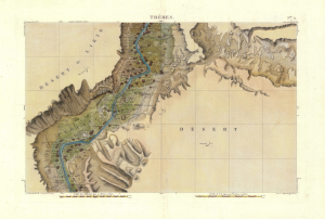
Flle. 5. Thebes. Carte topographique de l'Egypte et de plusieurs parties des pays limitrophes...)
sold
- Digital Map Information
- Suitable for large format printing
- Full resolution TIFF file
- ICC color profile embedded
- Delivered instantly via download link
An exceptionally detailed 1817 map of the Nile Valley at Luxor, ancient Thebes, documenting one of the richest archaeological landscapes in Egypt at the dawn of modern Egyptology. Centered on Luxor and the great monuments of Thebes, the map embraces both banks of the Nile, identifying ancient ruins, villages, roads, cultivated lands, and desert approaches with remarkable precision. It was compiled from surveys undertaken during Napoleon Bonaparte's Egyptian Campaign (1798 - 1801), when French military engineers and the celebrated Savants conducted the first systematic scientific survey of Egypt. Published as Sheet 5 of the monumental Description de l'Égypte, this map represents both a landmark of scientific cartography and an extraordinary record of the Theban landscape before nearly two centuries of excavation, development, and archaeological transformation. (more details)