
Scott, Joseph T. (sold)

Joseph T. Scott (fl. c. 1794 - 1811) was a Philadelphia-based publisher and engraver. Scott engraved many of the maps for Mathew Carey's Carey's American edition of Guthrie's Geography improved published in 1795. He also engraved maps that appeared in John Gibson's Atlas Minimus published in 1798.
The earliest map of the North Pacific published in the American Republic.
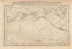
A map of the discoveries made by Capts. Cook and Clerke in the years 1778 and 1779...
sold
- Digital Map Information
- Suitable for large format printing
- DPI: 600
- File Size: 4.92 MB
- File Type: ZIP / TIFF
- ICC color profile embedded
- Delivered instantly via download link
This is a rare c. 1795 map of the northern Pacific Ocean from Carey's General Atlas, the first atlas published in the new American Republic. It highlights the three Pacific voyages of Captain James Cook and the overland route from Hudson's Bay to the Artic Ocean, 'discovered,' with critical help from indigenous guides, by Samuel Hearne. (more details)
One of the earliest specific maps of Tennessee.
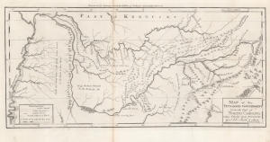
A Map of The Tennassee Government formerly Part of North Carolina taken Chiefly from Surveys by Genl. D. Smith and others.
sold
- Digital Map Information
- Suitable for large format printing
- Full resolution TIFF file
- ICC color profile embedded
- Delivered instantly via download link
This is a c. 1796 Mathew Carey map of the 'Tennessee Government', considered one of the earliest specific maps of Tennessee. (more details)