
Searle, Albert D. (sold)

Albert D. Searle (July 6, 1831 - October 20, 1902) was an American surveyor, civil engineer, and abolitionist active in Kansas in the middle part of the 19th century, during the 'Bloody Kansas' period. Searle was born in Southampton, Massachusetts. Searle moved to Lawrence Kansas on September 15, 1854, with the second part to emigrate to Lawrence, and helped to layout the townsite, completing the first survey of Lawrence. In 1856 he partnered with fellow Lawrence pioneer Edmund Burke Whitman (1812 - 1883) to establish a land agent and emigrant firm to encourage anti-slavery settlers to settle in Kansas. In conjunction with this effort he published an important 1856 map of Eastern Kansas. During the American Civil War (1861 - 1865) he was commissioned as a 2nd Lieutenant in the 9th Regiment Kansas Calvary, Company A, Union Army. After mustering out of service in 1865, he continued to live in Lawrence until about 1882, when he moved to Leadville Colorado to take up a position as head survey for the Denver - Silver Pumbe spur of the Denver and Rio Grande Railroad. Searle died in Leadville in 1902.
Bleeding Kansas map issued just one month after the Sack of Lawrence.
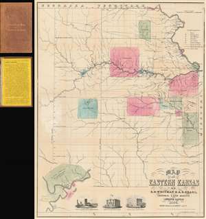
Map of Eastern Kansas.
sold
- Digital Map Information
- Suitable for large format printing
- File Size: 24.02 MB
- File Type: ZIP / TIFF
- ICC color profile embedded
- Delivered instantly via download link
An iconic and historically important map of Eastern Kansas during the 'Free Soil' and 'Bleeding Kansas' or 'Bloody Kansas' era, published just one month after the Sacking of Lawrence. This rare and important 1856 map by the prominent abolitionists Albert D. Searle, Edmund Burke Whitman, and John Punchard Jewett covers the eastern part of Kansas from the 6th Principal Meridian or 97° 22' 08'' W to the Missouri Border and the Missouri River, and from Nebraska to, roughly, the modern day northern border of Oklahoma. The map is intended to promote 'free state' emigration to Kansas as counterbalance to a similar effort by 'slave states' to move their own settlers into the territory. Zones highlighted with color reference American Indian lands - suggesting that emigrants avoid these territories and settle away from 'Indian troubles.' In the lower left there is an inset of Fort Riley on the Missouri River, identified as the 'Geographical Center of U. S. Possessions.' At the base are vignette illustrations of Constitution Hall in Topeka, and before and after images of Eldridge House, also known as the 'Free State Hotel,' which was burned to the ground by pro-slavery vigilantes. (more details)