
Service Géographique National (sold)

Service Géographique National (c. 1956 - 1990) was national mapping service established in Vientiane, Laos, following independence from France. The SGN was built upon the French Indo-Chinese Surveys, completed in the 1930s, and more modern surveys conducted with American assistance. In 1990 the service was redesignated as the 'National Geographic Department.'
Created by the French Service Géographique de l'Armée for French forces being sent to China to put down the Boxer Rebellion.
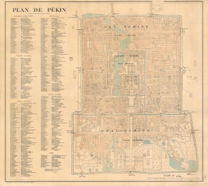
Plan de Pékin.
sold
- Digital Map Information
- Suitable for large format printing
- Full resolution TIFF file
- ICC color profile embedded
- Delivered instantly via download link
This is a 1900 Service Géographique de l'Armée city plan or map of Beijing / Peking, China, created for French soldiers sent to China as part of the Expeditionary Force to suppress the Boxer Rebellion. (more details)
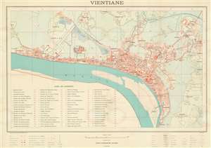
Vientiane.
sold
- Digital Map Information
- Suitable for large format printing
- File Size: 39.8 MB
- File Type: ZIP / TIFF
- ICC color profile embedded
- Delivered instantly via download link
This is a scarce 1961 large format city plan or urban map of Vientiane, Laos executed by the Service Géographique National at the height of the 'Secret' Laotian Civil War (1959 - 1975) and the Laos Crises (1961 - 1960). This is an official map constructed for administrative purposes following the 1954 Laotian independence from France. Highly detailed, the map covers all of Vientiane as it hugs the northern shore of the Mekong River, from Sibounhuang to Khouakhao. It extends northeast to include Ponkheng, the police school, and Thatlouang. In the old town center, a numeric key identifies some 48 government offices, foreign embassies and consulates, and public buildings. (more details)