
Stevens, Benjamin Franklin (sold)

Benjamin Franklin Stevens (February 19, 1833 – March 5, 1902), was a bibliographer and for about thirty years before his death was the US despatch agent at London. Stevens was born Barnet, Vermont and studied at the University of Vermont, where he was a member of the Sigma Phi society. In the 1840s he joined his more famous brother, Henry Stevens, to London where he worked as a book exporter. He started his own firm in partnership with Henry J. Brown in 1864. The firm operated as B. F. Stevens & Brown Literary and Fine Arts Agents. He spent some 30 years in London preparing and chronological and alphabetical index of American state papers in European archives and issued numerous facsimiles of important American historical documents. In addition, he worked as a purchasing agent for various American libraries. He died at Surbiton, Surrey, England, on the 5 March 1902. He is buried at Kensal Green Cemetery, London
The only published version of the Revolutionary War British manuscript headquarters map of New York City. Staggeringly huge and extremely rare!
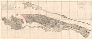
B. F. . Stevens's Facsimile of the Unpublished British Head Quarters Colored Manuscript Map of New York & Environs (1782) Reproduced from the Original Drawing in the War Office, London.
sold
- Digital Map Information
- Suitable for large format printing
- Full resolution TIFF file
- ICC color profile embedded
- Delivered instantly via download link
Quite a remarkable discovery of exceptional size, beauty, and rarity. This gigantic Revolutionary War Era map of New York City is the only published facsimile the the great manuscript map of New York City and environs that hung in the British Command Headquarters ... (more details)
Governor Stevens map of the proposed northern route of the Transcontinental Railroad.
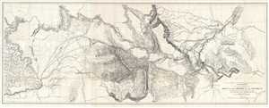
Explorations and Surveys for a Rail Road Route from the Mississippi River to the Pacific Ocean. War Department. Routes near the 47th and 49th Parallels. Milk R. to the Crossing of the Columbia R.
sold
- Digital Map Information
- Suitable for large format printing
- File Size: 33.43 MB
- File Type: ZIP / TIFF
- ICC color profile embedded
- Delivered instantly via download link
This is an 1855 Isaac I. Stevens map of the explorations to discover a proposed northern route of the transcontinental railroad. Carl I. Wheat considers this map so significant that he illustrates it in full. The map depicts from the Yellowstone River in Wyoming ... (more details)