
Stöcklein, Joseph [Stoecklein]

Joseph Stöcklein [Stoecklein] (July 30, 1676 – December 28, 1733) was a Jesuit priest, missionary, and scholar active in the late 17th and early 18th centuries. He was born in Oettingen, Germany and joined the Jesuit order in Vienna around 1700. He served as a priest in military encampments where he became popular as a preacher. Afterwards he became the head of the Jesuit library in Graz, Switzerland, a position he maintained for six years. During this tenure he began work on his opus, the Welt-Bott, a vast compilation of Jesuit missionary letters and narratives translated into vernacular German intended both to glorify the priesthood and share valuable information about the world. Today this work is exceedingly rare.
Seminal Map of the Beni, Boliva.
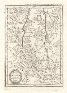
Mission bey den Moschen durch die IESUiter von Peru Gestifft.
$350.00
Acquire
- Digital Map Information
- Suitable for large format printing
- File Size: 2.53 MB
- File Type: ZIP / TIFF
- ICC color profile embedded
- Delivered instantly via download link
This is an influential c. 1726 map of the Beni in Bolivia and surrounding areas, which appeared in Joseph Stöcklein's Der Neue Weltbott. Based on a c. 1713 manuscript map, it is a critically important map in the cartography of this part of South America, serving as the basis for later maps of the region for years afterwards. (more details)
Mash-up of indigenous and European cartography.
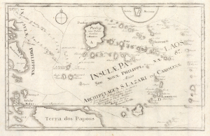
Insulae Palaos seu Novae Philippinae 87, alias Archipelagus S. Lazari vel Carolinae.
$1,200.00
Acquire
- Digital Map Information
- Suitable for large format printing
- File Size: 6.48 MB
- File Type: ZIP / TIFF
- ICC color profile embedded
- Delivered instantly via download link
This is a c. 1726 Joseph Stöcklein map of Palau and surrounding islands in the southwestern Pacific. This map is a fascinating mash-up of Europe and indigenous cartography. It is moreover an especially early presentation of these islands, based on a cartographic game of telephone from native Palauans waylaid in the Philippines through the Jesuits and then to the European public via Joseph Stöcklein. (more details)
Missionaries and the Mapping of the Western Pacific.
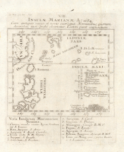
XIII. Insulae Marianae Ao. 1684 cum antiquis variis et novis sacrisque nominibus, quorum diversitas, nisi probé observateur, lectori parit confusionem.
$700.00
Acquire
- Digital Map Information
- Suitable for large format printing
- File Size: 4.31 MB
- File Type: ZIP / TIFF
- ICC color profile embedded
- Delivered instantly via download link
This is Joseph Stöcklein's c. 1726 map of the Mariana Islands and surrounding islands in the western Pacific. Among other features, it is notable for including the existence of islands posited by Father Paul Klein, Stocklein's fellow Jesuit, who developed early maps of this region based on his interactions with Palauan sailors. (more details)
Early look at Taiwan.
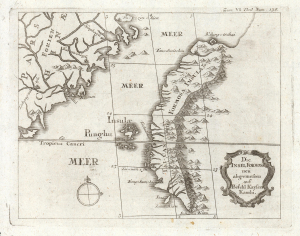
Die Insel Formosa neu abgemessen auf Befehl Kaysers Kamhi.
$1,450.00
Acquire
- Digital Map Information
- Suitable for large format printing
- DPI: 600
- File Size: 7.16 MB
- File Type: ZIP / TIFF
- ICC color profile embedded
- Delivered instantly via download link
This map is one of the earliest, if not the earliest, obtainable printed maps of Taiwan or Formosa Island. It appeared in Joseph Stöcklein's 1726 compilation of Jesuit missionary letters, which revealed much of what the Jesuit Fathers had learned of some of the remotest parts of the world. (more details)
Among the Earliest Detailed European Maps of Southern India.
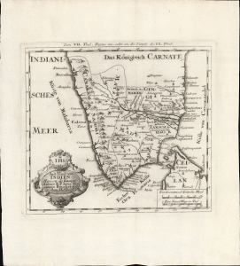
Sud-Theil von Indien Herwerts des Ganges.
$350.00
Acquire
- Digital Map Information
- Suitable for large format printing
- File Size: 8.03 MB
- File Type: ZIP / TIFF
- ICC color profile embedded
- Delivered instantly via download link
This is Jean-Venant Bouchet's c. 1728 map of southern India, published in Joseph Stöcklein's collection of missionary letters and accounts Allerhand so lehr-als geist-reiche Brief, Schrifften und Reis-Beschreibungen. It is among the earliest European maps to depict this part of the Subcontinent with reasonable accuracy. (more details)
Edition of the Earliest Map of the Amazon Produced by One Who Explored It.
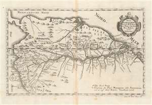
Strom Maragnon Autore R. P. Samuele Fritz, é Soc. Iesu. Prov. Bohem. 1707. Delineatus.
$500.00
Acquire
- Digital Map Information
- Suitable for large format printing
- Full resolution TIFF file
- ICC color profile embedded
- Delivered instantly via download link
This scarce 1728 Stöcklein map of the Amazon River is among the earliest acquirable maps based upon actual exploration to illustrate the full course of the Amazon River from the Andes to the Atlantic. The map is derived from the surveys of Samuel Fritz, a Czech Jesuit missionary who lived and worked in South America for over forty years. As a result of surveys intended to settle a border dispute, Fritz was able to determine the correct sources for the Marañón River, the primary source of the Amazon itself. The map shows forts, cities, and differentiates those cities with bishoprics and archbishoprics. Special notations on the map mark locations of the source of the Marañón 'as it is indicated on old maps,' and a further notation marks 'Die Insel Guar' in the middle of the Amazon. (more details)
Jesuit Foothold in the Chuanshan Archipelago.
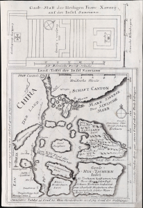
Land-Taffel der Insel Sanciano.
$750.00
Acquire
- Digital Map Information
- Suitable for large format printing
- File Size: 466.58 MB
- File Type: ZIP / TIFF
- ICC color profile embedded
- Delivered instantly via download link
This is the Joseph Stöcklein and Caspar Castner 1729 map of the south coast of China near Macau and Hong Kong. It highlights the Jesuit foothold on Shangchuan Island on the southern coast of Guangdong, China, dramatically overstating its size and proximity to Macao and Guangzhou, likely intentionally so that Stöcklein could incorporate additional detail. (more details)
Illustrates the Israelites crossing the Red Sea.
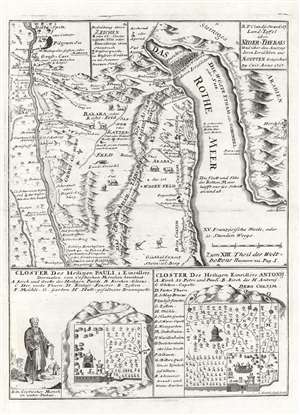
Land-Taffel über NIder-Thebais und über den Auszug deren Israëliten aus AEgypten.
$450.00
Acquire
- Digital Map Information
- Suitable for large format printing
- DPI: 600
- File Size: 11.42 MB
- File Type: ZIP / TIFF
- ICC color profile embedded
- Delivered instantly via download link
This is a c. 1728 Joseph Stocklein map of northeastern Egypt and the Red Sea. This beautifully engraved map illustrates the course followed by the Israelites as they fled captivity in Egypt. The tale, as recounted in Exodus, is one of the most dramatic in the Bible, including such events as Moses' parting of the Red Sea, illustrated at top center. The map's coverage extends from Nile River east to the Red Sea. Cities and oases are identified, including Cairo, Memphis, and Heliopolis. Vignettes of African animals, including crocodiles and ostriches, adorn the map as well. The route the Israelites traveld in their trek to the Red Sea is noted. In the lower quadrants supplementary maps illustrate the 'Cloister of St. Pauli' and the 'Cloister of Saint Einsidles Antonij. (more details)
Early Jesuit Map of China.
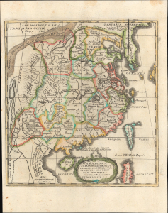
Paradigma XV Provinciarum et CLV Urbium Capitalium Sinensis Imperij Cum Templis quae Cruce X Signatur Et Domiciliis S.I.
$550.00
Acquire
- Digital Map Information
- Suitable for large format printing
- File Size: 4.59 MB
- File Type: ZIP / TIFF
- ICC color profile embedded
- Delivered instantly via download link
This is Joseph Stöcklein's c. 1729 map of China, prepared for his Der Neue Welt-bott. It was an important piece of early cultural exchange between China and Europe, which helped spur the Enlightenment. (more details)
Biblical wonders of the Sinai.
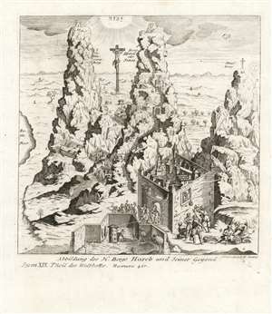
Abbildung Des H. Bergs Horeb und Seiner Gegend.
$450.00
Acquire
- Digital Map Information
- Suitable for large format printing
- Full resolution TIFF file
- ICC color profile embedded
- Delivered instantly via download link
This is a rare 1732 Joseph Stocklein depiction of Mount Horeb, (identifying it as Mount Sinai) Mount Saint Catherine, and a third mountain labeled 'Strasberg'. The stylized mountains are set in a dramatically foreshortened bird's eye view of the Holy Land, encompassing not only all of the Sinai Peninsula but also including the land of Canaan and (judging by the prominent Crucifixion) Jerusalem itself. Thus Stocklein's view places the site of Moses' receipt of the Ten Commandments in a markedly Christian framework. The view combines scenes from different stages in Biblical history: Atop Horeb/Sinai, a vignette numbered '7' shows Moses receiving the Commandments (the Ark of the Covenant lies beside him, awaiting the tablets.) Nestled between the mountains are the walled compounds of the Monastery of St. Catharina, built between 548 and 565 CE.
At the far left is a body of water, labeled as the Red Sea. At the top center, not to be mistaken for the sun (which can be seen rising to the right of the view, indicating east) is the radiance-streaming Tetragrammaton, reinforcing the identity of Mount Horeb as the 'Mountain of YHWH.' The view is numbered and lettered, with reference to an absent descriptive text. (more details)
At the far left is a body of water, labeled as the Red Sea. At the top center, not to be mistaken for the sun (which can be seen rising to the right of the view, indicating east) is the radiance-streaming Tetragrammaton, reinforcing the identity of Mount Horeb as the 'Mountain of YHWH.' The view is numbered and lettered, with reference to an absent descriptive text. (more details)