
Takei Nekketsu (sold)
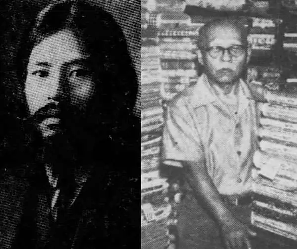
Takei Nekketsu (March 8, 1879 - April 22, 1961) (武居熱血) was a Japanese-Hawaiian merchant, photographer, editor, journalist, patent attorney, storyteller, and map maker based in Honolulu, Hawaii. Takei was born in Kudamatsu-shi, Yamaguchi-ken, Japan, the eldest son of a Sake manufacturer. Hailed as a child genius, he studied Chinese under Manumoto Sakyo at the Shoryu Temple, then at the Tokuyama Middle School. After the Sino Japanese War (1894 - 1895), Takei became fascinating with political and military events and began lecturing throughout Japan. Seeking greener pastures, he emigrated to Honolulu, Hawaii, arriving on December 15, 1903. With most Japanese in Hawaii at the time being poor uneducated cane farmers, the dashing, sophisticated, and highly educated Takei stood out, with trademark long hair, a large well-groomed mustache and beard, a black bower hat, and a frock coat. He continued lecturing among the Japanese diaspora in Hawaii, publicly asking such questions as 'Should Japan fight Russia?' and following up with 'This is the Way the Japanese Fought the Russians.' From about 1915, he owned a Kimono and dry goods shop, Takei Dry Goods, on the corner of River and Pauahi Streets, and later at 1319 Beretania St., then at 1423 S. King Street. During World War II he was briefly interred in California. Takei was well known to Hawaiian Japanese, among whom he traveled as a traditional storyteller and edgy political lecturer. While walking between plantations and Japanese-Hawaiian communities, he also produced uniquely historic documentary records of Japanese life in Hawaii through photographs and maps. These he compiled and published, often in Japan, emerging as the most prolific Hawaiian-Japanese writer of his time. When the first radio station KGU, launched Japanese programing, he signed up to tell his stories over the radio, a hobby he pursued for more than 10 years. He lived at 1414 Pickoe St., Honolulu and was a member of the Tenshō Kōtai Jingūkyō.
An exceptionally rare Japanese-Hawaiian map of Japanese friendly shops and business in 1906 Hawaii.
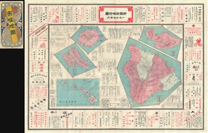
新撰布哇地圖 /一名布哇案內 / Newly Compiled Map of Hawaii.
sold
- Digital Map Information
- Suitable for large format printing
- Full resolution TIFF file
- ICC color profile embedded
- Delivered instantly via download link
An extremely rare 1906 (Meiji 39) Hawaii shopping guide printed in Hawaii by Japanese-Hawaiian Takei Nekketsu. The map details the five major islands (Hawaii, Maui, Oahu, and Kauai) separately in addition to providing a general overview of the Hawaiian Archipelago. The map proper is surrounded by advertisements for Japanese friendly business ranging from restaurants, to hatters, to hospitals, to bicycle shops.
This map is part of a genre of maps printed in the late 19th and early 20th century by Japanese immigrants. They are typically predominantly or exclusively printed in Japanese and were intended for use by local Japanese-Hawaiians or their friends and relatives visiting from Japan.
This map is accompanied by its highly attractive original binder with two maps on a globular projection. The top map illustrates east Asia and the bottom, Shows Hawaii with an apparent focus on Molokai, which is enlarged. The overall design of the map suggests friendship and cooperation between Japan and America, with numerous images of entwined Japanese and American flags. (more details)
This map is part of a genre of maps printed in the late 19th and early 20th century by Japanese immigrants. They are typically predominantly or exclusively printed in Japanese and were intended for use by local Japanese-Hawaiians or their friends and relatives visiting from Japan.
This map is accompanied by its highly attractive original binder with two maps on a globular projection. The top map illustrates east Asia and the bottom, Shows Hawaii with an apparent focus on Molokai, which is enlarged. The overall design of the map suggests friendship and cooperation between Japan and America, with numerous images of entwined Japanese and American flags. (more details)
Rare cartographic documentation of Japanese life in Hawaii - Japantown Honolulu!
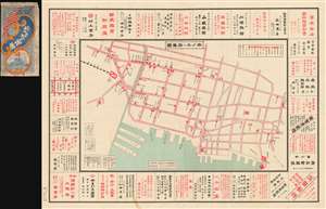
Map of Honolulu. / ホノル 府要圖
sold
- Digital Map Information
- Suitable for large format printing
- File Size: 89.92 MB
- File Type: ZIP / TIFF
- ICC color profile embedded
- Delivered instantly via download link
The only known example of this exceptional 1906 or Meiji 39 Takei Nekketsu (武居熱血) Japanese map the old Japantown of Honolulu, Hawaii. The map roughly corresponds to Honolulu's modern day Downtown and Chinatown districts, but at the time, this area was the center of Japanese life on the islands. The map identifies and advertises utilities, Japanese businesses, government offices, the Japanese consulate, banks, railroads, and more. (more details)