
Whitchurch, William (sold)

William Whitchurch (April 1748 - February 1794) was a British line engraver and printer active in London and Chichester in the second half of the 18th century. Whitchurch was born at St. Andrew Holborn. He apprenticed to the London engraver Joseph Ellis (1734 - c. 1800) from 1762. Whitchurch engraved maps for Cook, Dalrymple, Lerpinière, and others.
The first map of New South Wales Australia!
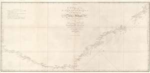
A Chart of New South Wales, or the East Coast of New-Holland. Discovered and explored by Lieutenant J. Cook, Commander of His Majesty's Bark Endeavour, in the year MDCCLXX.
sold
- Digital Map Information
- Suitable for large format printing
- DPI: 600
- File Size: 17.29 MB
- File Type: ZIP / TIFF
- ICC color profile embedded
- Delivered instantly via download link
This seminal 1773 first edition map by James Cook is the first map of New South Wales, Australia. Oriented to the West, the map extends from Cape York, Prince of Wales Island, and the Endeavour Straits to Point Hicks (Victoria). The map is a product of Cook's search for the often speculated upon southern continent or 'Terra Australis,' which scholars from the 16th century on believed, based upon ancient Greek texts, must exist at the base of the world.
After observing the Transit of Venus on June 3, 1769, Cook sailed westward, planning to return to England via the Cape of Good Hope, as he believed the Endeavour would not survive a second trip around Cape Horn. Instead he sailed west, where he hoped to discover Terra Australis. He sailed around New Zealand and headed for Tasmania, intending to follow up on Abel Tasman's work, when gales forced him northward. On April 19, 1770, his second, Zachary Hicks, signed land, what Cook immediately named Point Hicks. While Cook was most certainly aware he had not discovered 'Terra Australis', he did spend several months, from April 19 to August 22, 1770, mapping long sought east coast of New Holland (Australia), what he came to call New South Wales. He proceeded northwards, navigating the coast with great care, naming notable locations along the way.
It is of note that the coasts between Cape Flattery and Weymouth remains unmapped. This area is so full of small islands and dangerous reefs that Cook aptly named it 'The Labyrinth.' Just as he entered this area, near Cape Tribulation, the Endeavour struck a reef. On our map there is a note reading, 'On this ledge the ship laid 23 hours.' Rather than risk his ship further Cook sailed the Endeavour further out to sea, around the perilous reefs, landing at Cape York to officially name New South Wales and claim the land for England,
After observing the Transit of Venus on June 3, 1769, Cook sailed westward, planning to return to England via the Cape of Good Hope, as he believed the Endeavour would not survive a second trip around Cape Horn. Instead he sailed west, where he hoped to discover Terra Australis. He sailed around New Zealand and headed for Tasmania, intending to follow up on Abel Tasman's work, when gales forced him northward. On April 19, 1770, his second, Zachary Hicks, signed land, what Cook immediately named Point Hicks. While Cook was most certainly aware he had not discovered 'Terra Australis', he did spend several months, from April 19 to August 22, 1770, mapping long sought east coast of New Holland (Australia), what he came to call New South Wales. He proceeded northwards, navigating the coast with great care, naming notable locations along the way.
It is of note that the coasts between Cape Flattery and Weymouth remains unmapped. This area is so full of small islands and dangerous reefs that Cook aptly named it 'The Labyrinth.' Just as he entered this area, near Cape Tribulation, the Endeavour struck a reef. On our map there is a note reading, 'On this ledge the ship laid 23 hours.' Rather than risk his ship further Cook sailed the Endeavour further out to sea, around the perilous reefs, landing at Cape York to officially name New South Wales and claim the land for England,
I now once more hoisted English Coulers and in the Name of His Majesty King George the Third took possession of the whole Eastern Coast from the above Latitude [38] down to this place by the name of New South Wales, together with all the Bays, Harbors, Rivers, and Island s situate upon the said coast. (Cook, J., Journal, August 22, 1770)Until this time it was assumed that Australia, or New Holland as it was known, was a barren wasteland, as the Dutch navigators had explored only a small part of the arid western coast. Cook on the other hand, sailed up the fertile east coast, and was impressed by what he saw. It was Cook who recommended settlement and persuaded Joseph Banks to argue for using the remote continent as a penal colony. This map is significant for Australia collectors as the first definitive mapping of the coasts of New South Wales. Cook's nomenclature largely remains in use today. The map notes both Botany Bay and Port Jackson. (more details)
The first official map of Cook's first voyage - the best map of the Australia, the South Pacific, and New Zealand of it time.
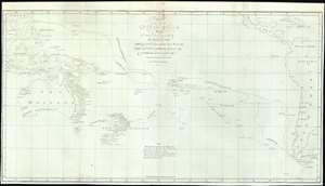
Chart of part of the South Sea, Shewing the Tracts and Discoveries made by His Majesty's Ships Dolphin, Commodore Byron, and Tamer, Captn. Mouat, 1765. Dolphin, Captn., Wallis, and Swallow, Captn. Carteret, 1767. And Endeavour, Lieutenant Cooke, 1769.
sold
- Digital Map Information
- Suitable for large format printing
- File Size: 18.3 MB
- File Type: ZIP / TIFF
- ICC color profile embedded
- Delivered instantly via download link
This is a rare 1773 map of the South Pacific issued to illustrates English voyages of exploration in this region between 1765 and 1769, including the voyages of John Byron (1723 - 1786), Samuel Wallis (1728 - 1795), Philip Carteret (1733 - 1796), and James Cook (1728 - 1779). At the time of publication this was the most accurate extant map of this region, unveiling a wealth of new information to curious Europeans. Coverage extends from Sumatra to South America, and from Baja California and Taiwan to Tierra del Fuego, including all of Australia, Polynesia, New Zealand, the Philippines, Melanesia, and eastern Indonesia. Tasmania or Van Diemen's Land is notably attached to the Australian mainland. Tracks drawn from ship's original logs detail with precision the routes taken by Commodore Byron and Captain Mouat (1765), Captain Carteret (1767), Captain Wallis (1767), and Lieutenant James Cook (1769). (more details)
The quest for Terre Australis.
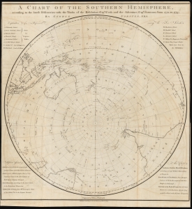
A Chart of the Southern Hemisphere according to the latest Discoveries with the Tracks of the Resolution, Cap.n Cook; and the Adventure, Cap.n Furneaux; from 1772, to 1775.
sold
- Digital Map Information
- Suitable for large format printing
- DPI: 600
- File Size: 68.68 MB
- File Type: ZIP / TIFF
- ICC color profile embedded
- Delivered instantly via download link
A rare 1777 George Forster map of James Cook's second voyage of exploration to the South Pole, from 1772 to 1775. (more details)