
Yukosha (sold) (株式會社有恆社)

Yukosha (株式會社有恆社; 1872 - 1943) was a Japanese paper manufacturing company and occasional publisher that existed in the Meiji and Taisho eras. In 1874, it was a pioneer in the Japanese paper industry, being the first company in Japan to produce Western-style paper, using an imported paper machine. Established in 1872 by the Asano family, the former lords of the Hiroshima domain, it was gradually absorbed by the Oji Paper Co. (王子製紙株式會社) between 1918 and 1924. Oji continued to operate Yukosha's mills until they were switched over to producing munitions during World War II and converted to other purposes after the war.
AKA: 株式會社有恆社
'Kawaii' military expansionism.
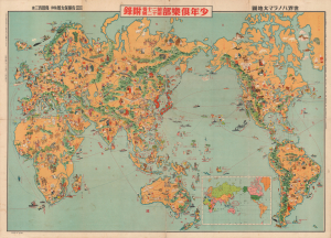
世界パノラマ大地圖 / World Panorama Map.
sold
- Digital Map Information
- Suitable for large format printing
- File Size: 194.97 MB
- File Type: ZIP / TIFF
- ICC color profile embedded
- Delivered instantly via download link
A remarkable 1933 Japanese issue pictorial map of the world drawn by Keizo Shimada (島田啓三). The map's cartoonish (manga) content seems deceptively innocent when this map is, ultimately, a propaganda piece underscoring nationalistic Japanese militarism in the lead up to the Second Sino-Japanese War (1937 - 1945) and World War II (1939 - 1945). (more details)
A uniquely Japanese combination of 'Kawaii' and military expansionism.
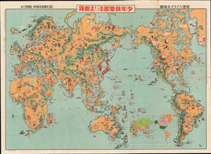
世界パノラマ大地圖 / World Panorama Map.
sold
- Digital Map Information
- Suitable for large format printing
- File Size: 58.72 MB
- File Type: ZIP / TIFF
- ICC color profile embedded
- Delivered instantly via download link
A remarkable 1933 Japanese issue pictorial map of the world drawn by Keizo Shimada (島田啓三). Centered on the Japanese Empire, which is highlighted in red and includes both Taiwan and Korea, this map extends to cover the entire world except for the Atlantic, which is only minimally addressed. (more details)
War Propaganda for kids.
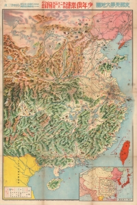
支那見學大地圖 / Large Study Map of China.
sold
- Digital Map Information
- Suitable for large format printing
- File Size: 82.41 MB
- File Type: ZIP / TIFF
- ICC color profile embedded
- Delivered instantly via download link
This is a rare 1938 (Showa 13) World War II or Second Sino-Japanese War manga-style propaganda map of China by a team of artists, printers, and editors led by Satō Yūtarō (佐藤裕太郎). Published for the magazine Youth Club (or Shōnen Club, 小年俱樂部), this map was meant to educate Japanese children about China and justify Japan's war there. (more details)
Japanese Military Hardware on the Eve of the Pacific War.
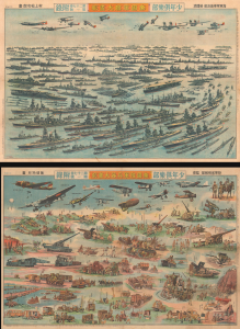
帝國軍艦大畫報 / 帝國陸軍兵器大畫報 / [Imperial Warship Pictorial / Imperial Army Weapons Pictorial].
sold
- Digital Map Information
- Suitable for large format printing
- Full resolution TIFF file
- ICC color profile embedded
- Delivered instantly via download link
This is a striking 1940 Shōnen Club double-sided sheet depicting Japanese military hardware during the Second-Sino Japanese War (1937 - 1945) and on the eve of the Pacific War (1941 - 1945), part of World War II. It reflects the degree to which militarism had become quotidian in Japan, on a total mobilization footing since 1938 due to its full-scale war in China. More subtly, it also represents the deep rivalry between the Imperial Japanese Navy (IJN) and Imperial Japanese Army (IJA) that hamstrung Japan's war effort. (more details)