
Iconic 18th century map of Ireland.
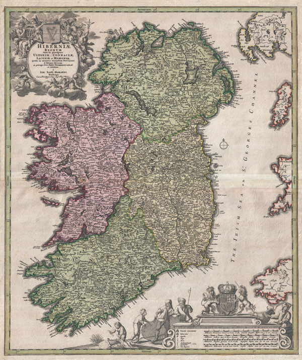
Hiberniae Regnum tam in Praecipuas Ultoniae, Connaciae, Laceniae et Momoniae quam in Minores Earundem Provincias
sold
- Digital Map Information
- Suitable for large format printing
- DPI: 300
- File Size: 20.41 MB
- File Type: ZIP / TIFF
- ICC color profile embedded
- Delivered instantly via download link
An iconic c. 1716 map of Ireland by Johann Baptist Homann. A fine example of Homann's work, this map bears all of the distinctive hallmarks of Homann's style at the height of his career: a strong dark impression, heavy yet detailed engraving work, elaborate ... (more details)
Early pictorial map of London, England.

Geographia Pictoria Plan of London.
sold
- Digital Map Information
- Suitable for large format printing
- File Size: 28.37 MB
- File Type: ZIP / TIFF
- ICC color profile embedded
- Delivered instantly via download link
This is a wonderful map of pocket map of London and published c. 1924 by Geographia Ltd. Covers downtown London from the Hammersmith Bridge and Wormwood scrubs eastward past Hyde Park and Buckingham Place to Whitechapel Road and the London Docks. Unlike ... (more details)
Map of France's Selles-sur-Cher cheese region.

Dept. de Loir-et-Cher
sold
- Digital Map Information
- Suitable for large format printing
- DPI: 300
- File Size: 10.03 MB
- File Type: ZIP / TIFF
- ICC color profile embedded
- Delivered instantly via download link
This is a fascinating 1852 map of the French department Loir-et-Cher, France. This area is mainly known for its production of Selles-sur-Cher, a fine goats-milk cheese. The whole is surrounded by elaborate decorative engravings designed to illustrate ... (more details)
Map of France's Armagnac region.

Dept. des Landes
sold
- Digital Map Information
- Suitable for large format printing
- DPI: 300
- File Size: 8.97 MB
- File Type: ZIP / TIFF
- ICC color profile embedded
- Delivered instantly via download link
This is a fascinating 1852 map of the French department Landes, France. This area is known for its production of Chalossais, a white cow cheese with a gentle, acidic edge. Tursan wine is also distilled here, along with Armagnac brandy. The whole is ... (more details)

Dept. du Jura
sold
- Digital Map Information
- Suitable for large format printing
- DPI: 300
- File Size: 9.63 MB
- File Type: ZIP / TIFF
- ICC color profile embedded
- Delivered instantly via download link
This is a fascinating 1852 map of the French department Jura, France. The Jura wines are very distinctive and unusual, such as Vin Jaune, which is made by a similar process to sherry, developing under a flor of yeast. This is made from the local ... (more details)

Dept. de l'Isere.
sold
- Digital Map Information
- Suitable for large format printing
- DPI: 300
- File Size: 8.46 MB
- File Type: ZIP / TIFF
- ICC color profile embedded
- Delivered instantly via download link
This is a fascinating 1852 map of the French department Isere, France. This area is known for its production of Bleu du Vercors-Sassenage, a mild cow's milk blue cheese, and Saint-Marcellin, a softer cheese. The whole is surrounded by elaborate ... (more details)
Map of France's Chenin wine region.

Dept. d'Indre et Loire.
sold
- Digital Map Information
- Suitable for large format printing
- DPI: 300
- File Size: 8.17 MB
- File Type: ZIP / TIFF
- ICC color profile embedded
- Delivered instantly via download link
This is a fascinating 1852 map of the French department of Indre Et Loire. France. This area is known for its production of Chenin blanc, a white wine grape with a high acidity, and wide variety of goat cheeses. The whole is surrounded by ... (more details)
Map of France's Chinon wine region.

Dept. de l'Indre.
sold
- Digital Map Information
- Suitable for large format printing
- DPI: 300
- File Size: 9.1 MB
- File Type: ZIP / TIFF
- ICC color profile embedded
- Delivered instantly via download link
This is a fascinating 1852 map of the French department of Indre, France. Part of the Loire Valley wine region, this area is known for its production of Chinon wines, typically red, and production of Pouligny-Saint-Pierre, goats'-milk ... (more details)
Map of France's Languedoc wine region.

Dept. de l'Herault.
sold
- Digital Map Information
- Suitable for large format printing
- DPI: 300
- File Size: 9.04 MB
- File Type: ZIP / TIFF
- ICC color profile embedded
- Delivered instantly via download link
This is a fascinating 1852 map of the French department of Herault, France. This area is home to a wide variety of vineyards and is part of the larger Languedoc wine-growing region, the oldest in France. The red wines produced here ... (more details)
Map of France's Armagnac brandy region.

Dept. de Gers.
sold
- Digital Map Information
- Suitable for large format printing
- DPI: 300
- File Size: 9.88 MB
- File Type: ZIP / TIFF
- ICC color profile embedded
- Delivered instantly via download link
This is a fascinating 1852 map of the French department of Gers, France. This area of is known especially for its production of Armagnac Brandy and Floc de Gascogne, a sweet wine. It is also home to Côtes de Gascogne, a ... (more details)
Map of France's Buzet wine region.

Dept. de la Hautes-Garonne.
sold
- Digital Map Information
- Suitable for large format printing
- DPI: 300
- File Size: 9.56 MB
- File Type: ZIP / TIFF
- ICC color profile embedded
- Delivered instantly via download link
This is a fascinating 1852 map of the French department of Haute-Garonne, France. This area of France produces the delicious but lesser known Buzet wines, and tender Rocamadour cheeses. The whole is surrounded by ... (more details)
Map of region surrounding Chartres Cathedral, France.

Dept. d'Eure et Loir.
sold
- Digital Map Information
- Suitable for large format printing
- DPI: 300
- File Size: 8.99 MB
- File Type: ZIP / TIFF
- ICC color profile embedded
- Delivered instantly via download link
This is a fascinating 1852 map of the French department of Eure Et Loir, France. This area is home to the famous Chartres Cathedral. The whole is surrounded by elaborate decorative engravings designed to ... (more details)

Dept. de l'Eure.
sold
- Digital Map Information
- Suitable for large format printing
- DPI: 300
- File Size: 10.22 MB
- File Type: ZIP / TIFF
- ICC color profile embedded
- Delivered instantly via download link
This is a fascinating 1852 map of the French department of Eure, France. This region of France is home to Giverny, where impressionist Claude Monet's home and garden can be seen. The whole is surrounded ... (more details)
Map of France's Picodon cheese region.

Dept. de la Drome.
sold
- Digital Map Information
- Suitable for large format printing
- DPI: 300
- File Size: 8.74 MB
- File Type: ZIP / TIFF
- ICC color profile embedded
- Delivered instantly via download link
This is a fascinating 1852 map of the French department of Drome, France. This area is known for its production of Picodon, a spicy goats-milk cheese. The whole is surrounded by elaborate decorative ... (more details)

Dept. du Doubs.
sold
- Digital Map Information
- Suitable for large format printing
- DPI: 300
- File Size: 9.73 MB
- File Type: ZIP / TIFF
- ICC color profile embedded
- Delivered instantly via download link
This is a fascinating 1852 map of the French department of Doubs, France. The whole is surrounded by elaborate decorative engravings designed to illustrate both the natural beauty and trade richness ... (more details)
Map of France's Monbazillac wine region and Cabécou cheese region.

Dept. de la Dordogne.
sold
- Digital Map Information
- Suitable for large format printing
- DPI: 300
- File Size: 9.58 MB
- File Type: ZIP / TIFF
- ICC color profile embedded
- Delivered instantly via download link
This is a fascinating 1852 map of the French department of Dordogne, France. This area is best known for its production of Monbazillac, a sweet white wine, and Cabécou, a soft goat cheese. The ... (more details)

Dept. e Seine et Oise.
sold
- Digital Map Information
- Suitable for large format printing
- DPI: 300
- File Size: 9.38 MB
- File Type: ZIP / TIFF
- ICC color profile embedded
- Delivered instantly via download link
This is a fascinating 1852 map of the French department of Seine-et-Oise. Centered on Versailles, its administrative center, Seine-et-Oise extends from Espernon to Melun and from Pontoise to ... (more details)
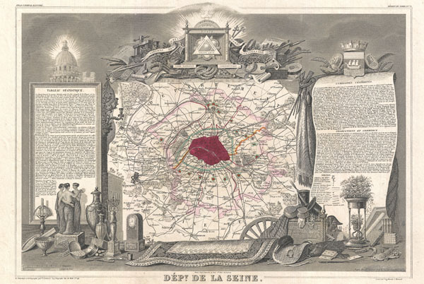
Dept. de la Seine.
sold
- Digital Map Information
- Suitable for large format printing
- DPI: 300
- File Size: 10.38 MB
- File Type: ZIP / TIFF
- ICC color profile embedded
- Delivered instantly via download link
This is a fascinating 1852 map of the French department of Seine. Focusing on Paris, this map covers from the Foret de St. Germain to the Bois Notre Dame and from Versailles to Chelles. ... (more details)
Levassuer's stunning map of the Bordeaux wine region.

Dept. de la Gironde.
sold
- Digital Map Information
- Suitable for large format printing
- DPI: 300
- File Size: 9.71 MB
- File Type: ZIP / TIFF
- ICC color profile embedded
- Delivered instantly via download link
This is a fascinating 1852 map of the French department of Gironde. This coastal department is the seat of the Bordeaux wine region and produces many of the world's finest reds. Shows ... (more details)

Oceanie.
sold
- Digital Map Information
- Suitable for large format printing
- Full resolution TIFF file
- ICC color profile embedded
- Delivered instantly via download link
A fine example of V. Levasseur's desirable decorative map of Polynesia and Australia, dated 1852. Covers the Pacific from Sumatra to the California Coast, focusing on Australia, New ... (more details)