
Sudo's application for permission to travel to China.

[Sudo Collection Passport]
sold
- Digital Map Information
- Suitable for large format printing
- File Size: 34.97 MB
- File Type: ZIP / TIFF
- ICC color profile embedded
- Delivered instantly via download link
Part of Sudo Collection. Not sold Separately: Click here for full collection. Manuscript Booklet: Overseas Navigation Permit Application for travel to Shanghai for one, Sudo, Tochigi Prefecture, ... (more details)
Covers to the Sudo Taiwan collection.

[Sudo Collection Covers]
sold
- Digital Map Information
- Suitable for large format printing
- File Size: 36.06 MB
- File Type: ZIP / TIFF
- ICC color profile embedded
- Delivered instantly via download link
Part of Sudo Collection. Not sold Separately: Click here for full collection. Original Covers of the Collection with text by Sudo's brother, describing Sudo's compilation of the maps and his ... (more details)
Manuscrip map of Xiamen based on Admiralty surveys.
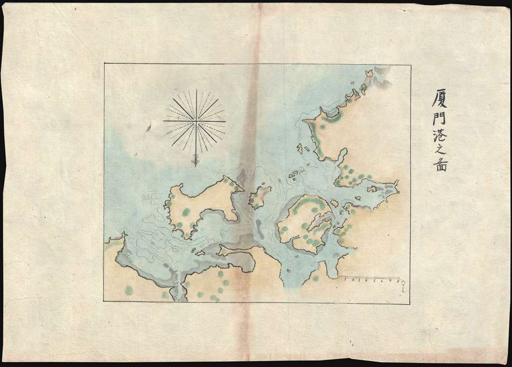
厦門港之圖 / Map of Xiamen Port.
sold
- Digital Map Information
- Suitable for large format printing
- File Size: 12.41 MB
- File Type: ZIP / TIFF
- ICC color profile embedded
- Delivered instantly via download link
Part of Sudo Collection. Not sold Separately: Click here for full collection. A striking 1874 manuscript map of Amoy or Xiamen harbor (厦门市), Fujian, China. The map is oriented to the ... (more details)
Manuscript map of Fuzhou, Fujian, China

福刕港口南台廹圖 / Fuzhou Port South Station.
sold
- Digital Map Information
- Suitable for large format printing
- Full resolution TIFF file
- ICC color profile embedded
- Delivered instantly via download link
Part of Sudo Collection. Not sold Separately: Click here for full collection. A striking 1874 manuscript map of Fuzhou harbor (福州市), China. The map focuses on the entrance to the ... (more details)
General Map of Tamsui River Entrance, Taiwan.
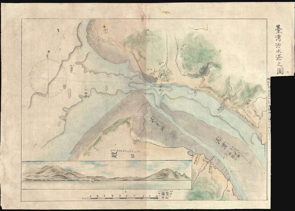
台湾淡水港之图 / Map of Tamusi Harbor.
sold
- Digital Map Information
- Suitable for large format printing
- Full resolution TIFF file
- ICC color profile embedded
- Delivered instantly via download link
Part of Sudo Collection. Not sold Separately: Click here for full collection. A striking general map detailing the entrance to the Tamsui River and Tamsui Harbor, near modern day ... (more details)
Detailed Map of Tamsui Harbor and River Entrance, Taiwan.

台湾淡水港之图 / Map of Tamusi Harbor.
sold
- Digital Map Information
- Suitable for large format printing
- Full resolution TIFF file
- ICC color profile embedded
- Delivered instantly via download link
Part of Sudo Collection. Not sold Separately: Click here for full collection. An interesting map detailing the entrance to the Tamsui River and Tamsui Harbor, near modern day ... (more details)
The most enigmatic map of the Sudo series illustrating the aboriginal tribes of Southern Taiwan.

[Map of the Southern Part of Taiwan]
sold
- Digital Map Information
- Suitable for large format printing
- File Size: 18.35 MB
- File Type: ZIP / TIFF
- ICC color profile embedded
- Delivered instantly via download link
Part of Sudo Collection. Not sold Separately: Click here for full collection. This is by far the most enigmatic and elusive of the Sudo 1874 series. The map is laid down on ... (more details)
Sudo manuscript map of south Formosa based upon Legendre. Part of a set.

台灣南部之圖 / Map of the Southern Part of Taiwan.
sold
- Digital Map Information
- Suitable for large format printing
- File Size: 16.98 MB
- File Type: ZIP / TIFF
- ICC color profile embedded
- Delivered instantly via download link
Part of Sudo Collection. Not sold Separately: Click here for full collection. The largest of the two south Taiwan detail manuscript maps from the 1874 Sudo series. Like ... (more details)
Japanese mansucript version of the 19th century Admiraltly chart of Taiwan. Part of a set.

[Formosa]
sold
- Digital Map Information
- Suitable for large format printing
- Full resolution TIFF file
- ICC color profile embedded
- Delivered instantly via download link
Part of Sudo Collection. Not sold Separately: Click here for full collection. The third and smallest of the general maps of Taiwan in the Sudo collection. This map is ... (more details)
Japanese mansucript version of the 1870 Le Gendre map of Taiwan. Part of a set.
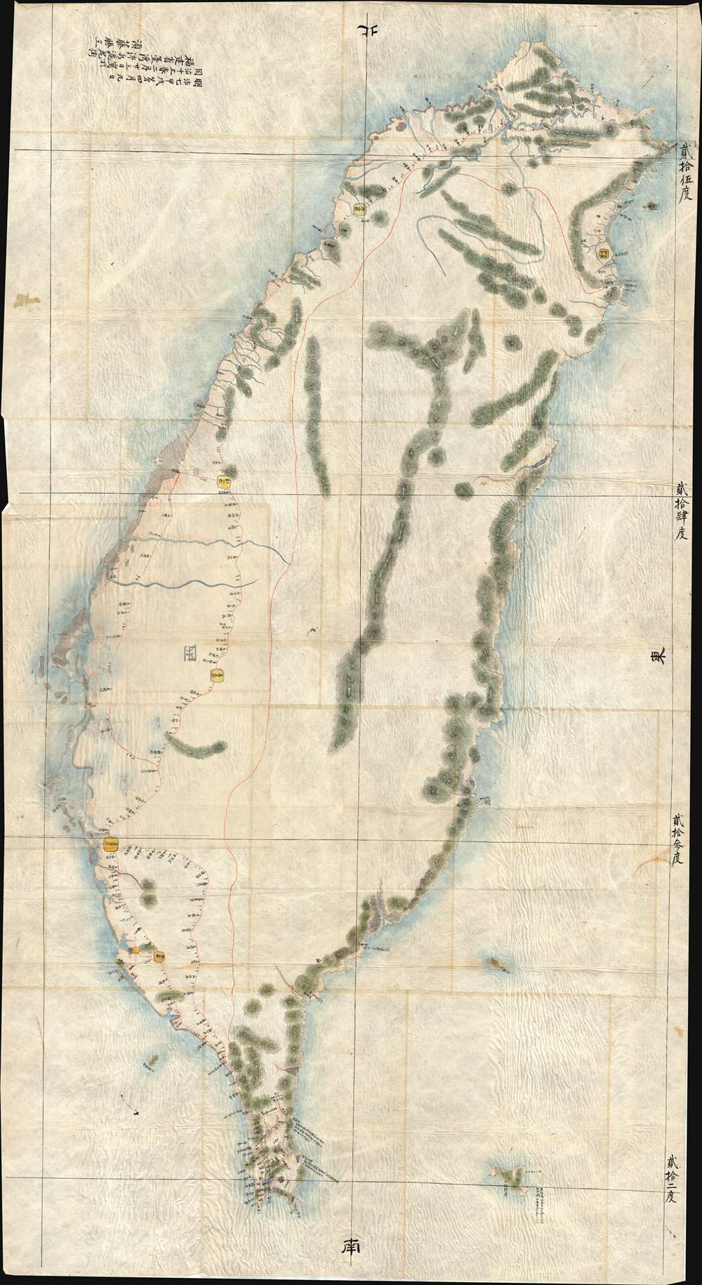
[Formosa]
sold
- Digital Map Information
- Suitable for large format printing
- File Size: 171.72 MB
- File Type: ZIP / TIFF
- ICC color profile embedded
- Delivered instantly via download link
Part of Sudo Collection. Not sold Separately: Click here for full collection. By far the largest map in the Sudo collection. It is based almost entirely on the ... (more details)
A large and incredibly rare French celestial chart - one of the first to depict the stars in a more scientific manner.
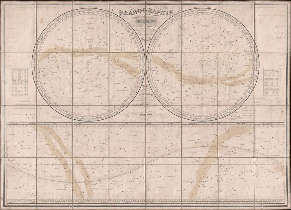
Uranographie.
sold
- Digital Map Information
- Suitable for large format printing
- DPI: 300
- File Size: 34.55 MB
- File Type: ZIP / TIFF
- ICC color profile embedded
- Delivered instantly via download link
This is an 1831 Charles Dien celestial chart or uranography of the stars in two hemispheres. Uranography is the branch of astronomy concerned with the description ... (more details)
An important map of Asia illustrating several aspects of classic speculative European cartography of Asia.
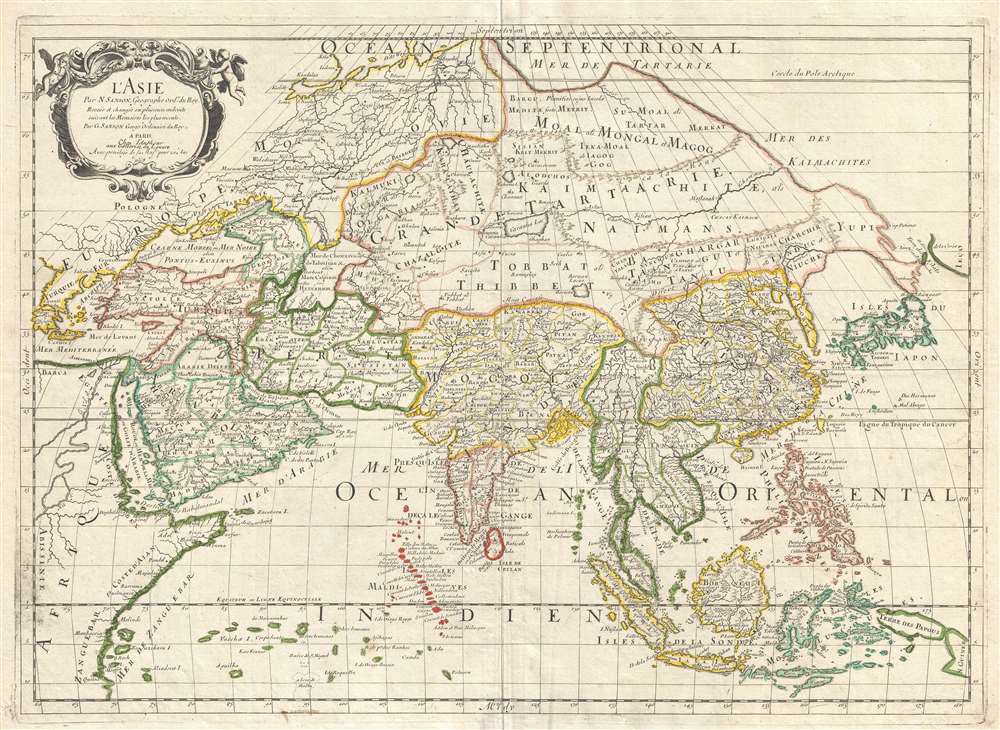
L'Asie.
sold
- Digital Map Information
- Suitable for large format printing
- DPI: 300
- File Size: 10.41 MB
- File Type: ZIP / TIFF
- ICC color profile embedded
- Delivered instantly via download link
This is a 1669 Nicolas and Guillaume Sanson map of Asia. Overall an unusual projection and centered on Tibet, the map depicts the entire continent of Asia from Greece to the Kurile Islands and from the Arctic Ocean to New Guinea, including parts of Europe and Africa. This represents the second edition of the Sanson map of Asia, with one notable difference being the depiction of Korea as an elongated peninsula, whereas in the first edition Korea was shown as an island. Other aspects of East Asian geography, however, remain fairly speculative. Hokkaido is illustrated as being attached to the mainland as part of a vast peninsula called Yupi (Sakhalin). Separated from the landmass by the narrow Strait of St. Vries is a mysterious landmass labeled as Ieco, a name which itself is commonly associated with Hokkaido. Here, Sanson has moved the toponymy further east and attached it to an oversized mapping of the Kuril Islands. It is also important to note the incomplete depiction of New Guinea. (more details)
Stunning early view of Cairo expressing European fascination with oriental cultures.
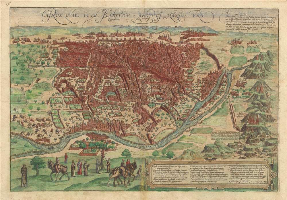
Cairus, quae olim Babylon; Aegypti Maxima Urbs.
sold
- Digital Map Information
- Suitable for large format printing
- DPI: 300
- File Size: 9.81 MB
- File Type: ZIP / TIFF
- ICC color profile embedded
- Delivered instantly via download link
This is a striking c. 1572 view map of Cairo, Egypt during the Ottoman Period issued by Braun and Hogenberg. The map presents Cairo from the right bank of the Nile, so looking towards the southeast with the Pyramids of Giza and the Great Sphinx appearing at right. Braun and Hogenberg's Cairo is a city of uniform rectilinearity interspaced with fortresses, gated gardens, and soaring minarets. The Great Pyramids of Giza, appearing at right, are highly stylized, presented on green hills, and clearly indicate that artist had never actually seen them. (more details)
Nova Et Vera Exhibitio Geographica Insularum Marianarum Cum Insulis De Pais Marianis ad Austrum Obiectis Nuperrime Inventis.

Nova Et Vera Exhibitio Geographica Insularum Marianarum Cum Insulis De Pais Marianis ad Austrum Obiectis Nuperrime Inventis.
sold
- Digital Map Information
- Suitable for large format printing
- DPI: 300
- File Size: 4.52 MB
- File Type: ZIP / TIFF
- ICC color profile embedded
- Delivered instantly via download link
A stunning 1703 map of the Philippines, South China Sea, western Pacific, and Guam by Heinrich Scherer. Essentially two maps on a single sheet, the primary map, appearing at right, covers from Korea to New Guinea and from Borneo to the Marinara Islands, including China, southern Japan, the Philippines, the Marinara Islands, and parts of Indonesia and New Guinea. The left had map is a detailed study of Guam - which has recently converted to Christianity. It bears a Jesuit themed title cartouche and exhibits several ships (Magellan?) and various sea creatures in the Pacific. (more details)
Promotes tourism by rail in British Columbia - including a visit to Jasper National Park, then the largest national park in the Americas.

The Triangle Tour of British Columbia. / Alaska and the Yukon.
sold
- Digital Map Information
- Suitable for large format printing
- File Size: 29.87 MB
- File Type: ZIP / TIFF
- ICC color profile embedded
- Delivered instantly via download link
This is a c. 1927 Canadian National Railway map of the Triangle Tour of British Columbia. The map depicts two train and one steamship route, allowing the tourist ... (more details)
Two Japanese maps tracing the Battle of Singapore during World War II and printed shortly after the Japanese defeated the British.

[Defense of Singapore].
sold
- Digital Map Information
- Suitable for large format printing
- File Size: 9.12 MB
- File Type: ZIP / TIFF
- ICC color profile embedded
- Delivered instantly via download link
This is a rare set of two 1942 or Showa 17 Japanese maps of Singapore tracing the events of the Battle of Singapore. Each map depicts Singapore Island in its ... (more details)
A set of five Japanese maps tracing the naval situation in the Pacific during World War II.

[Naval War Map]. / 圖概要過經戰作軍海.
sold
- Digital Map Information
- Suitable for large format printing
- Full resolution TIFF file
- ICC color profile embedded
- Delivered instantly via download link
This is a rare set of 5 Japanese maps of the Pacific War, also known as the Pacific Theater of Operations, during World War II. Each map depicts a wide area ... (more details)
First edition of rare geographical themed game.

Pirate and Traveler.
sold
- Digital Map Information
- Suitable for large format printing
- File Size: 1.52 MB
- File Type: ZIP / TIFF
- ICC color profile embedded
- Delivered instantly via download link
An amusing 1911 geographical board game, Pirate and Traveler , by Milton Bradley. Game play involves drawing a travel card which dictates the journeys that ... (more details)
An ardently pro-McKinley and pro-expansionism political cartoon from just after the Spanish-American War.
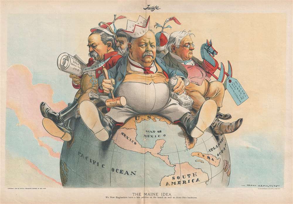
The Maine Idea.
sold
- Digital Map Information
- Suitable for large format printing
- File Size: 5.54 MB
- File Type: ZIP / TIFF
- ICC color profile embedded
- Delivered instantly via download link
This is an 1899 Grant Hamilton political cartoon lambasting four New England Republican Congressmen for their opposition to the Spanish-American War, portraying each as a child sitting on top of the world. Three of the Congressmen hailed from the state of Maine: Representative Thomas Reed, Representative Charles Boutelle, and Senator William Frye. Senator George Hoar was from Massachusetts. (more details)
A political cartoon celebrating America's expansion across the globe, both in territory and through influence.

A Thing Well Begun is Half Done.
sold
- Digital Map Information
- Suitable for large format printing
- File Size: 9.3 MB
- File Type: ZIP / TIFF
- ICC color profile embedded
- Delivered instantly via download link
This is an 1899 Victor Gillam political cartoon heralding the inauguration of construction of the Nicaragua Canal. Illustrating most of the Western ... (more details)