
Mitchell's representation of the state of Indiana.
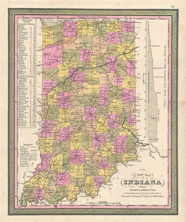
A New Map of Indiana with its Roads & Distances.
sold
- Digital Map Information
- Suitable for large format printing
- DPI: 300
- File Size: 7 MB
- File Type: ZIP / TIFF
- ICC color profile embedded
- Delivered instantly via download link
This is a lovely 1849 Mitchell map of Indiana by Samuel Augustus Mitchell. Presents a profile of the Wabash and Erie Canal along the right border. Indiana's many canals and railroad lines are highlighted in blue and orange, respectively. Steam Boat Routes with ... (more details)
Michigan during a period of rapid development.

A New Map of Michigan with its Canals, Roads & Distances.
sold
- Digital Map Information
- Suitable for large format printing
- DPI: 300
- File Size: 7.06 MB
- File Type: ZIP / TIFF
- ICC color profile embedded
- Delivered instantly via download link
This is a beautiful 1849 map of Michigan by Samuel Augustus Mitchell. The whole is engraved and colored in Mitchell's distinctive style with green border work and vivid pastels. Political and topographical features are noted and color coded with elevation ... (more details)
19th century mapof Ohio with a profile of the Ohio Canal.

A New Map of Ohio with its Canals, Roads & Distances.
sold
- Digital Map Information
- Suitable for large format printing
- DPI: 300
- File Size: 6.98 MB
- File Type: ZIP / TIFF
- ICC color profile embedded
- Delivered instantly via download link
This is a lovely 1849 map of the state of Ohio by S. A. Mitchell. It covers the entire state in beautiful detail with a profile of the Ohio Canal along the lower border. On the map proper, Ohio's many canal routes are highlighted in blue while the state's ... (more details)
Map of Tennessee featuring Knoxville and Nashville.

A New Map of Tennessee with its Canals, Roads & Distances from Place to Place along the Stage & Steam Boat Routes.
sold
- Digital Map Information
- Suitable for large format printing
- DPI: 300
- File Size: 7.02 MB
- File Type: ZIP / TIFF
- ICC color profile embedded
- Delivered instantly via download link
This is a lovely map of Tennessee by Samuel Augustus Mitchell dating to 1849. The map covers the entire state in beautiful detail and includes two insets. The inset in the top left features the Environs of Nashville, while the second inset in the top ... (more details)
Large inset of New Orleans.

A New Map of Louisiana with its Canals, Roads and Distances from place to place, along the Stage and Steam Boat Routes.
sold
- Digital Map Information
- Suitable for large format printing
- DPI: 300
- File Size: 7.07 MB
- File Type: ZIP / TIFF
- ICC color profile embedded
- Delivered instantly via download link
This is an attractive 1849 example of Mitchell’s map of Louisiana. It depicts the entire state color coded according to individual counties. Shows canals and roads with notations regarding steamboat and overland mileage. A large inset in the upper ... (more details)
Scarce working nautical chart of Nantucket.

No. 11 From Monomoy and Nantucket Shoas to Muskeget Channel Mass.
sold
- Digital Map Information
- Suitable for large format printing
- File Size: 25.58 MB
- File Type: ZIP / TIFF
- ICC color profile embedded
- Delivered instantly via download link
An uncommon 1883 U.S. Coast and Geodetic Survey nautical chart or maritime map of Nantucket, Massachusetts. The map covers from Hyannis to Chatham Port and south to include most of Nantucket island to Old Man's Shoal. Only the western most part of ... (more details)
Scarce working nautical chart of Naragannsett Bay.

Cuttyhyunk to Block Island including Naragansett Bay.
sold
- Digital Map Information
- Suitable for large format printing
- File Size: 21.89 MB
- File Type: ZIP / TIFF
- ICC color profile embedded
- Delivered instantly via download link
An uncommon 1915 U.S. Coast and Geodetic Survey nautical chart or maritime map of Narragansett Bay, Rhode Island. The chart covers from Cuttyhunk to Block Island, including all of Narragansett Bay. The map is primarily coastal, but offers ... (more details)
Scarce map of Mount Desert Island by Maine's most notable maker of pictorial maps.
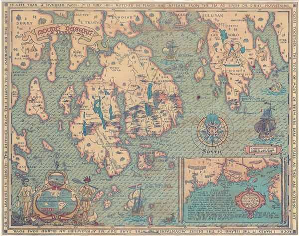
A Map of Mount Desert Island.
sold
This high decorative 1832 pictorial map of Mount Desert Island, and vicinity, was drawn and published by Luther S. Phillips. The map covers the main coast from Surry to Dyer Neck, including Mount Desert Island, Long Island, Bartlett ... (more details)
Highly decorative map of Rome.

Roma.
sold
- Digital Map Information
- Suitable for large format printing
- File Size: 17.7 MB
- File Type: ZIP / TIFF
- ICC color profile embedded
- Delivered instantly via download link
A highly decorative 1920 map of Rome by Augusto Trabacchi. This map is a combination of a traditional street plan and a topographical map. For the developed urban center of Rome, streets are named and blocks are shaded orange. ... (more details)
Mitchell's depiction of the state of Mississippi.

A New Map of Mississippi with its Roads and Distances.
sold
- Digital Map Information
- Suitable for large format printing
- DPI: 300
- File Size: 5.86 MB
- File Type: ZIP / TIFF
- ICC color profile embedded
- Delivered instantly via download link
A fine example of S. A. Mitchell's 1849 map of Mississippi. Steam bout routes along with distances are presented in tabular format in the lower left quadrant. Political and topographical features are noted and color coded with ... (more details)
Mitchell's early map of Alabama.

A New Map of Alabama with its Roads and Distances from place to place, along the Stage and Steam Boat Routes.
sold
- Digital Map Information
- Suitable for large format printing
- DPI: 300
- File Size: 7.17 MB
- File Type: ZIP / TIFF
- ICC color profile embedded
- Delivered instantly via download link
This is a lovely 1849 map of Alabama by Samuel Augustus Mitchell. Steamboat routes and mileages are presented in tabular format in the lower left quadrant. Political and topographical features are noted and color coded with ... (more details)
The state of Georgia with its roads.

A New Map of Georgia with its Roads and Distances.
sold
- Digital Map Information
- Suitable for large format printing
- DPI: 300
- File Size: 6.25 MB
- File Type: ZIP / TIFF
- ICC color profile embedded
- Delivered instantly via download link
This is a fine example of S. A. Mitchell's 1849 map of Georgia. Through its elegant design, this map of Georgia centers our attention on the roads and railroads that crisscross the state. Steamboat routes and mileages are ... (more details)
Pre Civil War map of South Carolina.

A New Map of South Carolina with its Canals, Roads and Distances from place to place, along the Stage and Steam Boat Routes.
sold
- Digital Map Information
- Suitable for large format printing
- DPI: 300
- File Size: 6.7 MB
- File Type: ZIP / TIFF
- ICC color profile embedded
- Delivered instantly via download link
This is a beautiful example of Samuel Augustus Mitchell's important 1849 map of South Carolina. This map shows cities, topographical features, railways, ferries and roads with color coding at the county level. In addition ... (more details)
Shows the site of the nation's first Gold Rush.

A New Map of Nth. Carolina with its Canals, Roads and Distances from place to place, along the Stage and Steam Boat Routes.
sold
- Digital Map Information
- Suitable for large format printing
- DPI: 300
- File Size: 6.61 MB
- File Type: ZIP / TIFF
- ICC color profile embedded
- Delivered instantly via download link
This is an important 1849 map of North Carolina by Samuel Augustus Mitchell. This map shows cities, topographical features, railways, ferries and roads with color coding at the county level. In addition to cartographic ... (more details)
Map of Virginia predating its separating into West Virginia and Virginia.

A New Map of Virginia with its Canals, Roads and Distances from place to place, along the Stage and Steam Boat Routes.
sold
- Digital Map Information
- Suitable for large format printing
- DPI: 300
- File Size: 7.56 MB
- File Type: ZIP / TIFF
- ICC color profile embedded
- Delivered instantly via download link
This is a lovely 1849 map of Virginia, including West Virginia, by the legendary American map publisher Samuel Augustus Mitchell. This hand colored lithographic map predates the 1862 separation of Virginia and West ... (more details)
Detailed plan of Philadelphia.

Philadelphia.
sold
- Digital Map Information
- Suitable for large format printing
- DPI: 300
- File Size: 10.11 MB
- File Type: ZIP / TIFF
- ICC color profile embedded
- Delivered instantly via download link
This is a detailed 1849 plan or map of the city of Philadelphia, Pennsylvania by Samuel Augustus Mitchell. This hand colored lithographic engraving depicts the city of Philadelphia in superb detail at the street ... (more details)
Map of Pennsylvania featuring a profile of the Pennsylvania Canal.

A New Map of Pennsylvania with its Canals, Rail-Roads etc.
sold
- Digital Map Information
- Suitable for large format printing
- DPI: 300
- File Size: 7.12 MB
- File Type: ZIP / TIFF
- ICC color profile embedded
- Delivered instantly via download link
This is a beautiful 1849 map of Pennsylvania by legendary American map publisher Samuel Augustus Mitchell. It covers from Lake Erie eastward to Delaware and New Jersey. An elevation profile of the important ... (more details)
Unusual edition of Mitchell's map of New Jersey.

New Jersey reduced from T. Gordon's Map by H. S. Tanner.
sold
- Digital Map Information
- Suitable for large format printing
- DPI: 300
- File Size: 8.36 MB
- File Type: ZIP / TIFF
- ICC color profile embedded
- Delivered instantly via download link
This is a wonderful example of Mitchell’s 1849 map of New Jersey. This particular map is a highly unusual state of this map. In 1846, Mitchell published two editions of the New Universal Atlas , one ... (more details)
Early map of New York State.

A New Map of New York with its Canals, Roads and distances.
sold
- Digital Map Information
- Suitable for large format printing
- DPI: 300
- File Size: 7.65 MB
- File Type: ZIP / TIFF
- ICC color profile embedded
- Delivered instantly via download link
This is a beautiful 1849 map of New York State by legendary American map publisher Samuel Augustus Mitchell. Detailed to the county level, notes towns, canals, railroads, cities, rivers, and other ... (more details)
Includes a large plan of Boston.

Massachusetts and Rhode Island.
sold
- Digital Map Information
- Suitable for large format printing
- DPI: 300
- File Size: 7.9 MB
- File Type: ZIP / TIFF
- ICC color profile embedded
- Delivered instantly via download link
This is a nice 1849 map of the states of Massachusetts and Rhode Island by legendary American map publisher Samuel Augustus Mitchell. It covers the two states in entirety from Berkshire to ... (more details)