
Beatifull map of the central and eastern provinces of the Netherlands.

Comitatus Zutphaniae sive Geldriae Tetrachiae Zutphaniensis Isalae Fluvii.
sold
- Digital Map Information
- Suitable for large format printing
- Full resolution TIFF file
- ICC color profile embedded
- Delivered instantly via download link
This is a scarce c.1721 map of the provinces of Overijssel and Gelderland in Holland or the Netherlands by Frederik De Wit. Oriented with north in the east, it covers from Kampen south to Kleve in Germany and Arnhem east as far as Oldenzaal. The entire region is ... (more details)
Detailed map of southern Netherlands dating to the early 18th century.
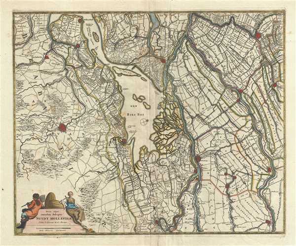
Nova atque emendata descriptio Suydt Hollandiae.
sold
- Digital Map Information
- Suitable for large format printing
- Full resolution TIFF file
- ICC color profile embedded
- Delivered instantly via download link
This is a beautiful c.1721 map of southern Holland or the Netherlands by Frederik De Wit. Oriented with north facing northwest, it extends from Gouda south to Breda and from Willemstad east as far as Culemborg. Important cities of Dordrecht, Gorinchem, Breda, ... (more details)
Map of southwest Ukraine featuring the historic region of Podolia.
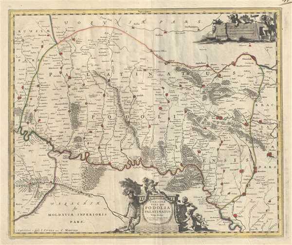
Ukrainae pars, quea Podolia Palatinatus Vulgo dicitur.
sold
- Digital Map Information
- Suitable for large format printing
- Full resolution TIFF file
- ICC color profile embedded
- Delivered instantly via download link
This is a scarce c.1721 Covens and Mortier edition of the map of the southwestern parts of Ukraine and vicinity. It covers the historic area of Eastern Europe known at the time as Podolia. It covers the regions around the Dniester River. The entire map is ... (more details)
An early triangulation chart of Florida.
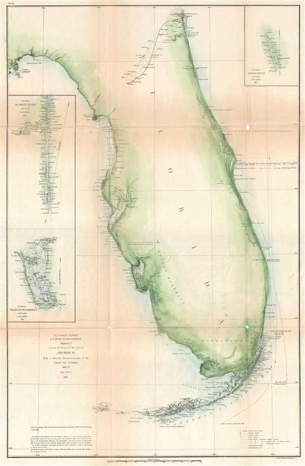
Sketch F Showing the Progress of the Survey in Section VI. With a General Reconnaissance of the Coast of Florida 1848-61.
sold
- Digital Map Information
- Suitable for large format printing
- File Size: 6.54 MB
- File Type: ZIP / TIFF
- ICC color profile embedded
- Delivered instantly via download link
A beautiful example of the U.S. Coast Survey's 1861 triangulation chart or map of the Florida Peninsula. This nautical map covers from St. Augustine and Apalachee Bay southwards as far as Key West and the Dry Tortugas. There is an interesting swath of ... (more details)
One of the first modern trianguation surveys of the Texas coastline.

Sketch I Showing the Progress of the Survey in Section No. IX form 1848 to 1860.
sold
- Digital Map Information
- Suitable for large format printing
- Full resolution TIFF file
- ICC color profile embedded
- Delivered instantly via download link
An attractive example of the 1860 U.S. Coast survey progress chart of the Texas Gulf Coast from Corpus Christi to Galveston. The map covers the Texas Coast line from Laguna Madre eastwards past Matagorda Bay to Galveston Bay. It identifies the path ... (more details)
Important early chart detailing the first modern survey of the Nantucket Shoals.
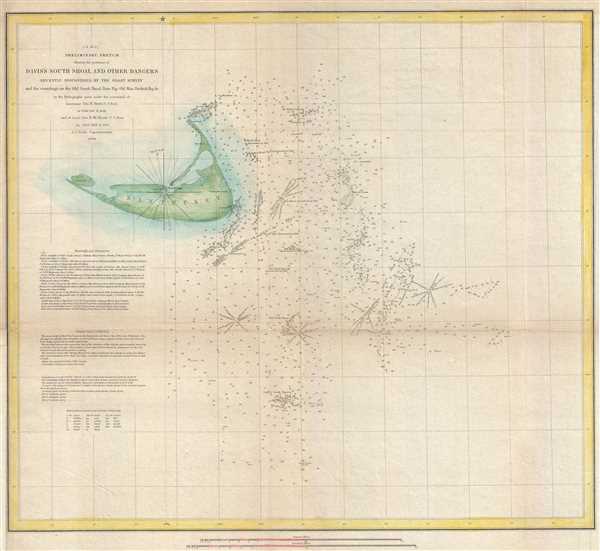
(A No. 2) Preliminary Sketch Showing the positions of Davis's South Shoal and Other Dangers recently Discovered by the Coast Survey and the sounding on the Old South Shoal, Bass Rip, Old Man, Pochuck Rip, &c.
sold
- Digital Map Information
- Suitable for large format printing
- Full resolution TIFF file
- ICC color profile embedded
- Delivered instantly via download link
This beautiful and important sea chart of map depicts the waters immediately surrounding the island of Nantucket, Massachusetts, including Davis' Shoal, Old South Shoal, and others. The chart contains a wealth of practical information for the ... (more details)
Early Coast Survey triangulation chart for Long Island.

Sketch B. No. 2 Showing the Triangulation & Geographical Positions in Section No. II From New York City to Point Judith.
sold
- Digital Map Information
- Suitable for large format printing
- DPI: 300
- File Size: 10.74 MB
- File Type: ZIP / TIFF
- ICC color profile embedded
- Delivered instantly via download link
An exceptional example of the 1851 U.S. Coast Survey's progress nautical and triangulation chart for Long Island, New York. Covers from Staten Island and New York City eastward along Long Island and the coast of Connecticut to Block Island and ... (more details)
One of the rarest and most desriable U.S. Coast Survey maps of the Chesapeake Bay.

Sketch C Showing the Progress of the Survey in Section No. III From 1842 to 1860.
sold
- Digital Map Information
- Suitable for large format printing
- Full resolution TIFF file
- ICC color profile embedded
- Delivered instantly via download link
This is an attractive example of the 1860 U.S. Coast Survey's progress chart of the Chesapeake Bay. The map covers from the mouth of the Susquehanna River southwards as far as Cape Henry and Norfolk. This chart includes both the Chesapeake ... (more details)
Early map of Brookhaven and Fire Island.

Part of Brookhaven Suffolk Co. L. I.
sold
- Digital Map Information
- Suitable for large format printing
- File Size: 10.2 MB
- File Type: ZIP / TIFF
- ICC color profile embedded
- Delivered instantly via download link
A scarce example of Fredrick W. Beers' map of the southern part of Brookhaven and Fire Island, Long Island, New York. Published in 1873, this magnificent map covers Great South Bay and East Bay and along the coast from Blue Point and ... (more details)
Early map exhibiting Islip as well as Fire Island.

Islip Suffolk County.
sold
- Digital Map Information
- Suitable for large format printing
- File Size: 8.92 MB
- File Type: ZIP / TIFF
- ICC color profile embedded
- Delivered instantly via download link
A scarce example of Fredrick W. Beers' map of the Islip, Fire Island, and Sayville, Long Island, New York. Published in 1873. Islip side covers from Babylon Cove and West Islip eastward past Bay Shore, Islip, young Point, Oakdale, ... (more details)
Early mapping of Rockaway Beach and Jamaica Bay.

Jamaica.
sold
- Digital Map Information
- Suitable for large format printing
- File Size: 11.34 MB
- File Type: ZIP / TIFF
- ICC color profile embedded
- Delivered instantly via download link
A scarce example of Fredrick W. Beers' map of greater Jamaica, Queens, New York City, including Rockaway Beach. Published in 1873. Covers roughly from Jamaica Bay northward as far as Jamaica Center and Inglewood. Includes an ... (more details)
Scarce early map of Astoria, Queens, New York City.

Astoria Part of Long Island City Town of Newtown Queens, Co. L.I.
sold
- Digital Map Information
- Suitable for large format printing
- File Size: 8.3 MB
- File Type: ZIP / TIFF
- ICC color profile embedded
- Delivered instantly via download link
A scarce example of Fredrick W. Beers' map of the southern part of Astoria, Queens, New York. Published in 1873, this magnificent map covers from Hells Gate and Halletts Cove eastward as far as Third Ave and the 'Lorrenz and ... (more details)
Beautiful map of Hunters Point, part of Long Island City in New York.

Hunters Point Part of Long Island City.
sold
- Digital Map Information
- Suitable for large format printing
- File Size: 9.38 MB
- File Type: ZIP / TIFF
- ICC color profile embedded
- Delivered instantly via download link
A scarce example of Fredrick W. Beers' map of the Hunter's Point (Long Island City), Queens, New York. Published in 1873. Covers part of what is today Long Island City from Pier Street north as far as Nott Avenue. Shows the ... (more details)
Beautiful early map of Coney Island, New York City.

Gravesend Kings Co. L.I.
sold
- Digital Map Information
- Suitable for large format printing
- File Size: 5.89 MB
- File Type: ZIP / TIFF
- ICC color profile embedded
- Delivered instantly via download link
A scarce example of Fredrick W. Beers' map parts of the region of Gravesend, Brooklyn, New York City. Published in 1873. Includes the communities of Unionville, Parkville, South Greenfield, Gravesend, Sheepshead Bay and ... (more details)
Beautiful map representing part of Long Island City, New York.

Ravenswood, Part of Long Island City, Queens, Co. L.I.
sold
- Digital Map Information
- Suitable for large format printing
- File Size: 8.54 MB
- File Type: ZIP / TIFF
- ICC color profile embedded
- Delivered instantly via download link
A scarce example of Fredrick W. Beers' map of Ravenswood, Long Island City, Queens, New York City. Published in 1873, the map details Ravenswood, part of Long Island City, Queen from the East River to what was then 6th ... (more details)
Beers' representation of Patchogue, Suffolk County, Long Island.

Patchogue Town of Brookhaven Suffolk Co.
sold
- Digital Map Information
- Suitable for large format printing
- File Size: 7.42 MB
- File Type: ZIP / TIFF
- ICC color profile embedded
- Delivered instantly via download link
A scarce example of Fredrick W. Beers' map of the town of Patchogue, Long Island, New York. Published in 1873. Detailed to the level of individual properties with landholders noted. This is probably the finest atlas ... (more details)
Beautiful map of Brooklyn highlighting Prospect Park and Greenwood Cemetery.

The City of Brooklyn.
sold
- Digital Map Information
- Suitable for large format printing
- File Size: 13.51 MB
- File Type: ZIP / TIFF
- ICC color profile embedded
- Delivered instantly via download link
A rare example of Fredrick W. Beers' Map Brooklyn, New York. Published in 1873, this map depicts Brooklyn, Greenpoint and Williamsburg. Features detail to the street level showing individual buildings, parks, and ... (more details)
Beautiful Beers' Map of western Southampton, Long Island.

Southampton.
sold
- Digital Map Information
- Suitable for large format printing
- File Size: 9.53 MB
- File Type: ZIP / TIFF
- ICC color profile embedded
- Delivered instantly via download link
A scarce example of Fredrick W. Beers’ Map of Southampton, Long Island, New York. Published in 1873, this magnificent map covers the western part of Southampton, from Eastport eastward to through West Hampton to ... (more details)
Beautiful 19th century map of New York City.

Map of central portions of the cities of New York and Brooklyn.
sold
- Digital Map Information
- Suitable for large format printing
- File Size: 11.89 MB
- File Type: ZIP / TIFF
- ICC color profile embedded
- Delivered instantly via download link
A rare example of Fredrick W. Beers' Map New York City, New York. Published in 1873, this map depicts New York City to 115th Street and parts of Brooklyn and Queens. Features detail to the street level showing ... (more details)
19th century map of Long Island City, Queens, New York.

Long Island City, Queens Co. L. I.
sold
- Digital Map Information
- Suitable for large format printing
- File Size: 10.39 MB
- File Type: ZIP / TIFF
- ICC color profile embedded
- Delivered instantly via download link
A scarce example of Fredrick W. Beers' map of the Long Island City, Queens, New York published in 1873. It covers from Hunters Point and Long Island City northward past Ravenswood and Dutch Kills to include all ... (more details)