
Unusual diagram correlating the Tropical Day, with the Zodiac, with Biblical scripture, with the 'Ages of Man.'

Curious Novelty! Differentable, & probable Ages of Man compared to a Tropical Day.
sold
- Digital Map Information
- Suitable for large format printing
- Full resolution TIFF file
- ICC color profile embedded
- Delivered instantly via download link
This is a very peculiar 1827 lithograph broadside by Richard Cox, an English East Indian, associating the 'ages of man' with scripture, and the 'Duration of a Tropical Day.' The broadside is entitled 'Curious Novelty!', which we find apt. The author states, The ... (more details)
Large plan of San Francisco.

Thomas Bros. map of the city and county of San Francisco.
sold
- Digital Map Information
- Suitable for large format printing
- Full resolution TIFF file
- ICC color profile embedded
- Delivered instantly via download link
This is a fine c.1938 pocket map or plan of the city of San Francisco by Thomas Bros. It covers San Francisco City from Lake Merced in the south to the Golden Gate Bridge in the north and from Great Highway in the west to Avisadero Point in the east. It notes ... (more details)
Charming view of South Boston.

South Boston, 1859.
sold
- Digital Map Information
- Suitable for large format printing
- Full resolution TIFF file
- ICC color profile embedded
- Delivered instantly via download link
This is a charming view of South Boston in 1859, drawn by the artist Joseph Foxcroft Cole. It depicts a beautiful view of the Dorchester Heights area of South Boston. The intersection of G Street at Thomas Park can be seen in the foreground, with the park and ... (more details)
Charming map of Yale University and New Haven Green, Connecticut

[Yale University, New Haven Green]
sold
- Digital Map Information
- Suitable for large format printing
- Full resolution TIFF file
- ICC color profile embedded
- Delivered instantly via download link
This is a charming 1930s map of Yale University and the New Haven Green in New Haven, Connecticut. It covers the privately owned park, part of the designated National Historic Landmark District bordered by College Street, Church Street, Chapel Street and Elm ... (more details)
Beautiful pictorial map of the American continent.
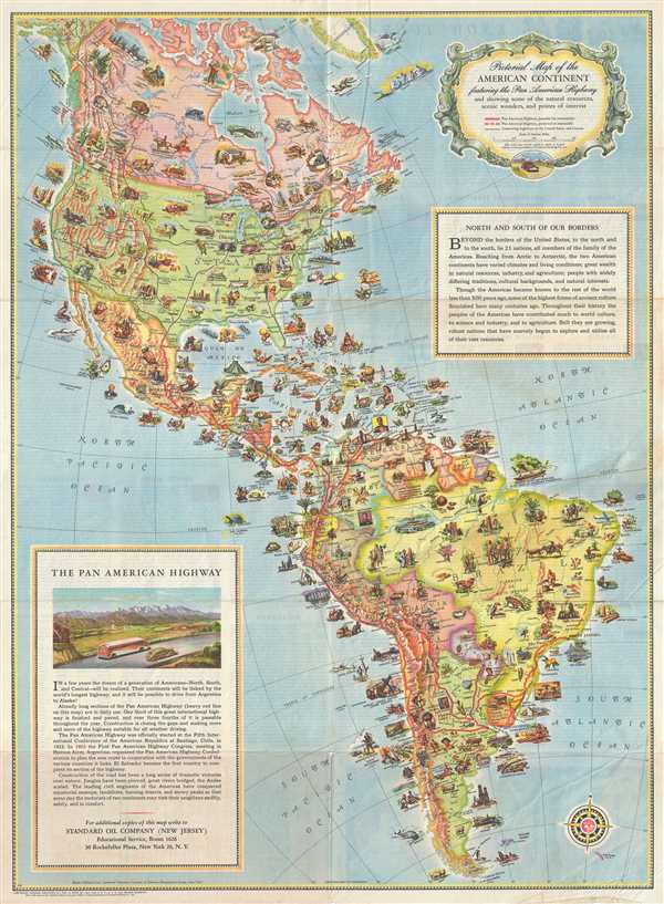
Pictorial Map of the American Continent following the Pan American Highway and showing some of the natural resources, scenic wonders, and points of interest.
sold
- Digital Map Information
- Suitable for large format printing
- Full resolution TIFF file
- ICC color profile embedded
- Delivered instantly via download link
This is a very attractive and beautifully illustrated c.1930 pictorial map of North America and South America drawn to illustrate the Pan-American Highway. The Pan-American Highway is a network of roads measuring about 29,800 miles in length. Except for an ... (more details)
An early 19th century map depicting Austria, Slovakia and the Czech Republic.

Plate X. [A general map of the Empire of Germany, Holland, the Netherlands, Switzerland, the Grisons, Italy, Sicily, Corsica, and Sardinia].
sold
- Digital Map Information
- Suitable for large format printing
- DPI: 300
- File Size: 26.75 MB
- File Type: ZIP / TIFF
- ICC color profile embedded
- Delivered instantly via download link
This is an 1800 map of eastern Austria, western Slovakia and southern Czech Republic by John Stockdale. This map covers from Voitsberg in Austria to Amschelberg in the Czech Republic and east as far as Zvolen in Slovakia. The map is highly detailed and ... (more details)
A charming hand-embroidered map of Cape Cod.

Cap Codd.
sold
- Digital Map Information
- Suitable for large format printing
- Full resolution TIFF file
- ICC color profile embedded
- Delivered instantly via download link
This is a whimsical hand-embroidered map of Cape Cod, Massachusetts. Most likely from a 1930s embroidery kit, the map covers Cape Cod in charming detail, with images of a whale, boats, a sea monster, an airplane a windmill, a house, a church, a turkey, ... (more details)
Important first edition map of the Chesapeake Bay and environs by N. Bellin.
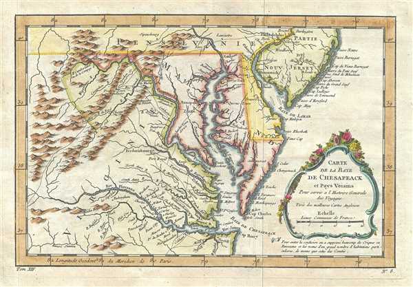
Carte de la Baye de Chesapeack et Pays Voisins.
sold
- Digital Map Information
- Suitable for large format printing
- DPI: 300
- File Size: 4 MB
- File Type: ZIP / TIFF
- ICC color profile embedded
- Delivered instantly via download link
Attributed to the French cartographer Jacques-Nicholas Bellin, this is a beautiful 1757 first state first edition map of the Chesapeake Bay including Virginia, Maryland, Delaware and parts of New Jersey and Pennsylvania. Bellin's map covers from Cape ... (more details)
Scarce early map of the Cape of Good Hope.
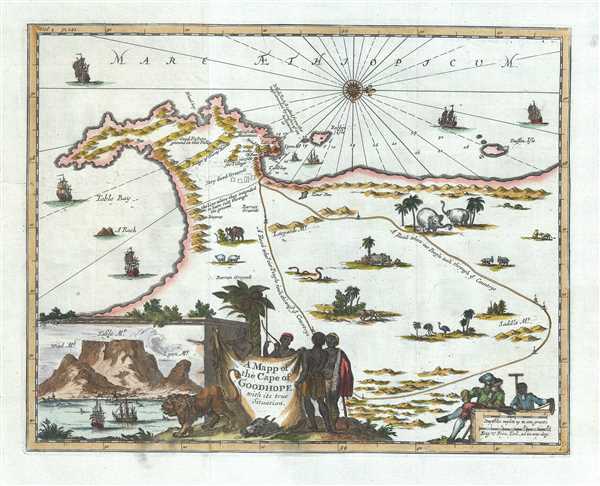
A Mapp of the Cape of Goodhope with its true Situation.
sold
- Digital Map Information
- Suitable for large format printing
- Full resolution TIFF file
- ICC color profile embedded
- Delivered instantly via download link
This is a scarce English edition 1703 map of the Cape of Good Hope in Cape Town, Africa by Dutch traveler Johannes Nieuhof. Oriented with north in the east, it covers from False Bay past the Cape of Good Hope northward past Cape Town as far as Dassen ... (more details)
An important map illustrating the Mississippi Valley during the French and Indian War.
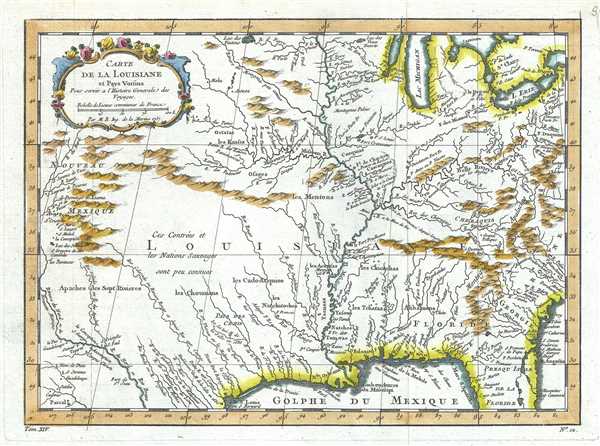
Carte de la Louisiane et Pays Voisins.
$650.00
Acquire
- Digital Map Information
- Suitable for large format printing
- DPI: 300
- File Size: 4.44 MB
- File Type: ZIP / TIFF
- ICC color profile embedded
- Delivered instantly via download link
This is an important 1757 map of the United States by the French cartographer Jacques-Nicholas Bellin. Centered on the Mississippi Valley, Bellin's map covers from the Riviere de Nord (Rio Grande) eastward to Lake Ontario and from Lake Huron to the ... (more details)
Here-to-fore unknown Persian variants of Serio-Comic maps by Fredric Rose and K. I. Kordig. Maps illustrate conflicting perspectives on Russian expansionism and the Balkan Crises.
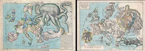
Serio-Comic Map of Europe. / Russian map of Europe.
sold
- Digital Map Information
- Suitable for large format printing
- File Size: 25.5 MB
- File Type: ZIP / TIFF
- ICC color profile embedded
- Delivered instantly via download link
An extraordinary discovery, this is a here-to-fore unknown set of Persian Serio-Comic maps issued around 1880 in Iran. These Serio-Comic maps presuppose that the reader will recognize the familiar shape of Europe and its constituent nations, which ... (more details)
An early map depicting the four fictional islands in Lake Superior. Islands later used to draw post-Revolutionary War US-Canada border.

Carte des Lacs du Canada.
sold
- Digital Map Information
- Suitable for large format printing
- DPI: 300
- File Size: 3.25 MB
- File Type: ZIP / TIFF
- ICC color profile embedded
- Delivered instantly via download link
This is an important 1757 hand colored map by French cartographer Jacques-Nicholas Bellin of the Great Lakes. It covers all five of the Great Lakes as well as the adjacent Indian lands and the English colonies of Pennsylvania, New Jersey and New ... (more details)
Fascinating speculative map of the Pacific Nortwest.

Carte Reduite des Parties Septentrionales du Globe, Situees, Entre l'Ansie et l'Amerique.
sold
- Digital Map Information
- Suitable for large format printing
- DPI: 300
- File Size: 4.45 MB
- File Type: ZIP / TIFF
- ICC color profile embedded
- Delivered instantly via download link
This fascinating 1758 hand colored map by French cartographer Jacques-Nicholas Bellin features the northernmost part of North America and Asia focusing on the Canadian Arctic and the easternmost part of Siberia, including Kamchatka. The map ... (more details)
French map issued in the fourth year of the French and Indian War.

Carte de la Caroline et Georgie.
sold
- Digital Map Information
- Suitable for large format printing
- DPI: 300
- File Size: 3.01 MB
- File Type: ZIP / TIFF
- ICC color profile embedded
- Delivered instantly via download link
This is French cartographer Jacques-Nicholas Bellin’s 1757 map of the Carolinas and Georgia. It covers modern day North Carolina, South Carolina and Georgia, and parts of Virginia and eastern Tennessee, extending from just north of the ... (more details)
Map of New England during the French and Indian War.
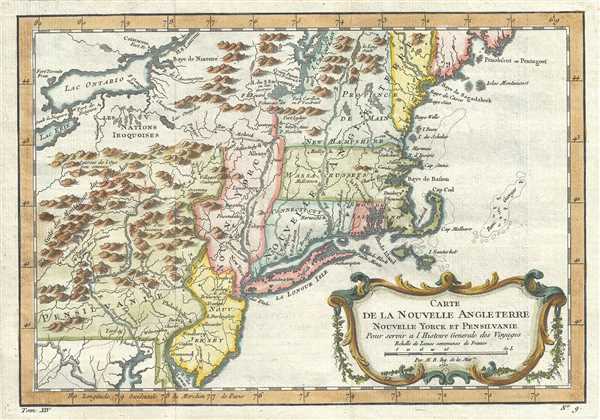
Carte de la Nouvelle Angleterre Nouvelle Yorck et Pensilvanie.
sold
- Digital Map Information
- Suitable for large format printing
- DPI: 300
- File Size: 4.23 MB
- File Type: ZIP / TIFF
- ICC color profile embedded
- Delivered instantly via download link
This beautiful 1757 hand colored map by French cartographer Jacques-Nicolas Bellin features New England, New York and Pennsylvania. The map covers the northeast showing New York, New Jersey, Connecticut, Massachusetts, New Hampshire, ... (more details)
Scarce view of Buffalo during the Pan-American Exposition.

All roads will lead to Buffalo in September.
sold
- Digital Map Information
- Suitable for large format printing
- Full resolution TIFF file
- ICC color profile embedded
- Delivered instantly via download link
A scarce 1901 view of Buffalo, New York issued by Gies and Company. Features a panoramic view of the Buffalo Metropolitan Area as seen from the south and covers from Buffalo Harbor as far north as Lake Ontario with Canada to the ... (more details)
Important first edition map of the Chesapeake Bay and environs by N. Bellin.

Carte de la Baye de Chesapeack et Pays Voisins.
sold
- Digital Map Information
- Suitable for large format printing
- DPI: 300
- File Size: 3.52 MB
- File Type: ZIP / TIFF
- ICC color profile embedded
- Delivered instantly via download link
Attributed to the French cartographer Jacques-Nicholas Bellin, this is a beautiful 1757 first state first edition map of the Chesapeake Bay including Virginia, Maryland, Delaware and parts of New Jersey and Pennsylvania. ... (more details)
One of the earliest obtainable maps of Bombay or Mumbai, India.

Plan De Bombay et de Ses Environs.
sold
- Digital Map Information
- Suitable for large format printing
- Full resolution TIFF file
- ICC color profile embedded
- Delivered instantly via download link
This beautifully hand colored c. 1750 Jacques Nicolas Bellin map of Bombay (Mumbai), India. Bellin's map illustrates Bombay as it was becoming the British East India Company's primary base of operations in India, ... (more details)
Early 18th century map or plan of Boston, Massachusetts.
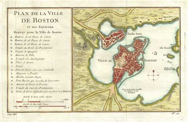
Plan de la Ville de Boston et ses Environs.
sold
- Digital Map Information
- Suitable for large format printing
- Full resolution TIFF file
- ICC color profile embedded
- Delivered instantly via download link
This hand colored map is a c. 1756 map of Boston, Massachusetts. Attributed to French cartographer Jacques-Nicholas Bellin, this map was issued for the French edition of Provost's Histoire des Voyages… . ... (more details)
The earliest obtainable map or plan of New Orleans, Louisiana.

Plan de la Nouvelle-Orleans sur les Manuscrits du Depot des Cartes de la Marine.
sold
- Digital Map Information
- Suitable for large format printing
- Full resolution TIFF file
- ICC color profile embedded
- Delivered instantly via download link
This scarce 1744 map by J. N. Bellin is the earliest obtainable map of New Orleans, Louisiana. Oriented to the northwest, Bellin's map covers the original settlement of New Orleans along the Mississippi ... (more details)