
Frederic Rose's most sophisticed 'Octopus Map'.
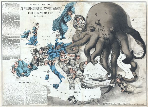
Revised Edition Serio-Comic War Map for the Year 1877.
sold
- Digital Map Information
- Suitable for large format printing
- File Size: 16.11 MB
- File Type: ZIP / TIFF
- ICC color profile embedded
- Delivered instantly via download link
Commonly known as the 'Octopus Map,' this is a remarkable 1877 caricature map of Europe by Frederic Rose. The map presupposes that the reader will recognize the familiar shape of Europe and its constituent nations, which have here been replaced by caricatures, ... (more details)
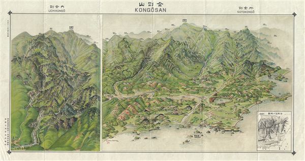
Mt. Diamond.
sold
- Digital Map Information
- Suitable for large format printing
- Full resolution TIFF file
- ICC color profile embedded
- Delivered instantly via download link
This is a rare 1923 or Taisho 12 view of Diamond Mountain or Mt. Kumgang or Kongo-San (Geumgangsan, Geumgang), in Korea or Corea. Kongo-San literally translates to 'Luminous Region.' Located in North Korea's 'Kumgangsan Tourist Region,' this mountain was ... (more details)

Korea.
sold
- Digital Map Information
- Suitable for large format printing
- Full resolution TIFF file
- ICC color profile embedded
- Delivered instantly via download link
This is a scarce 1912 or Taisho 1 Japanese map of Korea (Corea). This map of Korea, made in the first year of Emperor Taisho's reign, covers all of Peninsular Korea. It details, roads, waterways, railways, shipping lanes as well as other topographical ... (more details)
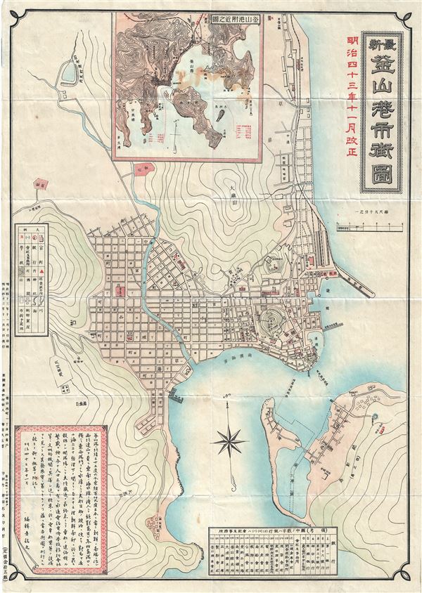
Busan.
sold
- Digital Map Information
- Suitable for large format printing
- Full resolution TIFF file
- ICC color profile embedded
- Delivered instantly via download link
This is a beautiful 1910 or Meiji 43 Japanese map of the Pusan or Busan Harbor, Korea. It covers the Busan Harbor in its entirety. Busan is the second largest metropolitan city and the largest port city in South Korea. This map details the harbor, ... (more details)

Plan of Jinsen (Chemulpo) Harbour.
sold
- Digital Map Information
- Suitable for large format printing
- Full resolution TIFF file
- ICC color profile embedded
- Delivered instantly via download link
This is a rare and attractive 1950s map or plan of the Incheon or Incheon Harbor in South Korea. It detail the harbor in the Incheon Metropolitan City located about 30 miles southwest of Seoul. The plan details the sections already constructed, in ... (more details)

West Indies.
sold
- Digital Map Information
- Suitable for large format printing
- DPI: 300
- File Size: 5.49 MB
- File Type: ZIP / TIFF
- ICC color profile embedded
- Delivered instantly via download link
This is a fine example of Thomas Cowperthwait and S. A. Mitchell's 1854 map of West Indies. It covers from Florida and the Bahamas south through the Caribbean islands of Cuba and Hispaniola (Haiti & the Dominican Republic) to the northern Part of ... (more details)

Mexico and Guatemala.
sold
- Digital Map Information
- Suitable for large format printing
- DPI: 300
- File Size: 7.63 MB
- File Type: ZIP / TIFF
- ICC color profile embedded
- Delivered instantly via download link
This is a fine example of Thomas Cowperthwait and S. A. Mitchell's 1854 map of Mexico and Guatemala. The whole is engraved and colored in Mitchell's distinctive style with green border work and vivid pastels. Political and topographical ... (more details)

A New Map of the State of California, The Territories of Oregon, Washington, Utah and New Mexico.
sold
- Digital Map Information
- Suitable for large format printing
- DPI: 300
- File Size: 8.26 MB
- File Type: ZIP / TIFF
- ICC color profile embedded
- Delivered instantly via download link
This is a scarce example of S. A. Mitchell and J. H. Young's important 1854 map of California and the western territories of Washington, Oregon, Utah, and New Mexico. Based upon Mitchell's seminal pocket map of 1846, this map covers from ... (more details)

Map of Minnesota Territory.
sold
- Digital Map Information
- Suitable for large format printing
- DPI: 300
- File Size: 7.36 MB
- File Type: ZIP / TIFF
- ICC color profile embedded
- Delivered instantly via download link
This is a fine example of S. A. Mitchell and J. H. Young's important 1854 map of Minnesota Territory. Mitchell's map covers the Minnesota Territory as it existed in 1854, extending from the Missouri River to Lake Superior and the ... (more details)

A New Map of the State of Iowa.
sold
- Digital Map Information
- Suitable for large format printing
- DPI: 300
- File Size: 8.24 MB
- File Type: ZIP / TIFF
- ICC color profile embedded
- Delivered instantly via download link
A fine example of Thomas Cowperthwait and S. A. Mitchell's 1854 map of Iowa. The whole is engraved and colored in Mitchell's distinctive style with green border work and vivid pastels. Political and topographical features are ... (more details)

A New Map of the State of Wisconsin.
sold
- Digital Map Information
- Suitable for large format printing
- DPI: 300
- File Size: 8.45 MB
- File Type: ZIP / TIFF
- ICC color profile embedded
- Delivered instantly via download link
This is a fine example of Thomas Cowperthwait and S. A. Mitchell's 1854 map of Wisconsin. The whole is engraved and colored in Mitchell's distinctive style with green border work and vivid pastels. Political and topographical ... (more details)

A New Map of Michigan with its Canals, Roads and Distances.
sold
- Digital Map Information
- Suitable for large format printing
- DPI: 300
- File Size: 7.34 MB
- File Type: ZIP / TIFF
- ICC color profile embedded
- Delivered instantly via download link
This is a fine example of Thomas Cowperthwait and S. A. Mitchell's 1854 map of Michigan. The whole is engraved and colored in Mitchell's distinctive style with green border work and vivid pastels. Political and topographical ... (more details)

A New Map of Tennessee with its Roads and Distances from place to place along the Stage and Steam Boat Routes.
sold
- Digital Map Information
- Suitable for large format printing
- DPI: 300
- File Size: 7.09 MB
- File Type: ZIP / TIFF
- ICC color profile embedded
- Delivered instantly via download link
This is a fine example of Thomas Cowperthwait and S. A. Mitchell's 1854 map of Tennessee with two inset maps: environs of Nashville and Knoxville in the upper left and right quadrants, respectively. Steam Boat routes along ... (more details)

Map of the State of Texas From the Latest Authorities.
sold
- Digital Map Information
- Suitable for large format printing
- DPI: 300
- File Size: 6.94 MB
- File Type: ZIP / TIFF
- ICC color profile embedded
- Delivered instantly via download link
This is a fine example of S. A. Mitchell and J. H. Young's important 1854 map of Texas. Mitchell's map covers the entire state of Texas from the Red River Valley to the Rio Grande, and from El Paso to the Louisiana border. ... (more details)

A New Map of Louisiana with its Canals, Roads and Distances from place to place, along the Stage and Steam Boat Routes.
sold
- Digital Map Information
- Suitable for large format printing
- DPI: 300
- File Size: 7.65 MB
- File Type: ZIP / TIFF
- ICC color profile embedded
- Delivered instantly via download link
This is an extremely attractive example of S. A. Mitchell's 1854 map of Louisiana. It depicts the entire state color coded according to individual counties. Shows canals and roads with notations regarding steamboat and ... (more details)

Map of Florida.
sold
- Digital Map Information
- Suitable for large format printing
- DPI: 300
- File Size: 6.23 MB
- File Type: ZIP / TIFF
- ICC color profile embedded
- Delivered instantly via download link
A fine example of Thomas Cowperthwait and S. A. Mitchell's 1854 map of Florida. Mitchell's map covers the entire state in considerable detail with towns, cities, counties, swamps, and reefs noted. Water routes and ... (more details)

Historical Map of the World.
sold
- Digital Map Information
- Suitable for large format printing
- Full resolution TIFF file
- ICC color profile embedded
- Delivered instantly via download link
This is a fascinating 1813 historical map of the world on hemispherical projection by R. Juigne. This early 19th century map was designed to illustrate the activities of important explorers of the 15th, 16th, 17th, ... (more details)
Highly unseal map of the world exhibiting speculative marine topography.

Mappe-Monde Physique d'Apres les Vues du Profr. Pallas Redigees par Andre Mongez Journal de Physique, Mai, 1779.
sold
- Digital Map Information
- Suitable for large format printing
- DPI: 300
- File Size: 10.29 MB
- File Type: ZIP / TIFF
- ICC color profile embedded
- Delivered instantly via download link
This is a highly unusual 1779 map of the world exhibiting a very peculiar physical topography that reveals mountain ranges both on land and under the sea. The curious undersea mountain ranges displayed here was ... (more details)
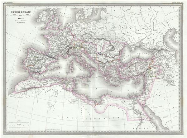
Empire Romain.
sold
- Digital Map Information
- Suitable for large format printing
- Full resolution TIFF file
- ICC color profile embedded
- Delivered instantly via download link
This is a beautiful and uncommon 1861 elephant folio map of the Roman Empire by Auguste-Henri Dufour. The map shows the extent of the Roman Empire at its height, and covers most of Europe, the Middle East, ... (more details)
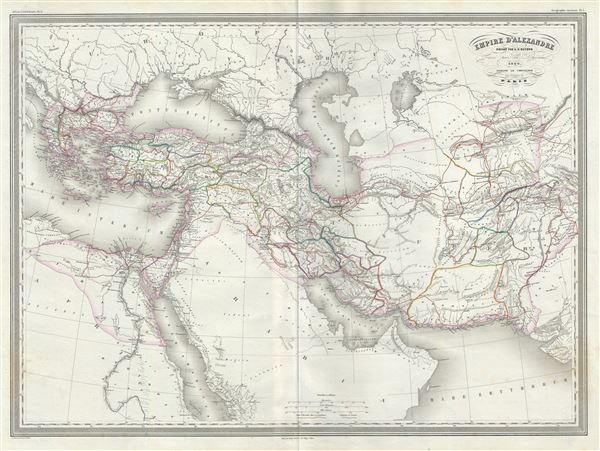
Empire d'Alexandre.
sold
- Digital Map Information
- Suitable for large format printing
- Full resolution TIFF file
- ICC color profile embedded
- Delivered instantly via download link
This is an extremely attractive and uncommon large 1860 elephant folio map of the Empire of Alexander the Great by A. H. Dufour. The map covers from Alexander's homeland in Macedonia eastwards past Asia ... (more details)