

Comparative Chart, of Continents, Oceans, Islands etc.
sold
- Digital Map Information
- Suitable for large format printing
- Full resolution TIFF file
- ICC color profile embedded
- Delivered instantly via download link
This is a fine example of the 1835 comparative map or chart of continents, oceans, islands, lakes and seas of the world by the important American mapmaker T. G. Bradford. It details the worlds continents and oceans in miles represented within concentric circles. ... (more details)

Comparative Heights of Mountains.
sold
- Digital Map Information
- Suitable for large format printing
- Full resolution TIFF file
- ICC color profile embedded
- Delivered instantly via download link
This is a beautiful 1835 map of the comparative heights of the principal mountains of the world by the important American mapmaker T. G. Bradford. It details the world's great mountains in relative proximity to one another and color coded by continent. When this ... (more details)
1835 Bradford Comparative Map of the Principle Rivers and Distribution of Vegetables and Snow Levels

Comparative Lengths of Rivers. Distribution of Vegetables, and Snow Line.
sold
- Digital Map Information
- Suitable for large format printing
- Full resolution TIFF file
- ICC color profile embedded
- Delivered instantly via download link
This is a fine 1835 comparative map by the important American mapmaker T. G. Bradford showing the comparative lengths of the principal rivers in North and South America, Europe, Asia and Africa. A large inset in the top half of the map notes the comparative ... (more details)

The Countries of The Ancient World Exhibiting the Probable Settlement of the Descendants of Noah.
sold
- Digital Map Information
- Suitable for large format printing
- Full resolution TIFF file
- ICC color profile embedded
- Delivered instantly via download link
This is a scarce 1835 map by the important American mapmaker T. G. Bradford depicting the Ancient World and the probable settlements of the descendants of Noah. It shows the Ancient World from the Atlantic Ocean to the western parts of India and from Norway ... (more details)

The World as known to the Ancients.
sold
- Digital Map Information
- Suitable for large format printing
- Full resolution TIFF file
- ICC color profile embedded
- Delivered instantly via download link
This is an uncommon and attractive 1835 map of the Ancient World, including Asia, Europe and Africa by the important American mapmaker T. G. Bradford. The map shows the Ancient World during the time of the Ancient Roman Empire from the Atlantic Ocean to ... (more details)
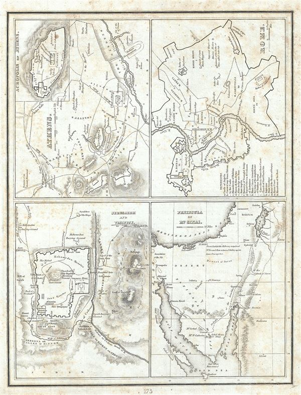
Athens. Rome. Jerusalem and Vicinity. Peninsula of Mt. Sinai.
sold
- Digital Map Information
- Suitable for large format printing
- Full resolution TIFF file
- ICC color profile embedded
- Delivered instantly via download link
This is a scarce 1835 map or plan of the ancient cities of Athens (Greece), Rome (Italy), Jerusalem (Israel) and the Peninsula of Mt. Sinai (Egypt) by the important American mapmaker T. G. Bradford. Essentially four maps on a single sheet, each map is ... (more details)

Asia Minor and the Adjacent Countries.
sold
- Digital Map Information
- Suitable for large format printing
- Full resolution TIFF file
- ICC color profile embedded
- Delivered instantly via download link
This is a scarce 1835 map of Asia Minor or what is today Turkey and its adjacent countries. It covers from Italy east to Syria and from Bulgaria south to Libya. It includes the whole or part of the modern day countries of Italy, Greece, Albania, ... (more details)
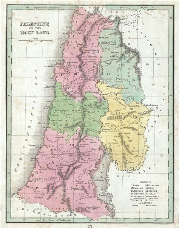
Palestine or the Holy Land.
sold
- Digital Map Information
- Suitable for large format printing
- Full resolution TIFF file
- ICC color profile embedded
- Delivered instantly via download link
This is an interesting 1835 example of the map of Israel, Palestine or the Holy Land by the important American mapmaker T. G. Bradford. It covers the region from Sidon south to the southern tip of the Dead Sea and includes the modern day nations ... (more details)

Northern Hemisphere. Southern Hemisphere.
sold
- Digital Map Information
- Suitable for large format printing
- Full resolution TIFF file
- ICC color profile embedded
- Delivered instantly via download link
This is an unusual and attractive 1835 map of the world on a polar projection by the important American mapmaker T. G. Bradford. Depicts the world as seen from the North Pole and South Pole. The Andes in South America, the Rockies in North ... (more details)

Eastern Hemisphere.
sold
- Digital Map Information
- Suitable for large format printing
- Full resolution TIFF file
- ICC color profile embedded
- Delivered instantly via download link
This is a fine 1835 map of the eastern hemisphere by the important American mapmaker T. G. Bradford. It covers the entirety of Asia, Europe and Africa as well as Australia and the East Indies and much of the Pacific. Important cities, ... (more details)

Pacific Ocean.
sold
- Digital Map Information
- Suitable for large format printing
- Full resolution TIFF file
- ICC color profile embedded
- Delivered instantly via download link
This is a beautiful 1835 map of the Pacific Ocean, Australia and Polynesia by the important American mapmaker T. G. Bradford. Centered on the Sandwich or Hawaiian Islands, it depicts the entirety of the Pacific Basin along with ... (more details)

Oceanica or Oceania.
sold
- Digital Map Information
- Suitable for large format printing
- Full resolution TIFF file
- ICC color profile embedded
- Delivered instantly via download link
A desirable 1835 map of Australia, New Zealand, Polynesia, and the east India Islands by the important American mapmaker T. G. Bradford. This map covers from Southeast Asia eastward as far as Easter Island and from Japan ... (more details)
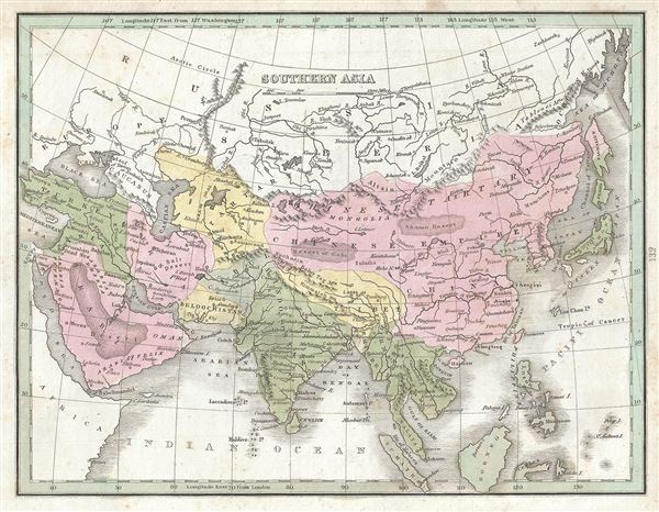
Southern Asia.
$175.00
Acquire
- Digital Map Information
- Suitable for large format printing
- Full resolution TIFF file
- ICC color profile embedded
- Delivered instantly via download link
This is a scarce 1835 map of southern Asia by the important American mapmaker T. G. Bradford. The map covers the continent from Chinese Tartary south as far as the Indian Ocean and Sumatra and from the Red Sea eastward ... (more details)

Northern Asia.
sold
- Digital Map Information
- Suitable for large format printing
- Full resolution TIFF file
- ICC color profile embedded
- Delivered instantly via download link
This is a scarce 1835 map of northern Asia by the important American mapmaker T. G. Bradford. It covers the vast expanse of northern Asia from the Caspian Sea east as far as Kamchatka and the Sakhalin Island. It ... (more details)

Farther India or Chin India, and N.W. Oceanica or Malaysia.
sold
- Digital Map Information
- Suitable for large format printing
- Full resolution TIFF file
- ICC color profile embedded
- Delivered instantly via download link
This appealing 1835 map of the East Indies and Southeast Asia was printed by the important American mapmaker T. G. Bradford. It covers from Assam and Burma (Myanmar) south as far as Timor and from the Andaman ... (more details)

China and Japan etc.
sold
- Digital Map Information
- Suitable for large format printing
- Full resolution TIFF file
- ICC color profile embedded
- Delivered instantly via download link
This is a beautiful 1835 map of China and Japan by the important American mapmaker T. G. Bradford. It covers China from Chinese Tartary to the Kingdom of Tonquin (modern day Vietnam) and from Yunnan to Corea ... (more details)
Identifies the Sea of Korea.
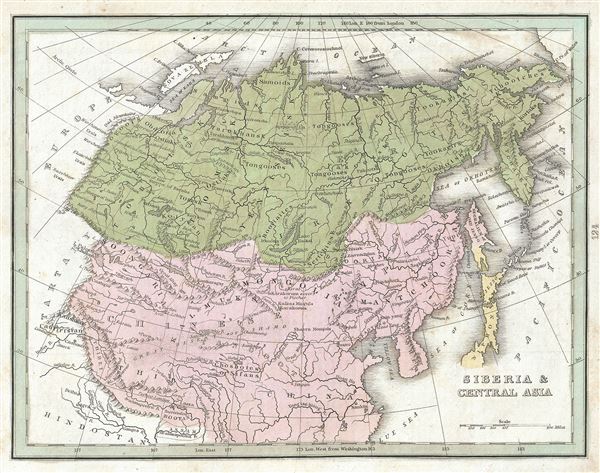
Siberia and Central Asia.
sold
- Digital Map Information
- Suitable for large format printing
- Full resolution TIFF file
- ICC color profile embedded
- Delivered instantly via download link
This is a fine example of the 1835 T. G. Bradford map of Siberia and Central Asia. Centered on the supposed site of the ancient Mongolian capital at Karakorum, this map extends from the Ural Mountains and ... (more details)
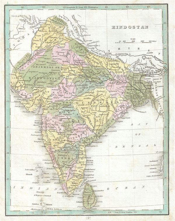
Hindostan.
sold
- Digital Map Information
- Suitable for large format printing
- Full resolution TIFF file
- ICC color profile embedded
- Delivered instantly via download link
This is a beautiful 1835 map of India by the important American mapmaker T. G. Bradford. It covers the subcontinent from Little Tibet and Cashmere south to Sri Lanka or Ceylon and from the mouth of the ... (more details)

Persia, Arabia, Tartary, Afghanistan.
sold
- Digital Map Information
- Suitable for large format printing
- Full resolution TIFF file
- ICC color profile embedded
- Delivered instantly via download link
This is a fine 1835 map of Arabia and Persia by the important American mapmaker T. G. Bradford. Detailing the declining years of the Ottoman Empire, this map is centered on Persia, and covers from Suez ... (more details)
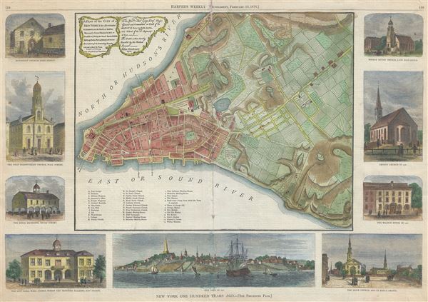
A Plan of the City of New York and Its Environs...
sold
- Digital Map Information
- Suitable for large format printing
- File Size: 12.37 MB
- File Type: ZIP / TIFF
- ICC color profile embedded
- Delivered instantly via download link
An uncommon 1876 map of New York City issued for Harper's Weekly . Presented surrounded by engraved illustrations of New York City buildings and monuments, this map, based on the map of John Montresor, ... (more details)