
1584 / 1608 Ortelius Map of China and the Philippines

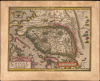
Chinae, olim Sinarum regionis, nova descriptio. auctore Ludovico Georgio.
欧洲第一张专门绘制中国地图的地图集。
- Digital Map Information
- Suitable for large format printing
- Full resolution TIFF file
- ICC color profile embedded
- Delivered instantly via download link
欧洲第一张专门绘制中国地图的地图集。
这是亚伯拉罕·奥特柳斯于1584年绘制的中国地图,也是第一幅出现在地图集中的中国、东南亚和菲律宾的详细地图,此处展示的是1608年Vrients版的原版彩色图。这是第一幅印刷的欧洲中国地图,也是第一幅将菲律宾标注为群岛的地图集。这幅地图一直是该地区的权威地图,直到1655年被卫匡国(1614-1661)的地图所取代。仔细观察
这幅地图视觉风格独特,以西方为视角,并包含丰富的装饰元素:点缀着波光粼粼的海洋中航行着船只,草原上点缀着富丽堂皇的蒙古帐篷和风车。山脉也大量出现。地图向南和向西延伸,涵盖了马来半岛和交趾支那;菲律宾出现在地图的左下角(东南角),并标注了名称。长城沿着中国北部的山地边界,以文字形式标注和描述。长城之外,地图上还标注并标注了一系列城市。一系列“第一次”
这是第一幅专门描绘中国的欧洲印刷地图(1522年的弗里斯地图未提及中国,弗里斯地图是第一幅展现中国全貌的地图)。它也是第一幅出现在现代统一地图集中的中国地图。此外,它还是第一幅标注菲律宾群岛的地图集(1578年的德·约德地图仅将该名称用于指代一个岛屿)。图中显示了棉兰老岛和宿务岛的南岸:还粗略地勾勒出一些假想的“岛屿”,但吕宋岛并未出现。苏亚雷斯在其著作《东南亚早期地图绘制》中提出,这种描绘并非源于西班牙船只从东方抵达的记载(如同麦哲伦的航迹),而是源于葡萄牙船只从西方抵达后沿海岸线前往中国的路线。这也是第一幅描绘中国长城的地图。虽然地图呈现得气势恢宏,环绕着中国整个北部边界,但随附的注释却严重低估了长城的规模:“中国国王为了抵御鞑靼人的入侵,在山脉边缘修建了一道长达四百英里的长城。”
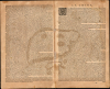
这幅地图首次描绘了风车,16世纪到访的欧洲旅行者看到这种车辆时都感到无比惊奇——有些风车可以轻松搭载300人,一天就能行驶100英里。地图背面文字是西方印刷史上最早出现的汉字。
葡萄牙文献与1556年陕西地震
地图上的葡萄牙资料对人类历史上最致命的地震的记录存在诸多误差。陕西省(三县)境内有一个圆形湖泊,湖中漂浮着一个人影,呈祈祷姿势。文字与图片相关:桑奇省的这个圆形湖泊是在 1557 年的一场洪水中形成的,当时七座城市以及城镇和村庄都被淹没,造成大量人员死亡,只有一个男孩幸免于难,他被一棵树干救了下来。故事指的是1556年陕西大地震——地震后引发了大规模洪水和山体滑坡。据估计,1556年地震震级为8级。地震引发了可怕的山体滑坡和洪水,导致多达83万居住在高崖黄土洞中的中国人丧生。中国史书对此有如下记载:
山川河流改道,道路损毁。有的地方,地面骤然隆起,形成新的山丘;有的地方,地面骤然下沉,形成新的山谷。有的地方,溪流瞬间奔涌而出;有的地方,地面崩塌,形成新的沟壑。茅屋、官邸、寺庙、城墙,纷纷轰然倒塌。地震发生后的几个月里,洪水灾害持续不断。
长城之外
长城以北虽然地名众多,但其规律性表明它们更像是列表而非地图上的地点。这些地名大多源自马可·波罗的游记,此处按顺序排列,但未标注距离。此外,还以图画形式呈现了波罗笔下帐篷居民和亭台楼阁的景象。东点
墙北的亚洲海岸线被标记为“未知” ,朝鲜半岛也未出现。日本部分出现,以葡萄牙海图典型的弧形形式呈现。(奥特柳斯在《戏剧集》的五幅不同地图上以五种不同的方式描绘了日本,这有力地说明了围绕着这个群岛的神秘之处。)伪经奇亚迈湖
神秘的清迈湖(Chiamay,又称清迈湖)位于东南亚次大陆的西端,大致在今天的印度阿萨姆邦境内。早期的制图师推测,这样一个湖泊的存在是为了汇聚东南亚四大河流:伊洛瓦底江、达拉河、湄南河和布拉马普特拉河。早在15世纪,清迈湖就出现在地图上,并一直延续到18世纪中期。清迈湖的地名由来已久,但葡萄牙人托梅·皮雷斯(Tomé Pires)在其1512-1515年出版的《东方志》(Suma Oriental)中曾提及它。斯文·赫定(Sven Hedin)的日记中也对此进行了深入探讨,他认为清迈湖与印度传说中另一个圣湖——玛旁雍错(Mansarovar)有关,后者与次大陆的几条圣河有着精神上的联系。甚至有记载表明,16世纪暹罗国王曾入侵并试图控制清迈湖。然而,奇亚迈湖最终被证实是错误的,并在 18 世纪 60 年代从地图上彻底消失了。出版历史和人口普查
这幅地图被雕刻并收录于奥特柳斯1584年出版的《世界地图集》(Theatrum Orbis Terrarum)中,此后所有版本均保留了这幅地图。此版本为1608年由约翰内斯·巴普蒂斯塔·弗里恩茨(Johannes Baptista Vrients)出版的意大利语版《世界地图集》 。弗里恩茨作为奥特柳斯的遗嘱执行人,在奥特柳斯去世后获得了该地图集的印版。范登布罗克估计,该地图集版本共印刷了三百册。OCLC收录了六册意大利语版地图集。此外,各机构收藏中也保存了这幅地图的各个版本。Cartographers
Abraham Ortelius (April 14, 1527 - June 28, 1598) also known as Ortels, was a cartographer, geographer, and cosmographer of Brabant, active in Antwerp. He was the creator of the first modern atlas, Theatrum Orbis Terrarum and is a seminal figure in the history of cartography. Along with Gerard Mercator and Gemma Frisius, he was a founder of the Netherlandish school of cartography. His connections with Spain - culminating in his 1575 appointment as Royal Cartographer to King Phillip II of Spain - gave him unmatched access to Spanish geographical knowledge during a crucial period of the Age of Discovery. Ortelius was born in 1527 in Antwerp. In 1547 he entered the Antwerp Guild of Saint Luke as an illuminator of maps. He began trading in books, prints, and maps, traveling regularly to the Frankfurt book and print fair, where in 1554 he met Mercator. He accompanied Mercator on journeys throughout France in 1560 and it was at this time, under Mercator's influence, that he appears to have chosen his career as a scientific geographer. His first published geographic work appeared in 1564, an eight-sheet cordiform world map. A handful of other maps preceded the 1570 publication of the first edition of the Theatrum Orbis Terrarum, which would prove to be his life work. Appearing with but 53 maps in its first edition, Ortelius' work expanded with new maps added regularly. By 1592, it had 134 maps. Many of Ortelius' maps remained the standard for nearly a century. He traveled extensively, but his genius was as a compiler, locating the best informed maps on which to base his own. His contacts throughout Europe and extending even (via the Portuguese) to the Far East were formidable. Moreover, many of his maps were based on his own scholarship, particularly his historical works. His theories of geography were particularly ahead of his time with respect to the notion of continental drift, the possibility of which he mused on as early as 1596, and which would be proven correct centuries later. In a sense his greatest achievement was his successful navigation of the religious and political violence endemic to his city throughout his adult life: The Dutch Revolt, or Eighty Years' War (1568 - 1648), fully embroiled Antwerp. Although outwardly and officially recognized as Catholic (Arias Montanus vouched for Ortelius' Catholic orthodoxy prior to his appointment as Royal Geographer), Ortelius was able to separate himself from the religious furor which characterized the war in the low countries. Ortelius showed a glimpse of himself in a letter to a friend, regarding humanist Justus Lipsius: 'I do not know whether he is an adherent of the Pope or a Calvinist, but if he has ears to hear, he will neither be one nor the other, for sins are committed on both sides'. Ortelius' own explorations of Biblical history in his maps, and the Christogram contained in his own motto, suggest him to be a religious man, but his abjuration of political religious authorities mark him as an individualist. His tombstone at St Michael's Præmonstratensian Abbey in Antwerp bears the inscription, Quietis cultor sine lite, uxore, prole. ('served quietly, without accusation, wife, and offspring.') Further Details...
Luiz Jorge de Barbuda (1564? - 1613? ) was a Portuguese cartographer. He is known primarily as the individual credited by Abraham Ortelius as the source for During his 1584 map of China, the first map specifically of China to appear in an atlas. Little is known of his early history and there is little agreement by scholars on his dates. It is understood that he was, in 1582, commissioned by Philip II of Spain to produce navigation charts and world maps. His role as an official cartographer for Spain makes the appearance of his map in Ortelius' atlas all the more remarkable: The Spanish were reluctant to share any of their cartographic information and printed virtually none of it in the 16th and 17th centuries. Nevertheless, his Chinaeappeared in Ortelius' Theatrum Orbis Terrarum accompanied by a brief description of China and its language, derived from Bernardino de Escalante's 1577 Discurso de la navegacion que los Portugueses hacen a los Reinos y Provincias de Oriente, Spain's first book about China. Both the map and the description published in Ortelius' work would remain the most authoritative European description of China until Martini's 1655 work became available. Further Details...
Johannes Baptista Vrients (1552 - 1612) was a Flemish engraver, publisher, and mapseller. Little is known of his early years, but it is to be assumed he came up as an apprentice among the mapmakers of Antwerp, where the guild named him a master in 1575. In the 1590s, he executed world maps for Plancius and Linschoten. (In 1600, after Ortelius died, he became the estate's executor and acquired the plates for the Theatrum.) He would go on to publish further editions of the Ortelius atlas between 1606 and 1612. Vrients also acquired the plates for Gerard De Jode's (1516/17 - 1591) Speculum in and around 1600, but he did not republish that work - though he would preserve the De Jode plates depicting the Electors of the Holy Roman Empire, reprinting it in his editions of the Ortelius atlas after 1603. Most likely, his purchase of the De Jode plates was a play to keep them off the market. Vrients' editions of the Theatrum were not published in Antwerp (that city having fallen during the Dutch war with Spain) but in Amsterdam. Further Details...
Source
Ortelius, A., Theatro del Mondo, (Antwerp: Vrients) 1602.
Abraham Ortelius' magnum opus, Theatrum Orbis Terrarum, was the world's first regularly produced atlas, which 'set the standards for later atlases ... It was the first undertaking of its kind to reduce the best available maps to an uniform format.' (Koeman) A modestly-sized work of fifty-three maps in its first edition of May 1570, it was an immediate success: there were three further editions that year, and the work remained in print for a total of 32 editions, the last of which was 1641, well after its author's 1598 death. Ortelius added to his atlas constantly, and by 1595 the Theatrum contained 147 maps. Ortelius is renowned generally as an editor, and indeed much of the Theatrum is compiled from a variety of sources: in such cases, Ortelius was scrupulous in naming his sources. But Ortelius was also a mapmaker in his own right: many of his maps are a distillation of various sources into his own work, and there were many maps - particularly in his atlas of Biblical and ancient history Parergon - which were entirely Ortelius' work. In his role as an editor, Ortelius followed in the footsteps of Munster, whose Cosmographia was, until Ortelius, the best window on the world for the curious European reader. In terms of the artistry of his maps, Ortelius oversaw the first great flourishing of copperplate engraving in the service of cartography to occur in Northern Europe. Ortelius' work provided the model for the atlases of Mercator, Hondius, Blaeu and all their progeny in the 17th century - many of whom were to produce faithful editions of Ortelius' maps in their own productions.
Condition
Very good. Few marginal mends not impacting printed image. Light toning; else excellent with fine original color.
References
OCLC 710854465. Rumsey 10001.305. Van den Broecke 164.3. Van der Krogt, P. C. J., Koeman's Atlantes Neerlandici, (3 Vols), 31:651. Tibbets G. R., Arabia in Early Maps, map 27, p. 46.