
1952 USGS / Aramco Arabic Wall Map of the Arabian Peninsula

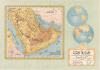
جزيرة العرب و المناطق المتاخمة لها خريطة تمهيدية / [The Arabian Peninsula and Adjacent Regions An Introductory Map].
A Defining Era for Aramco.
- Digital Map Information
- Suitable for large format printing
- File Size: 147.51 MB
- File Type: ZIP / TIFF
- ICC color profile embedded
- Delivered instantly via download link
A Defining Era for Aramco.
This is a stunning, large-format 1952 Arabic-language wall map of the Arabian Peninsula, issued by the oil giant, the Arabian American Oil Company (Aramco). It was issued at a critical time in the company's history, following its rearrangement to a 50/50 profit-sharing agreement with the Saudi state and the discovery in 1951 of the Safaniya Oil Field, the world's largest offshore field.A Closer Look
The sheet consists of a map, occupying the left two-thirds of the sheet, a projection of the two hemispheres at top-right (highlighting the area presented on the main map), and a title panel at bottom-right. The map covers the Arabian Peninsula and environs, using shading to represent terrain. Cities, national border, roads, railways, and topographic features are indicated and labeled throughout. The newly discovered Safaniya Oil Field is not labeled here (perhaps because the map was initially prepared in 1950, before its discovery) but the Cape of Safaniya (راس السفانية) is, near the border with Kuwait. The map is notable for referring to the Persian Gulf (الخليج الفارسي) as such, instead of the term 'Arabian Gulf' (الخليج العربي), which became standard in Arab countries with the rise of pan-Arabism and, more recently, geopolitical enmity with Iran.Territorial Disputes
A note at bottom-right explains that the information on the map is based on surveys undertaken in 1942 and is not meant to be considered definitive or up-to-date. Part of the significance of this note is that Saudi Arabia and other Gulf States had ongoing border disputes. One of these, called the Buraimi Dispute after the Buraimi Oasis (البريمي; due south of the Musandam Peninsula), threatened to cause a war between Saudi Arabia and the Trucial States, namely Abu Dhabi, and Oman, backed by Great Britain. The territory had been contested for some years, with Saudi claiming trial affinity with the local Bedouins and Abu Dhabi/Oman pointing to earlier British territorial divisions, but when Aramco's oil exploration in the region (illegal exploration according to the Emiratis and Omanis) indicated there might be significant reserves there, the dispute became much more heated. War threatened throughout the early 1950s, with small armed incursions by the different sides and failed attempts to arbitrate the dispute. Eventually, in October 1955, Britain sent in a larger force to drive out the Saudis, pushed the Saudi-aligned Bedoins to accept a ceasefire, and divided the oasis between Oman and Abu Dhabi. The issue remained a sore spot in Saudi-Emirati relations until the mid-1970s and delayed the Saudi recognition of the independent United Arab Emirates for several years.Historical Context
In the early 1950s, Aramco entered a period of major transformation shaped by the post-World War II environment, including the Cold War, decolonization, and pan-Arabism. In 1950, after observing similar developments in Venezuela and responding to growing demands from King Abdulaziz's government, Aramco and Saudi Arabia concluded a landmark 50/50 profit-sharing agreement, which guaranteed that the Kingdom would receive half of Aramco's net profits, dramatically increasing state revenues. Although ownership of the company remained American (until 1988), the agreement set a precedent that reshaped the global oil industry and strengthened the partnership between Saudi leaders and the company operating within their territory. At this time, the company's headquarters was also relocated from New York to Dhahran.Meanwhile, Aramco's exploration efforts continued to uncover vast new petroleum resources on and around the Arabian Peninsula, most notably the discovery of the Safaniya Oil Field in 1951. Located in the shallow waters of the Persian Gulf, Safaniya would later prove to be the world's largest offshore oil field, and even in its early years it signaled the enormous offshore potential of Saudi Arabia's hydrocarbon reserves. Safaniya's discovery not only bolstered production capacity in the 1950s but also reinforced Saudi Arabia's long-term position as a global energy powerhouse, complementing the political and economic significance of the new profit-sharing framework.
Publication History and Census
This map was issued by Aramco in 1952 (1371 A.H.), based on surveys undertaken by the U.S. Geological Survey. It is quite scarce, only being noted in institutional collections at Princeton University, the University of Manchester, the Qatar National Library, the American University of Beirut, the Beirut Arab University, and NYU Abu Dhabi (which dates it to 1950, perhaps a cataloging error as the map noted being printed in 1950 but published in 1952). Scarce to the market.Cartographers
Arabian American Oil Company (active 1932 - Present) Dhahran-based Aramco (now Saudi Aramco (Arabic: أرامكو السعودية ʾArāmkū s-Saʿūdiyyah) is a Saudi Arabian public petroleum and natural gas company. Initially named California-Arabian Standard Oil Co., it was formed by a coalition of American companies seeking new sources of oil, having been excluded from Mesopotamian oil fields by United Kingdom and France since 1920. In the late forties the company's headquarters were moved from New York to Dhahran, but the company maintained offices in the United States (including the company's P.R. department.) Further Details...
The United States Geological Survey (1878 - Present), aka the U.S.G.S., is a scientific agency of the United States government, which was founded in 1879. USGS scientists study the landscape of the United States, its natural resources, and the natural hazards that threaten it. The organization has four major science disciplines: biology, geography, geology, and hydrology. It is a bureau of the United States Department of the Interior and is the department's only scientific agency. Further Details...
Condition
Very good. Laid down on archival paper.
References
OCLC 642632543, 1406842403, 784574952.