
1952 USGS / Aramco Arabic Wall Map of the Arabian Peninsula

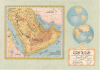
جزيرة العرب و المناطق المتاخمة لها خريطة تمهيدية / [The Arabian Peninsula and Adjacent Regions An Introductory Map].
حقبة حاسمة لشركة أرامكو.
- Digital Map Information
- Suitable for large format printing
- File Size: 147.51 MB
- File Type: ZIP / TIFF
- ICC color profile embedded
- Delivered instantly via download link
حقبة حاسمة لشركة أرامكو.
هذه خريطة جدارية رائعة كبيرة الحجم لشبه الجزيرة العربية، صدرت عام ١٩٥٢ عن شركة النفط العملاقة، شركة الزيت العربية الأمريكية (أرامكو). وقد صدرت في وقت حرج من تاريخ الشركة، بعد إعادة هيكلتها إلى اتفاقية تقاسم الأرباح بنسبة ٥٠/٥٠ مع الدولة السعودية، واكتشاف حقل السفانية النفطي عام ١٩٥١، وهو أكبر حقل نفطي بحري في العالم.نظرة فاحصة
تتألف هذه الورقة من خريطة تشغل الثلثين الأيسرين منها، وإسقاط لنصفي الكرة الأرضية في أعلى اليمين (يُبرز المنطقة المعروضة على الخريطة الرئيسية)، ولوحة عنوان في أسفل اليمين. تغطي الخريطة شبه الجزيرة العربية والمناطق المحيطة بها، مستخدمةً التظليل لتمثيل التضاريس. وتُشير الخريطة إلى المدن والحدود الوطنية والطرق والسكك الحديدية والمعالم الطبوغرافية مع وضع تسميات عليها. لم يُذكر حقل السفانية النفطي المكتشف حديثًا هنا (ربما لأن الخريطة أُعدت في الأصل عام ١٩٥٠، قبل اكتشافه)، ولكن رأس السفانية مذكور بالقرب من الحدود مع الكويت. وتتميز الخريطة باستخدامها مصطلح "الخليج الفارسي" بدلًا من "الخليج العربي"، الذي أصبح شائعًا في الدول العربية مع صعود القومية العربية، ومؤخرًا، مع العداء الجيوسياسي مع إيران.النزاعات الإقليمية
توضح ملاحظة في أسفل اليمين أن المعلومات الواردة في الخريطة تستند إلى مسوحات أُجريت عام ١٩٤٢، ولا يُقصد بها أن تُعتبر نهائية أو مُحدَّثة. تكمن أهمية هذه الملاحظة في أن المملكة العربية السعودية ودول الخليج الأخرى كانت تشهد نزاعات حدودية مستمرة. أحد هذه النزاعات، المعروف باسم نزاع البريمي نسبةً إلى واحة البريمي (جنوب شبه جزيرة مسندم)، هدد بإشعال حرب بين المملكة العربية السعودية والإمارات المتصالحة، وتحديدًا أبوظبي وعُمان، بدعم من بريطانيا العظمى. كانت المنطقة محل نزاع لسنوات، حيث ادعت السعودية وجود صلة قرابة مع البدو المحليين، بينما أشارت أبوظبي/عُمان إلى تقسيمات حدودية بريطانية سابقة. ولكن عندما أشارت عمليات التنقيب عن النفط التي قامت بها شركة أرامكو في المنطقة (والتي وصفها الإماراتيون والعمانيون بأنها تنقيب غير قانوني) إلى احتمال وجود احتياطيات كبيرة، اشتد النزاع. وهددت الحرب المنطقة طوال أوائل الخمسينيات، مع توغلات مسلحة صغيرة من مختلف الأطراف ومحاولات فاشلة للتحكيم في النزاع. في نهاية المطاف، في أكتوبر/تشرين الأول 1955، أرسلت بريطانيا قوة أكبر لطرد السعوديين، وضغطت على البدو الموالين للسعودية لقبول وقف إطلاق النار، وقسمت الواحة بين عُمان وأبوظبي. وظلت هذه القضية نقطة خلاف في العلاقات السعودية الإماراتية حتى منتصف سبعينيات القرن العشرين، وأخرت اعتراف السعودية بدولة الإمارات العربية المتحدة المستقلة لعدة سنوات.السياق التاريخي
في أوائل خمسينيات القرن العشرين، دخلت أرامكو مرحلة تحول جذري تأثرت بظروف ما بعد الحرب العالمية الثانية، بما في ذلك الحرب الباردة، وإنهاء الاستعمار، والقومية العربية. في عام ١٩٥٠، وبعد رصد تطورات مماثلة في فنزويلا، واستجابةً للمطالب المتزايدة من حكومة الملك عبد العزيز، أبرمت أرامكو والمملكة العربية السعودية اتفاقية تاريخية لتقاسم الأرباح بنسبة ٥٠/٥٠، مما ضمن حصول المملكة على نصف صافي أرباح أرامكو، الأمر الذي زاد إيرادات الدولة بشكل كبير. ورغم بقاء ملكية الشركة أمريكية (حتى عام ١٩٨٨)، إلا أن الاتفاقية أرست سابقة أعادت تشكيل صناعة النفط العالمية وعززت الشراكة بين القادة السعوديين والشركة العاملة على أراضيهم. في ذلك الوقت، نُقل مقر الشركة الرئيسي من نيويورك إلى الظهران.في غضون ذلك، واصلت أرامكو جهودها الاستكشافية لاكتشاف موارد نفطية جديدة هائلة في شبه الجزيرة العربية وحولها، وأبرزها اكتشاف حقل السفانية النفطي عام ١٩٥١. يقع حقل السفانية في المياه الضحلة للخليج العربي، وقد أثبت لاحقًا أنه أكبر حقل نفط بحري في العالم، وحتى في سنواته الأولى، أشار إلى الإمكانات الهائلة لاحتياطيات المملكة العربية السعودية من الهيدروكربونات في المياه العميقة. لم يُعزز اكتشاف السفانية القدرة الإنتاجية في خمسينيات القرن الماضي فحسب، بل عزز أيضًا مكانة المملكة العربية السعودية على المدى الطويل كقوة عالمية في مجال الطاقة، مكملاً بذلك الأهمية السياسية والاقتصادية لإطار تقاسم الأرباح الجديد.
تاريخ النشر والإحصاء
أصدرت شركة أرامكو هذه الخريطة عام ١٩٥٢ (١٣٧١ هـ)، استنادًا إلى مسوحات أجرتها هيئة المسح الجيولوجي الأمريكية. وهي نادرة جدًا، إذ لا توجد إلا في مجموعات مؤسسية في جامعة برينستون، وجامعة مانشستر، ومكتبة قطر الوطنية، والجامعة الأمريكية في بيروت، وجامعة بيروت العربية، وجامعة نيويورك أبوظبي (التي تؤرخها إلى عام ١٩٥٠، وربما يكون ذلك خطأً في الفهرسة، حيث ذُكر أن الخريطة طُبعت عام ١٩٥٠ ولكنها نُشرت عام ١٩٥٢). وهي نادرة في السوق.Cartographers
Arabian American Oil Company (Aramco; predecessor established 1933; name used 1944 - 1988) was an American-owned petroleum exploration and production company operating in Saudi Arabia, headquartered in Dhahran from 1952, whose survey departments made substantial contributions to the geographic and geological mapping of the Arabian Peninsula during the mid-20th century. Its origins lay in the petroleum concession granted to Standard Oil Company of California in 1933 and administered through its subsidiary, California Arabian Standard Oil Company. Commercial oil production began at Dammam No. 7 in 1938, and the company adopted the Arabian American Oil Company name in 1944. Standard Oil Company of New Jersey and Socony-Vacuum acquired interests in 1948, broadening its American ownership; its headquarters moved from New York to Dhahran in 1952. Cartographic work developed alongside geological exploration, combining ground reconnaissance, astronomical observations, triangulation, leveling, and aerial photography. Beginning in 1949, aerial mapping supplied the photographic foundation for increasingly systematic geographic coverage, while company surveyors established horizontal and vertical control. Aramco's Arabian Affairs Division also evaluated place names, consulting Saudi informants and working toward consistent Arabic and English nomenclature. In the mid-1950s, Aramco joined the United States Geological Survey in a cooperative mapping program sponsored by the Saudi government and the United States Department of State. The program provided for 21 quadrangles at 1:500,000, with separate geographic and geological versions and bilingual nomenclature. Aramco assumed responsibility for compiling the sedimentary regions, while the Geological Survey principally covered the western Arabian Shield. Geographic sheets appeared from 1956 to 1962 and geological sheets from 1956 to early 1964; the collaboration also produced a preliminary peninsula-wide geographic map in 1958, a revised edition in 1963, and the Geologic Map of the Arabian Peninsula at 1:2,000,000 in 1963. These publications made extensive company exploration data available for scientific and economic use beyond petroleum operations. Saudi government participation in Aramco began in 1973 and reached complete ownership in 1980. In 1988, the newly established Saudi Arabian Oil Company, known as Saudi Aramco, succeeded to Aramco's responsibilities. Further Details...
The United States Geological Survey (March 3, 1879 - present), commonly abbreviated USGS, is an American federal scientific bureau and civilian mapping agency within the Department of the Interior, established in Washington, D.C., and subsequently headquartered in Reston, Virginia. Congress created the Survey to classify public lands and investigate the geological structure, mineral resources, and products of the national domain, replacing separate western investigations with a permanent scientific organization. Its first director, Clarence King (1842 - 1901), organized geological investigations and recruited experienced scientists and topographers from earlier federal surveys. Under his successor, John Wesley Powell (1834 - 1902), director from 1881 to 1894, topographic mapping expanded from support for individual geological investigations into a nationwide undertaking. Congressional authorization in 1882 to continue preparation of a geological map of the United States extended the Survey's work into the eastern states, while systematic topographic mapping received authorization in 1884. Henry Gannett (1846 - 1914), the Survey's chief geographer, helped establish enduring methods and standards for this work. Its topographic quadrangles represented terrain through contour lines alongside drainage, settlements, roads, and other features, furnishing a common geographic foundation for scientific investigation and practical land use. During the 20th century, the Survey's mapping evolved from field surveying and compilation toward aerial photography, photogrammetry, and digital geographic information systems. A formal program begun in 1947 to map the conterminous United States at 1:24,000 scale culminated in nationwide coverage in 1992, comprising more than 55,000 maps. The Survey also produced geological and thematic maps and assembled national geographic information. In 2009 it introduced US Topo, a digitally generated successor to its traditional topographic quadrangles. Its continuing cartographic work includes The National Map, digital topographic products, and public access to historical quadrangles, alongside broader investigations of water, ecosystems, mineral and energy resources, and natural hazards. Further Details...
Condition
Very good. Laid down on archival paper.
References
OCLC 642632543, 1406842403, 784574952.