
1972 al-Sabbagh Arabic World Atlas, w/ Focus on United Arab Emirates

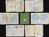
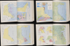
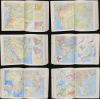
أطلس الامارات العربية المتحدة والعالم / [Atlas of the United Arab Emirates and the World].
The Emirates' Earliest School Atlas.
The Emirates' Earliest School Atlas.
This is a c. 1972 Arabic-language school atlas of the world with a focus on the United Arab Emirates, published by Said Sabbagh in Beirut. It is likely the earliest published atlas to specifically highlight the Emirates following their independence from Britain in late 1971.A Closer Look
True to its title, the atlas includes maps of the entire world, parts of the world outside of the Middle East, maps of countries in the Arab World (including Israel-Palestine), and several maps focusing specifically on the United Arab Emirates. Though a school atlas, it is remarkably comprehensive; for instance, the second and third pages provide detailed descriptions about various common methods of projection for world maps, along with information on longitude and latitude, the poles, and time zones. Pages six and seven provide not only a dual-hemisphere physical map of the world but also illustrations of eclipses, phases of the moon, and the tropics. This fastidiousness is even more evident in the maps of the UAE, which cover all aspects of its topography, geology, terrain, climate, demographics, and economy (including maps of oil resources and oil company concessions). Other countries in the region also receive several dedicated maps, including Israel-Palestine and Kuwait.This atlas was presumably used in schools in the UAE in the years just after the country's independence. The maps of the UAE itself were very likely based on the groundbreaking cartographic work of Mohammed Morsi Abudullah (see our earlier listings AbuDhabi-abdullah-1971 and UnitedArabEmirates-morsy-1973 for background).
The Formation of the UAE
In the mid-20th century, the future constituent kingdoms of the United Arab Emirates were the Trucial States along the Persian Gulf coast under British protection, a status that dated back to the early 19th century when Britain sought to secure maritime routes to India. (Technically, the states were part of the East India Company's Persian Gulf Residency and then the Raj, and the Indian rupee was the de facto currency among the territories.) The generally poor pearling and trading societies of the Trucial States began to transform thanks to the discovery of oil off Abu Dhabi in 1958, giving them a growing economic and political significance. In 1968, when Britain announced its intention to withdraw from 'east of Suez' by 1971, Abu Dhabi's ruler, Sheikh Zayed, took the lead in organizing a new political framework to ensure stability after the end of British oversight. Zayed entered negotiations with the rulers of the other Trucial States, as well as Bahrain and Qatar, to form a federation that would balance local autonomy with collective security and development.These efforts culminated in the creation of the UAE on December 2, 1971, one day after formal independence from Britain, when Abu Dhabi and five other emirates (Dubai, Sharjah, Ajman, Umm al-Quwain, and Fujairah) formally united, with Ras al-Khaimah joining in early 1972. Abu Dhabi, the largest and wealthiest emirate, became the capital of the new federation, and Sheikh Zayed was chosen as its first president. The constitution of the UAE established a federal system that preserved the sovereignty of each emirate while centralizing key areas such as defense, foreign policy, and economic coordination. Abu Dhabi's oil wealth and Zayed's leadership provided the financial and political foundation for the federation's early stability and rapid modernization.
Publication History and Census
This atlas was prepared by Said Sabbagh in Beirut, in collaboration with George Philip and Son and the Geocartography Studio de Agostini in Milan, and was distributed by the Publications Distribution and Publishing Company (شركة المطبوعات للتوزيع والنشر) in Abu Dhabi. It is undated but must postdate the formation of the United Arab Emirates in December 1971. The atlas is quite rare; as it is undated, cataloging is somewhat confused, but examples are held by the National Library of Israel (dated c. 1974) and several institutions in the UAE listed in the Arabic Union Catalog, including Emirates University (dated c. 1980).Cartographers
Said Kamel Sabbagh (1899 - 1967) (سعيد كامل الصباغ) was a Palestinian-Lebanese geographer known for publishing textbooks on the geography of the Arab world. He was born in Haifa and as a child moved to Sidon and then to Beirut. Initially schooled in commerce, he instead turned to teaching and education administration, work which brought him back to Haifa and then to Safed. During this time, he began to publish geographical works, for both a scholarly and general audience. Over his career, he authored or co-authored 14 books and late in life oversaw the production of a large wall map of Palestine on the eve of the First Arab-Israeli War which became a standard reference work for the Palestine Liberation Organization. Further Details...
George Philip (1800 - 1882) was a map publisher and cartographer active in the mid to late-19th century. Philip was born into a Calvinst family in Huntly, Aberdeenshire, Scotland. Around 1819 he apprenticed himself to William Grapel, a Liverpool printer and bookseller. Fifteen years later, in 1834, Philip founded his own Liverpool book and map firm. Philip's earliest cartographic ventures were mostly educational material issued in tandem with John Bartholomew Sr., August Petermann, and William Hughes. In 1848, Philip admitted his son, George Philip Jr. (1823 - 1902) into the firm, renaming it George Philip and Son Ltd. George Philip Jr. ran the firm until his death in 1902, by which time it had developed into a major publishing concern. His successors established the London Geographical Institute, a factory where they embraced modern printing techniques to produce thousands of economical and high quality maps. In April 1988, George Philip & Son was acquired by Octopus Publishing, a branch of Reed International. Nonetheless, today the firm trades and publishes to this day as George Philip and Son. Further Details...
Giovanni De Agostini (August 23, 1863 - November 21, 1941) was an Italian cartographer and publisher. In 1901, he founded the Istituto Geografico Italiano del dott. G. De Agostini and C. in Rome. In addition to school atlases, the group published the Calendario Atlante de Agostini, a compact yearbook, calendar, and atlas, which was highly successful. In 1908, the company moved to Novara in Piemonte, in large part to be closer to Germany, from where they sourced their equipment. In 1919, the company was acquired by Marco Boroli and Cesare Rossi and began to expand more rapidly, including the installation of Italy's first rotogravure printing press and the publication of the esteemed Grande Atlante Geografico, though it retained its name and identity. After De Agostini's death, the Istituto geografico and publishing house he had founded continued to use his name. His younger brother, Alberto Maria de Agostini (1883 - 1960) was a Salesian priest and polymath who lived most of his life in Tierra del Fuego and Patagonia, contributing greatly to the geographic and ethnographic knowledge of the region. Giovanni's son, Federico De Agostini (1905 - 1960), began working at the firm in 1927 and was known for his own discoveries in South America as well as several important maps, textbooks, encyclopedias, and murals, including some in Arabic. Another of Agostini's sons, Giovanni De Agostini, Jr., became especially adept at speaking and reading Arabic and was an expert on the history of Islam. In the years after the Second World War, the company retained the name Agostini but was fully taken over by the Boroli family. It diversified into publishing school textbooks, books on art, children's books, encyclopedias, and more. In subsequent decades, it became one of the best known Italian publishing houses and expanded throughout Europe to become a multifaceted international holding company with publishing, cartographic, arts, media, gaming, and asset management subsidiaries. Further Details...
Condition
Good. Some scuffing to covers. Spine wear.
References
National Library of Israel, System No. 990039933940205171. Emirates University, G1021 .A844 1980.